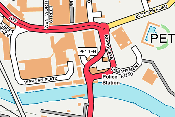
PE1 1EH is located in the Central electoral ward, within the unitary authority of Peterborough and the English Parliamentary constituency of Peterborough. The Sub Integrated Care Board (ICB) Location is NHS Cambridgeshire and Peterborough ICB - 06H and the police force is Cambridgeshire. This postcode has been in use since January 1980.


GetTheData
Source: OS OpenMap – Local (Ordnance Survey)
Source: OS VectorMap District (Ordnance Survey)
Licence: Open Government Licence (requires attribution)
| Easting | 519271 |
| Northing | 298279 |
| Latitude | 52.569269 |
| Longitude | -0.241639 |
GetTheData
Source: Open Postcode Geo
Licence: Open Government Licence
| Country | England |
| Postcode District | PE1 |
➜ See where PE1 is on a map ➜ Where is Peterborough? | |
GetTheData
Source: Land Registry Price Paid Data
Licence: Open Government Licence
Elevation or altitude of PE1 1EH as distance above sea level:
| Metres | Feet | |
|---|---|---|
| Elevation | 10m | 33ft |
Elevation is measured from the approximate centre of the postcode, to the nearest point on an OS contour line from OS Terrain 50, which has contour spacing of ten vertical metres.
➜ How high above sea level am I? Find the elevation of your current position using your device's GPS.
GetTheData
Source: Open Postcode Elevation
Licence: Open Government Licence
| Ward | Central |
| Constituency | Peterborough |
GetTheData
Source: ONS Postcode Database
Licence: Open Government Licence
| Rivergate - Northbound (Bourges Boulevard) | Peterborough | 119m |
| Rivergate - Northbound (Bourges Boulevard) | Peterborough | 129m |
| Rivergate - Southbound (Bourges Boulevard) | Peterborough | 144m |
| Rivergate - Southbound (Bourges Boulevard) | Peterborough | 149m |
| Lido (Bishops Road) | Peterborough | 274m |
| Peterborough (Nene Valley Railway) | Woodston | 456m |
| Peterborough Station | 0.8km |
GetTheData
Source: NaPTAN
Licence: Open Government Licence
GetTheData
Source: ONS Postcode Database
Licence: Open Government Licence


➜ Get more ratings from the Food Standards Agency
GetTheData
Source: Food Standards Agency
Licence: FSA terms & conditions
| Last Collection | |||
|---|---|---|---|
| Location | Mon-Fri | Sat | Distance |
| Rivergate-bridge Street | 18:45 | 13:00 | 25m |
| Cathedral Square | 18:30 | 17:45 | 366m |
| Woodston Post Office | 18:30 | 11:45 | 577m |
GetTheData
Source: Dracos
Licence: Creative Commons Attribution-ShareAlike
The below table lists the International Territorial Level (ITL) codes (formerly Nomenclature of Territorial Units for Statistics (NUTS) codes) and Local Administrative Units (LAU) codes for PE1 1EH:
| ITL 1 Code | Name |
|---|---|
| TLH | East |
| ITL 2 Code | Name |
| TLH1 | East Anglia |
| ITL 3 Code | Name |
| TLH11 | Peterborough |
| LAU 1 Code | Name |
| E06000031 | Peterborough |
GetTheData
Source: ONS Postcode Directory
Licence: Open Government Licence
The below table lists the Census Output Area (OA), Lower Layer Super Output Area (LSOA), and Middle Layer Super Output Area (MSOA) for PE1 1EH:
| Code | Name | |
|---|---|---|
| OA | E00078897 | |
| LSOA | E01015599 | Peterborough 014A |
| MSOA | E02003250 | Peterborough 014 |
GetTheData
Source: ONS Postcode Directory
Licence: Open Government Licence
| PE1 1EP | Viersen Platz | 52m |
| PE1 1FX | Viersen Platz | 81m |
| PE1 1ER | Viersen Platz | 119m |
| PE1 1HA | Bridge Street | 186m |
| PE1 1DT | Bridge Street | 197m |
| PE1 1ES | Viersen Platz | 204m |
| PE1 1DH | Wentworth Street | 260m |
| PE1 1WJ | Priestgate | 293m |
| PE1 1JA | Priestgate | 319m |
| PE1 1JL | Priestgate | 326m |
GetTheData
Source: Open Postcode Geo; Land Registry Price Paid Data
Licence: Open Government Licence