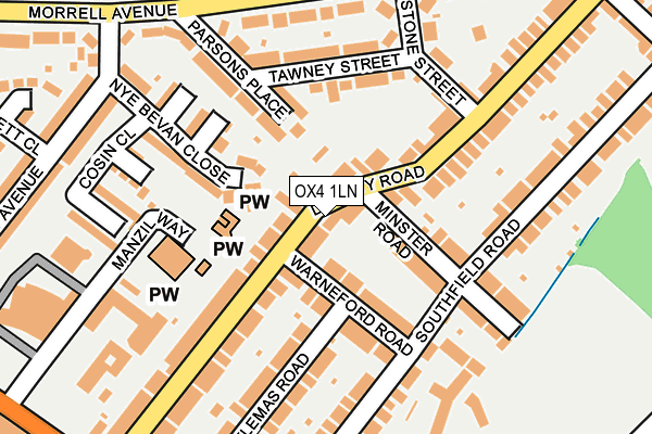
OX4 1LN lies on Divinity Road in Oxford. OX4 1LN is located in the St Clement's electoral ward, within the local authority district of Oxford and the English Parliamentary constituency of Oxford East. The Sub Integrated Care Board (ICB) Location is NHS Buckinghamshire, Oxfordshire and Berkshire West ICB - 10Q and the police force is Thames Valley. This postcode has been in use since January 1980.


GetTheData
Source: OS OpenMap – Local (Ordnance Survey)
Source: OS VectorMap District (Ordnance Survey)
Licence: Open Government Licence (requires attribution)
| Easting | 453346 |
| Northing | 205756 |
| Latitude | 51.747970 |
| Longitude | -1.228684 |
GetTheData
Source: Open Postcode Geo
Licence: Open Government Licence
| Street | Divinity Road |
| Town/City | Oxford |
| Country | England |
| Postcode District | OX4 |
➜ See where OX4 is on a map ➜ Where is Oxford? | |
GetTheData
Source: Land Registry Price Paid Data
Licence: Open Government Licence
Elevation or altitude of OX4 1LN as distance above sea level:
| Metres | Feet | |
|---|---|---|
| Elevation | 80m | 262ft |
Elevation is measured from the approximate centre of the postcode, to the nearest point on an OS contour line from OS Terrain 50, which has contour spacing of ten vertical metres.
➜ How high above sea level am I? Find the elevation of your current position using your device's GPS.
GetTheData
Source: Open Postcode Elevation
Licence: Open Government Licence
| Ward | St Clement's |
| Constituency | Oxford East |
GetTheData
Source: ONS Postcode Database
Licence: Open Government Licence
| Stone Street (Morrell Avenue) | Oxford | 215m |
| East Avenue (Morrell Avenue) | Oxford | 221m |
| Stone Street (Morrell Avenue) | Oxford | 240m |
| East Avenue (Morrell Avenue) | Oxford | 248m |
| Manzil Way (Cowley Road) | Oxford | 328m |
| Oxford Station | 2.9km |
GetTheData
Source: NaPTAN
Licence: Open Government Licence
| Percentage of properties with Next Generation Access | 100.0% |
| Percentage of properties with Superfast Broadband | 100.0% |
| Percentage of properties with Ultrafast Broadband | 91.7% |
| Percentage of properties with Full Fibre Broadband | 0.0% |
Superfast Broadband is between 30Mbps and 300Mbps
Ultrafast Broadband is > 300Mbps
| Median download speed | 100.0Mbps |
| Average download speed | 133.0Mbps |
| Maximum download speed | 350.00Mbps |
| Median upload speed | 17.5Mbps |
| Average upload speed | 11.8Mbps |
| Maximum upload speed | 20.00Mbps |
| Percentage of properties unable to receive 2Mbps | 0.0% |
| Percentage of properties unable to receive 5Mbps | 0.0% |
| Percentage of properties unable to receive 10Mbps | 0.0% |
| Percentage of properties unable to receive 30Mbps | 0.0% |
GetTheData
Source: Ofcom
Licence: Ofcom Terms of Use (requires attribution)
Estimated total energy consumption in OX4 1LN by fuel type, 2015.
| Consumption (kWh) | 497,448 |
|---|---|
| Meter count | 28 |
| Mean (kWh/meter) | 17,766 |
| Median (kWh/meter) | 16,245 |
| Consumption (kWh) | 149,524 |
|---|---|
| Meter count | 36 |
| Mean (kWh/meter) | 4,153 |
| Median (kWh/meter) | 4,014 |
GetTheData
Source: Postcode level gas estimates: 2015 (experimental)
Source: Postcode level electricity estimates: 2015 (experimental)
Licence: Open Government Licence
GetTheData
Source: ONS Postcode Database
Licence: Open Government Licence


➜ Get more ratings from the Food Standards Agency
GetTheData
Source: Food Standards Agency
Licence: FSA terms & conditions
| Last Collection | |||
|---|---|---|---|
| Location | Mon-Fri | Sat | Distance |
| Divinity Road | 17:00 | 11:45 | 48m |
| Morrell Avenue | 17:15 | 11:30 | 271m |
| Hill Top Road | 17:00 | 11:45 | 330m |
GetTheData
Source: Dracos
Licence: Creative Commons Attribution-ShareAlike
The below table lists the International Territorial Level (ITL) codes (formerly Nomenclature of Territorial Units for Statistics (NUTS) codes) and Local Administrative Units (LAU) codes for OX4 1LN:
| ITL 1 Code | Name |
|---|---|
| TLJ | South East (England) |
| ITL 2 Code | Name |
| TLJ1 | Berkshire, Buckinghamshire and Oxfordshire |
| ITL 3 Code | Name |
| TLJ14 | Oxfordshire CC |
| LAU 1 Code | Name |
| E07000178 | Oxford |
GetTheData
Source: ONS Postcode Directory
Licence: Open Government Licence
The below table lists the Census Output Area (OA), Lower Layer Super Output Area (LSOA), and Middle Layer Super Output Area (MSOA) for OX4 1LN:
| Code | Name | |
|---|---|---|
| OA | E00145594 | |
| LSOA | E01028581 | Oxford 011C |
| MSOA | E02005950 | Oxford 011 |
GetTheData
Source: ONS Postcode Directory
Licence: Open Government Licence
| OX4 1LT | Warneford Road | 53m |
| OX4 1LX | Minster Road | 90m |
| OX4 1LW | Divinity Road | 107m |
| OX4 1LU | Warneford Road | 113m |
| OX4 1GB | Nye Bevan Close | 122m |
| OX4 1BT | Parsons Place | 130m |
| OX4 1NL | Parsons Place | 137m |
| OX4 1NJ | Tawney Street | 153m |
| OX4 1LJ | Divinity Road | 164m |
| OX4 1LH | Divinity Road | 168m |
GetTheData
Source: Open Postcode Geo; Land Registry Price Paid Data
Licence: Open Government Licence