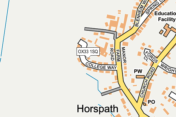
OX33 1SQ lies on College Way in Horspath, Oxford. OX33 1SQ is located in the Garsington & Horspath electoral ward, within the local authority district of South Oxfordshire and the English Parliamentary constituency of Henley. The Sub Integrated Care Board (ICB) Location is NHS Buckinghamshire, Oxfordshire and Berkshire West ICB - 10Q and the police force is Thames Valley. This postcode has been in use since August 1992.


GetTheData
Source: OS OpenMap – Local (Ordnance Survey)
Source: OS VectorMap District (Ordnance Survey)
Licence: Open Government Licence (requires attribution)
| Easting | 456963 |
| Northing | 204941 |
| Latitude | 51.740287 |
| Longitude | -1.176431 |
GetTheData
Source: Open Postcode Geo
Licence: Open Government Licence
| Street | College Way |
| Locality | Horspath |
| Town/City | Oxford |
| Country | England |
| Postcode District | OX33 |
➜ See where OX33 is on a map ➜ Where is Horspath? | |
GetTheData
Source: Land Registry Price Paid Data
Licence: Open Government Licence
Elevation or altitude of OX33 1SQ as distance above sea level:
| Metres | Feet | |
|---|---|---|
| Elevation | 90m | 295ft |
Elevation is measured from the approximate centre of the postcode, to the nearest point on an OS contour line from OS Terrain 50, which has contour spacing of ten vertical metres.
➜ How high above sea level am I? Find the elevation of your current position using your device's GPS.
GetTheData
Source: Open Postcode Elevation
Licence: Open Government Licence
| Ward | Garsington & Horspath |
| Constituency | Henley |
GetTheData
Source: ONS Postcode Database
Licence: Open Government Licence
| The Green (Cuddesdon Road) | Horspath | 320m |
| The Green (Cuddesdon Road) | Horspath | 365m |
| Gidley Way Bottom (Gidley Way) | Horspath | 525m |
| Gidley Way Bottom (Gidley Way) | Horspath | 530m |
| Butts Road (Gidley Way) | Horspath | 655m |
GetTheData
Source: NaPTAN
Licence: Open Government Licence
| Percentage of properties with Next Generation Access | 100.0% |
| Percentage of properties with Superfast Broadband | 100.0% |
| Percentage of properties with Ultrafast Broadband | 0.0% |
| Percentage of properties with Full Fibre Broadband | 0.0% |
Superfast Broadband is between 30Mbps and 300Mbps
Ultrafast Broadband is > 300Mbps
| Median download speed | 38.2Mbps |
| Average download speed | 34.1Mbps |
| Maximum download speed | 64.05Mbps |
| Median upload speed | 7.8Mbps |
| Average upload speed | 8.4Mbps |
| Maximum upload speed | 17.87Mbps |
| Percentage of properties unable to receive 2Mbps | 0.0% |
| Percentage of properties unable to receive 5Mbps | 0.0% |
| Percentage of properties unable to receive 10Mbps | 0.0% |
| Percentage of properties unable to receive 30Mbps | 0.0% |
GetTheData
Source: Ofcom
Licence: Ofcom Terms of Use (requires attribution)
Estimated total energy consumption in OX33 1SQ by fuel type, 2015.
| Consumption (kWh) | 343,783 |
|---|---|
| Meter count | 30 |
| Mean (kWh/meter) | 11,459 |
| Median (kWh/meter) | 11,090 |
| Consumption (kWh) | 115,323 |
|---|---|
| Meter count | 30 |
| Mean (kWh/meter) | 3,844 |
| Median (kWh/meter) | 3,547 |
GetTheData
Source: Postcode level gas estimates: 2015 (experimental)
Source: Postcode level electricity estimates: 2015 (experimental)
Licence: Open Government Licence
GetTheData
Source: ONS Postcode Database
Licence: Open Government Licence


➜ Get more ratings from the Food Standards Agency
GetTheData
Source: Food Standards Agency
Licence: FSA terms & conditions
| Last Collection | |||
|---|---|---|---|
| Location | Mon-Fri | Sat | Distance |
| Horspath Post Office | 16:45 | 10:00 | 252m |
| Blenhiem Way | 16:35 | 08:15 | 374m |
| Butts Road | 16:30 | 07:15 | 630m |
GetTheData
Source: Dracos
Licence: Creative Commons Attribution-ShareAlike
The below table lists the International Territorial Level (ITL) codes (formerly Nomenclature of Territorial Units for Statistics (NUTS) codes) and Local Administrative Units (LAU) codes for OX33 1SQ:
| ITL 1 Code | Name |
|---|---|
| TLJ | South East (England) |
| ITL 2 Code | Name |
| TLJ1 | Berkshire, Buckinghamshire and Oxfordshire |
| ITL 3 Code | Name |
| TLJ14 | Oxfordshire CC |
| LAU 1 Code | Name |
| E07000179 | South Oxfordshire |
GetTheData
Source: ONS Postcode Directory
Licence: Open Government Licence
The below table lists the Census Output Area (OA), Lower Layer Super Output Area (LSOA), and Middle Layer Super Output Area (MSOA) for OX33 1SQ:
| Code | Name | |
|---|---|---|
| OA | E00146083 | |
| LSOA | E01028683 | South Oxfordshire 002D |
| MSOA | E02005959 | South Oxfordshire 002 |
GetTheData
Source: ONS Postcode Directory
Licence: Open Government Licence
| OX33 1SD | Manor Farm Road | 86m |
| OX33 1SE | Manor Farm Road | 132m |
| OX33 1RX | Fords Close | 188m |
| OX33 1RU | Church Road | 231m |
| OX33 1SA | Spring Lane | 254m |
| OX33 1SB | Blenheim Way | 271m |
| OX33 1RP | The Green | 312m |
| OX33 1RR | Wrightson Close | 313m |
| OX33 1RT | Oxford Road | 330m |
| OX33 1RY | Blenheim Road | 363m |
GetTheData
Source: Open Postcode Geo; Land Registry Price Paid Data
Licence: Open Government Licence