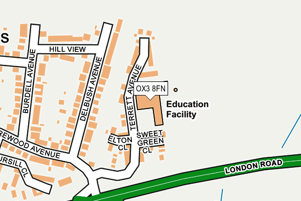
OX3 8FN is located in the Barton & Sandhills electoral ward, within the local authority district of Oxford and the English Parliamentary constituency of Oxford East. The Sub Integrated Care Board (ICB) Location is NHS Buckinghamshire, Oxfordshire and Berkshire West ICB - 10Q and the police force is Thames Valley. This postcode has been in use since January 2003.


GetTheData
Source: OS OpenMap – Local (Ordnance Survey)
Source: OS VectorMap District (Ordnance Survey)
Licence: Open Government Licence (requires attribution)
| Easting | 456664 |
| Northing | 207634 |
| Latitude | 51.764528 |
| Longitude | -1.180323 |
GetTheData
Source: Open Postcode Geo
Licence: Open Government Licence
| Country | England |
| Postcode District | OX3 |
➜ See where OX3 is on a map ➜ Where is Oxford? | |
GetTheData
Source: Land Registry Price Paid Data
Licence: Open Government Licence
Elevation or altitude of OX3 8FN as distance above sea level:
| Metres | Feet | |
|---|---|---|
| Elevation | 90m | 295ft |
Elevation is measured from the approximate centre of the postcode, to the nearest point on an OS contour line from OS Terrain 50, which has contour spacing of ten vertical metres.
➜ How high above sea level am I? Find the elevation of your current position using your device's GPS.
GetTheData
Source: Open Postcode Elevation
Licence: Open Government Licence
| Ward | Barton & Sandhills |
| Constituency | Oxford East |
GetTheData
Source: ONS Postcode Database
Licence: Open Government Licence
| Thornhill Park And Ride (A40 London Road) | Sandhills | 159m |
| Hill View (Burdell Avenue) | Sandhills | 252m |
| Burdell Avenue (Merewood Avenue) | Sandhills | 276m |
| Thornhill Park And Ride (Bus Terminal) | Thornhill | 289m |
| Thornhill Park And Ride (A40 London Road) | Sandhills | 314m |
GetTheData
Source: NaPTAN
Licence: Open Government Licence
GetTheData
Source: ONS Postcode Database
Licence: Open Government Licence


➜ Get more ratings from the Food Standards Agency
GetTheData
Source: Food Standards Agency
Licence: FSA terms & conditions
| Last Collection | |||
|---|---|---|---|
| Location | Mon-Fri | Sat | Distance |
| Merewood Avenue | 17:00 | 12:00 | 314m |
| Green Ridges | 17:00 | 12:00 | 499m |
| Humfrey Road | 17:00 | 12:00 | 699m |
GetTheData
Source: Dracos
Licence: Creative Commons Attribution-ShareAlike
The below table lists the International Territorial Level (ITL) codes (formerly Nomenclature of Territorial Units for Statistics (NUTS) codes) and Local Administrative Units (LAU) codes for OX3 8FN:
| ITL 1 Code | Name |
|---|---|
| TLJ | South East (England) |
| ITL 2 Code | Name |
| TLJ1 | Berkshire, Buckinghamshire and Oxfordshire |
| ITL 3 Code | Name |
| TLJ14 | Oxfordshire CC |
| LAU 1 Code | Name |
| E07000178 | Oxford |
GetTheData
Source: ONS Postcode Directory
Licence: Open Government Licence
The below table lists the Census Output Area (OA), Lower Layer Super Output Area (LSOA), and Middle Layer Super Output Area (MSOA) for OX3 8FN:
| Code | Name | |
|---|---|---|
| OA | E00145281 | |
| LSOA | E01028515 | Oxford 007A |
| MSOA | E02005946 | Oxford 007 |
GetTheData
Source: ONS Postcode Directory
Licence: Open Government Licence
| OX3 8FE | Terrett Avenue | 56m |
| OX3 8FR | Sweet Green Close | 95m |
| OX3 8EA | Delbush Avenue | 104m |
| OX3 8FF | Terrett Avenue | 112m |
| OX3 8FL | Elton Close | 118m |
| OX3 8DZ | Delbush Avenue | 145m |
| OX3 8EB | Hill View | 209m |
| OX3 8ED | Burdell Avenue | 226m |
| OX3 8EE | Burdell Avenue | 264m |
| OX3 8EG | Merewood Avenue | 302m |
GetTheData
Source: Open Postcode Geo; Land Registry Price Paid Data
Licence: Open Government Licence