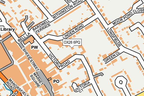
OX26 6PQ lies on Victoria Road in Bicester. OX26 6PQ is located in the Bicester East electoral ward, within the local authority district of Cherwell and the English Parliamentary constituency of Banbury. The Sub Integrated Care Board (ICB) Location is NHS Buckinghamshire, Oxfordshire and Berkshire West ICB - 10Q and the police force is Thames Valley. This postcode has been in use since October 2000.


GetTheData
Source: OS OpenMap – Local (Ordnance Survey)
Source: OS VectorMap District (Ordnance Survey)
Licence: Open Government Licence (requires attribution)
| Easting | 458644 |
| Northing | 222613 |
| Latitude | 51.898985 |
| Longitude | -1.149102 |
GetTheData
Source: Open Postcode Geo
Licence: Open Government Licence
| Street | Victoria Road |
| Town/City | Bicester |
| Country | England |
| Postcode District | OX26 |
➜ See where OX26 is on a map ➜ Where is Bicester? | |
GetTheData
Source: Land Registry Price Paid Data
Licence: Open Government Licence
Elevation or altitude of OX26 6PQ as distance above sea level:
| Metres | Feet | |
|---|---|---|
| Elevation | 70m | 230ft |
Elevation is measured from the approximate centre of the postcode, to the nearest point on an OS contour line from OS Terrain 50, which has contour spacing of ten vertical metres.
➜ How high above sea level am I? Find the elevation of your current position using your device's GPS.
GetTheData
Source: Open Postcode Elevation
Licence: Open Government Licence
| Ward | Bicester East |
| Constituency | Banbury |
GetTheData
Source: ONS Postcode Database
Licence: Open Government Licence
GREENWAY HOUSE, VICTORIA ROAD, BICESTER, OX26 6PQ 2007 21 AUG £420,000 |
GetTheData
Source: HM Land Registry Price Paid Data
Licence: Contains HM Land Registry data © Crown copyright and database right 2025. This data is licensed under the Open Government Licence v3.0.
| Manorsfield Road | Bicester Town Centre | 316m |
| Bicester North Railway Station (Buckingham Road) | Bicester | 528m |
| Bicester North Station (Buckingham Road) | Bicester | 536m |
| Bicester North Station (Buckingham Road) | Bicester | 538m |
| Queens Avenue | King's End | 539m |
| Bicester North Station | 0.5km |
| Bicester Village Station | 0.7km |
GetTheData
Source: NaPTAN
Licence: Open Government Licence
| Percentage of properties with Next Generation Access | 100.0% |
| Percentage of properties with Superfast Broadband | 100.0% |
| Percentage of properties with Ultrafast Broadband | 0.0% |
| Percentage of properties with Full Fibre Broadband | 0.0% |
Superfast Broadband is between 30Mbps and 300Mbps
Ultrafast Broadband is > 300Mbps
| Percentage of properties unable to receive 2Mbps | 0.0% |
| Percentage of properties unable to receive 5Mbps | 0.0% |
| Percentage of properties unable to receive 10Mbps | 0.0% |
| Percentage of properties unable to receive 30Mbps | 0.0% |
GetTheData
Source: Ofcom
Licence: Ofcom Terms of Use (requires attribution)
GetTheData
Source: ONS Postcode Database
Licence: Open Government Licence


➜ Get more ratings from the Food Standards Agency
GetTheData
Source: Food Standards Agency
Licence: FSA terms & conditions
| Last Collection | |||
|---|---|---|---|
| Location | Mon-Fri | Sat | Distance |
| Victoria Road | 17:00 | 11:00 | 56m |
| Tesco Store | 17:30 | 11:00 | 206m |
| Longfields | 17:30 | 11:00 | 227m |
GetTheData
Source: Dracos
Licence: Creative Commons Attribution-ShareAlike
The below table lists the International Territorial Level (ITL) codes (formerly Nomenclature of Territorial Units for Statistics (NUTS) codes) and Local Administrative Units (LAU) codes for OX26 6PQ:
| ITL 1 Code | Name |
|---|---|
| TLJ | South East (England) |
| ITL 2 Code | Name |
| TLJ1 | Berkshire, Buckinghamshire and Oxfordshire |
| ITL 3 Code | Name |
| TLJ14 | Oxfordshire CC |
| LAU 1 Code | Name |
| E07000177 | Cherwell |
GetTheData
Source: ONS Postcode Directory
Licence: Open Government Licence
The below table lists the Census Output Area (OA), Lower Layer Super Output Area (LSOA), and Middle Layer Super Output Area (MSOA) for OX26 6PQ:
| Code | Name | |
|---|---|---|
| OA | E00145050 | |
| LSOA | E01028467 | Cherwell 013E |
| MSOA | E02005933 | Cherwell 013 |
GetTheData
Source: ONS Postcode Directory
Licence: Open Government Licence
| OX26 6PR | Bath Terrace | 52m |
| OX26 6PJ | Victoria Road | 68m |
| OX26 6PG | Linden Road | 73m |
| OX26 6PT | Manchester Terrace | 82m |
| OX26 6PF | Linden Road | 95m |
| OX26 6PE | Linden Road | 113m |
| OX26 6PU | Newport Terrace | 119m |
| OX26 6PB | Victoria Road | 137m |
| OX26 6RR | Withington Road | 139m |
| OX26 6QU | Green Close | 145m |
GetTheData
Source: Open Postcode Geo; Land Registry Price Paid Data
Licence: Open Government Licence