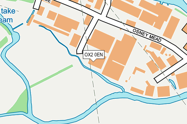
OX2 0EN is located in the Osney & St Thomas electoral ward, within the local authority district of Oxford and the English Parliamentary constituency of Oxford West and Abingdon. The Sub Integrated Care Board (ICB) Location is NHS Buckinghamshire, Oxfordshire and Berkshire West ICB - 10Q and the police force is Thames Valley. This postcode has been in use since August 1992.


GetTheData
Source: OS OpenMap – Local (Ordnance Survey)
Source: OS VectorMap District (Ordnance Survey)
Licence: Open Government Licence (requires attribution)
| Easting | 450115 |
| Northing | 205617 |
| Latitude | 51.747018 |
| Longitude | -1.275501 |
GetTheData
Source: Open Postcode Geo
Licence: Open Government Licence
| Country | England |
| Postcode District | OX2 |
➜ See where OX2 is on a map ➜ Where is Oxford? | |
GetTheData
Source: Land Registry Price Paid Data
Licence: Open Government Licence
Elevation or altitude of OX2 0EN as distance above sea level:
| Metres | Feet | |
|---|---|---|
| Elevation | 60m | 197ft |
Elevation is measured from the approximate centre of the postcode, to the nearest point on an OS contour line from OS Terrain 50, which has contour spacing of ten vertical metres.
➜ How high above sea level am I? Find the elevation of your current position using your device's GPS.
GetTheData
Source: Open Postcode Elevation
Licence: Open Government Licence
| Ward | Osney & St Thomas |
| Constituency | Oxford West And Abingdon |
GetTheData
Source: ONS Postcode Database
Licence: Open Government Licence
| Osney Island (Botley Road) | Oxford | 603m |
| Osney Island (Botley Road) | Oxford | 621m |
| Binsey Lane (Botley Road) | Oxford | 677m |
| St Lawrences Church (North Hinksey Lane) | North Hinksey | 696m |
| Binsey Lane (Botley Road) | Oxford | 696m |
| Oxford Station | 0.8km |
GetTheData
Source: NaPTAN
Licence: Open Government Licence
GetTheData
Source: ONS Postcode Database
Licence: Open Government Licence


➜ Get more ratings from the Food Standards Agency
GetTheData
Source: Food Standards Agency
Licence: FSA terms & conditions
| Last Collection | |||
|---|---|---|---|
| Location | Mon-Fri | Sat | Distance |
| Osney Mead | 17:30 | 12:00 | 166m |
| Bridge Street | 17:30 | 12:00 | 407m |
| North Hinksey | 17:00 | 12:00 | 592m |
GetTheData
Source: Dracos
Licence: Creative Commons Attribution-ShareAlike
The below table lists the International Territorial Level (ITL) codes (formerly Nomenclature of Territorial Units for Statistics (NUTS) codes) and Local Administrative Units (LAU) codes for OX2 0EN:
| ITL 1 Code | Name |
|---|---|
| TLJ | South East (England) |
| ITL 2 Code | Name |
| TLJ1 | Berkshire, Buckinghamshire and Oxfordshire |
| ITL 3 Code | Name |
| TLJ14 | Oxfordshire CC |
| LAU 1 Code | Name |
| E07000178 | Oxford |
GetTheData
Source: ONS Postcode Directory
Licence: Open Government Licence
The below table lists the Census Output Area (OA), Lower Layer Super Output Area (LSOA), and Middle Layer Super Output Area (MSOA) for OX2 0EN:
| Code | Name | |
|---|---|---|
| OA | E00145443 | |
| LSOA | E01028549 | Oxford 009B |
| MSOA | E02005948 | Oxford 009 |
GetTheData
Source: ONS Postcode Directory
Licence: Open Government Licence
| OX2 0ES | Osney Mead | 173m |
| OX2 0DP | Ferry Hinksey Road | 212m |
| OX2 0BG | Doyley Road | 330m |
| OX2 0BB | Bridge Street | 352m |
| OX2 0BE | South Street | 369m |
| OX2 0NP | West Street | 373m |
| OX2 0HJ | Mill Street | 392m |
| OX2 0BJ | Swan Street | 414m |
| OX2 0BH | West Street | 439m |
| OX2 0BQ | West Street | 450m |
GetTheData
Source: Open Postcode Geo; Land Registry Price Paid Data
Licence: Open Government Licence