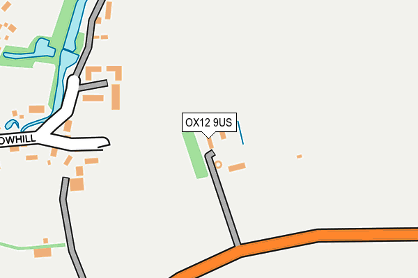
OX12 9US is located in the Ridgeway electoral ward, within the local authority district of Vale of White Horse and the English Parliamentary constituency of Wantage. The Sub Integrated Care Board (ICB) Location is NHS Buckinghamshire, Oxfordshire and Berkshire West ICB - 10Q and the police force is Thames Valley. This postcode has been in use since June 1997.


GetTheData
Source: OS OpenMap – Local (Ordnance Survey)
Source: OS VectorMap District (Ordnance Survey)
Licence: Open Government Licence (requires attribution)
| Easting | 436569 |
| Northing | 187391 |
| Latitude | 51.584196 |
| Longitude | -1.473602 |
GetTheData
Source: Open Postcode Geo
Licence: Open Government Licence
| Country | England |
| Postcode District | OX12 |
➜ See where OX12 is on a map | |
GetTheData
Source: Land Registry Price Paid Data
Licence: Open Government Licence
Elevation or altitude of OX12 9US as distance above sea level:
| Metres | Feet | |
|---|---|---|
| Elevation | 120m | 394ft |
Elevation is measured from the approximate centre of the postcode, to the nearest point on an OS contour line from OS Terrain 50, which has contour spacing of ten vertical metres.
➜ How high above sea level am I? Find the elevation of your current position using your device's GPS.
GetTheData
Source: Open Postcode Elevation
Licence: Open Government Licence
| Ward | Ridgeway |
| Constituency | Wantage |
GetTheData
Source: ONS Postcode Database
Licence: Open Government Licence
| The Hatchet Ph (High Street) | Childrey | 440m |
| Village Hall (High Street) | Childrey | 440m |
| The Hatchet Ph (High Street) | Childrey | 445m |
| Village Hall (High Street) | Childrey | 446m |
| Old School House (Silver Lane) | West Challow | 938m |
GetTheData
Source: NaPTAN
Licence: Open Government Licence
GetTheData
Source: ONS Postcode Database
Licence: Open Government Licence


➜ Get more ratings from the Food Standards Agency
GetTheData
Source: Food Standards Agency
Licence: FSA terms & conditions
| Last Collection | |||
|---|---|---|---|
| Location | Mon-Fri | Sat | Distance |
| Childrey | 16:15 | 09:30 | 419m |
| West Challow | 16:45 | 07:00 | 988m |
| Windmill Place | 16:45 | 08:00 | 1,460m |
GetTheData
Source: Dracos
Licence: Creative Commons Attribution-ShareAlike
The below table lists the International Territorial Level (ITL) codes (formerly Nomenclature of Territorial Units for Statistics (NUTS) codes) and Local Administrative Units (LAU) codes for OX12 9US:
| ITL 1 Code | Name |
|---|---|
| TLJ | South East (England) |
| ITL 2 Code | Name |
| TLJ1 | Berkshire, Buckinghamshire and Oxfordshire |
| ITL 3 Code | Name |
| TLJ14 | Oxfordshire CC |
| LAU 1 Code | Name |
| E07000180 | Vale of White Horse |
GetTheData
Source: ONS Postcode Directory
Licence: Open Government Licence
The below table lists the Census Output Area (OA), Lower Layer Super Output Area (LSOA), and Middle Layer Super Output Area (MSOA) for OX12 9US:
| Code | Name | |
|---|---|---|
| OA | E00146281 | |
| LSOA | E01028720 | Vale of White Horse 016G |
| MSOA | E02006886 | Vale of White Horse 016 |
GetTheData
Source: ONS Postcode Directory
Licence: Open Government Licence
| OX12 9XQ | Stowhill | 255m |
| OX12 9YR | Lawrence Close | 365m |
| OX12 9UU | Chapel Way | 385m |
| OX12 9UG | The Green | 435m |
| OX12 9UN | High Street | 437m |
| OX12 9UE | High Street | 437m |
| OX12 9UA | High Street | 442m |
| OX12 9UQ | High Street | 481m |
| OX12 9UW | Dog Lane | 498m |
| OX12 9UT | 509m |
GetTheData
Source: Open Postcode Geo; Land Registry Price Paid Data
Licence: Open Government Licence