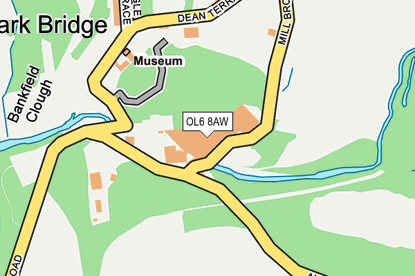
OL6 8AW is located in the Ashton Waterloo electoral ward, within the metropolitan district of Tameside and the English Parliamentary constituency of Ashton-under-Lyne. The Sub Integrated Care Board (ICB) Location is NHS Greater Manchester ICB - 01Y and the police force is Greater Manchester. This postcode has been in use since January 1980.


GetTheData
Source: OS OpenMap – Local (Ordnance Survey)
Source: OS VectorMap District (Ordnance Survey)
Licence: Open Government Licence (requires attribution)
| Easting | 394108 |
| Northing | 402368 |
| Latitude | 53.517952 |
| Longitude | -2.090330 |
GetTheData
Source: Open Postcode Geo
Licence: Open Government Licence
| Country | England |
| Postcode District | OL6 |
➜ See where OL6 is on a map ➜ Where is Park Bridge? | |
GetTheData
Source: Land Registry Price Paid Data
Licence: Open Government Licence
Elevation or altitude of OL6 8AW as distance above sea level:
| Metres | Feet | |
|---|---|---|
| Elevation | 130m | 427ft |
Elevation is measured from the approximate centre of the postcode, to the nearest point on an OS contour line from OS Terrain 50, which has contour spacing of ten vertical metres.
➜ How high above sea level am I? Find the elevation of your current position using your device's GPS.
GetTheData
Source: Open Postcode Elevation
Licence: Open Government Licence
| Ward | Ashton Waterloo |
| Constituency | Ashton-under-lyne |
GetTheData
Source: ONS Postcode Database
Licence: Open Government Licence
| Rosary Rd/Education Ctr (Rosary Rd) | Fitton Hill | 662m |
| Rosary Rd/Springwood Hall Rd (Rosary Rd) | Fitton Hill | 690m |
| Fircroft Rd/St Martins Rd (Fircroft Rd) | Fitton Hill | 728m |
| Springwood Hall Rd/Bungalows (Springwood Hall) | Fitton Hill | 747m |
| Fircroft Rd/Fold View (Fircroft Rd) | Fitton Hill | 748m |
| Ashton-under-Lyne Station | 3km |
| Mossley (Manchester) Station | 3.3km |
| Stalybridge Station | 4.1km |
GetTheData
Source: NaPTAN
Licence: Open Government Licence
GetTheData
Source: ONS Postcode Database
Licence: Open Government Licence


➜ Get more ratings from the Food Standards Agency
GetTheData
Source: Food Standards Agency
Licence: FSA terms & conditions
| Last Collection | |||
|---|---|---|---|
| Location | Mon-Fri | Sat | Distance |
| Lees Road P.o. | 17:30 | 12:05 | 349m |
| Higher Hurst Tso | 17:30 | 11:40 | 2,053m |
| 27 Broadbent Avenue | 17:00 | 11:00 | 2,062m |
GetTheData
Source: Dracos
Licence: Creative Commons Attribution-ShareAlike
The below table lists the International Territorial Level (ITL) codes (formerly Nomenclature of Territorial Units for Statistics (NUTS) codes) and Local Administrative Units (LAU) codes for OL6 8AW:
| ITL 1 Code | Name |
|---|---|
| TLD | North West (England) |
| ITL 2 Code | Name |
| TLD3 | Greater Manchester |
| ITL 3 Code | Name |
| TLD35 | Greater Manchester South East |
| LAU 1 Code | Name |
| E08000008 | Tameside |
GetTheData
Source: ONS Postcode Directory
Licence: Open Government Licence
The below table lists the Census Output Area (OA), Lower Layer Super Output Area (LSOA), and Middle Layer Super Output Area (MSOA) for OL6 8AW:
| Code | Name | |
|---|---|---|
| OA | E00030052 | |
| LSOA | E01005938 | Tameside 002A |
| MSOA | E02001230 | Tameside 002 |
GetTheData
Source: ONS Postcode Directory
Licence: Open Government Licence
| OL6 8AJ | Parkbridge | 153m |
| OL6 8AN | Parkbridge | 178m |
| OL6 8AH | Dingle Terrace | 230m |
| OL6 8AL | Dean Terrace | 260m |
| OL6 8AA | Lower Alt Hill | 442m |
| OL6 8AB | Lower Alt Hill | 473m |
| OL8 2HF | Ten Houses | 544m |
| OL6 8AD | Briaracre Terrace | 546m |
| OL8 2HE | Alt Lane | 549m |
| OL6 8AP | Alt Hill Lane | 600m |
GetTheData
Source: Open Postcode Geo; Land Registry Price Paid Data
Licence: Open Government Licence