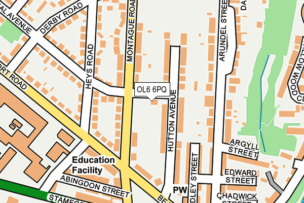
OL6 6PQ lies on Douglas Street in Ashton-under-lyne. OL6 6PQ is located in the Ashton St Michael's electoral ward, within the metropolitan district of Tameside and the English Parliamentary constituency of Ashton-under-Lyne. The Sub Integrated Care Board (ICB) Location is NHS Greater Manchester ICB - 01Y and the police force is Greater Manchester. This postcode has been in use since January 1980.


GetTheData
Source: OS OpenMap – Local (Ordnance Survey)
Source: OS VectorMap District (Ordnance Survey)
Licence: Open Government Licence (requires attribution)
| Easting | 394997 |
| Northing | 399113 |
| Latitude | 53.488704 |
| Longitude | -2.076869 |
GetTheData
Source: Open Postcode Geo
Licence: Open Government Licence
| Street | Douglas Street |
| Town/City | Ashton-under-lyne |
| Country | England |
| Postcode District | OL6 |
➜ See where OL6 is on a map ➜ Where is Ashton-under-Lyne? | |
GetTheData
Source: Land Registry Price Paid Data
Licence: Open Government Licence
Elevation or altitude of OL6 6PQ as distance above sea level:
| Metres | Feet | |
|---|---|---|
| Elevation | 130m | 427ft |
Elevation is measured from the approximate centre of the postcode, to the nearest point on an OS contour line from OS Terrain 50, which has contour spacing of ten vertical metres.
➜ How high above sea level am I? Find the elevation of your current position using your device's GPS.
GetTheData
Source: Open Postcode Elevation
Licence: Open Government Licence
| Ward | Ashton St Michael's |
| Constituency | Ashton-under-lyne |
GetTheData
Source: ONS Postcode Database
Licence: Open Government Licence
| Montague Rd/Beaufort Rd (Montague Rd) | Cockbrook | 75m |
| Montague Rd/Beaufort Rd (Montague Rd) | Cockbrook | 86m |
| Beaufort Rd/Heys Rd (Beaufort Rd) | Cockbrook | 134m |
| Beaufort Rd/Heys Rd (Beaufort Rd) | Cockbrook | 177m |
| Stamford St/Granville St (Stamford St) | Cockbrook | 250m |
| Ashton-under-lyne (Manchester Metrolink) (Wellington Rd) | Ashton Under Lyne | 1,416m |
| Stalybridge Station | 1km |
| Ashton-under-Lyne Station | 1.2km |
| Hyde North Station | 2.7km |
GetTheData
Source: NaPTAN
Licence: Open Government Licence
| Percentage of properties with Next Generation Access | 100.0% |
| Percentage of properties with Superfast Broadband | 100.0% |
| Percentage of properties with Ultrafast Broadband | 80.0% |
| Percentage of properties with Full Fibre Broadband | 0.0% |
Superfast Broadband is between 30Mbps and 300Mbps
Ultrafast Broadband is > 300Mbps
| Percentage of properties unable to receive 2Mbps | 0.0% |
| Percentage of properties unable to receive 5Mbps | 0.0% |
| Percentage of properties unable to receive 10Mbps | 0.0% |
| Percentage of properties unable to receive 30Mbps | 0.0% |
GetTheData
Source: Ofcom
Licence: Ofcom Terms of Use (requires attribution)
GetTheData
Source: ONS Postcode Database
Licence: Open Government Licence


➜ Get more ratings from the Food Standards Agency
GetTheData
Source: Food Standards Agency
Licence: FSA terms & conditions
| Last Collection | |||
|---|---|---|---|
| Location | Mon-Fri | Sat | Distance |
| Stamford Park | 17:30 | 11:20 | 361m |
| Mossley Road P.o. | 17:30 | 11:30 | 451m |
| Grafton Street | 17:30 | 11:25 | 460m |
GetTheData
Source: Dracos
Licence: Creative Commons Attribution-ShareAlike
The below table lists the International Territorial Level (ITL) codes (formerly Nomenclature of Territorial Units for Statistics (NUTS) codes) and Local Administrative Units (LAU) codes for OL6 6PQ:
| ITL 1 Code | Name |
|---|---|
| TLD | North West (England) |
| ITL 2 Code | Name |
| TLD3 | Greater Manchester |
| ITL 3 Code | Name |
| TLD35 | Greater Manchester South East |
| LAU 1 Code | Name |
| E08000008 | Tameside |
GetTheData
Source: ONS Postcode Directory
Licence: Open Government Licence
The below table lists the Census Output Area (OA), Lower Layer Super Output Area (LSOA), and Middle Layer Super Output Area (MSOA) for OL6 6PQ:
| Code | Name | |
|---|---|---|
| OA | E00030099 | |
| LSOA | E01005942 | Tameside 007B |
| MSOA | E02001235 | Tameside 007 |
GetTheData
Source: ONS Postcode Directory
Licence: Open Government Licence
| OL6 6PH | Montague Road | 85m |
| OL6 6QZ | Hutton Avenue | 95m |
| OL6 6QY | Hutton Avenue | 96m |
| OL6 6NZ | Heys Road | 117m |
| OL6 6RG | Arundel Street | 138m |
| OL6 6RH | Arundel Street | 148m |
| OL6 6PJ | Beaufort Road | 154m |
| OL6 6RB | Audley Street | 166m |
| OL6 6PL | Montague Road | 170m |
| OL6 6PW | Montague Road | 170m |
GetTheData
Source: Open Postcode Geo; Land Registry Price Paid Data
Licence: Open Government Licence