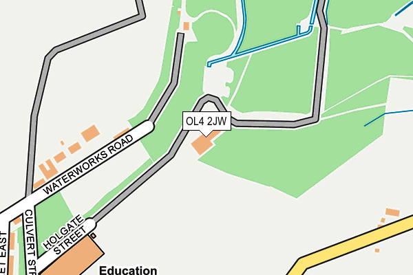
OL4 2JW lies on Holgate Street in Oldham. OL4 2JW is located in the Saddleworth North electoral ward, within the metropolitan district of Oldham and the English Parliamentary constituency of Oldham East and Saddleworth. The Sub Integrated Care Board (ICB) Location is NHS Greater Manchester ICB - 00Y and the police force is Greater Manchester. This postcode has been in use since June 2000.


GetTheData
Source: OS OpenMap – Local (Ordnance Survey)
Source: OS VectorMap District (Ordnance Survey)
Licence: Open Government Licence (requires attribution)
| Easting | 395796 |
| Northing | 406490 |
| Latitude | 53.555035 |
| Longitude | -2.064927 |
GetTheData
Source: Open Postcode Geo
Licence: Open Government Licence
| Street | Holgate Street |
| Town/City | Oldham |
| Country | England |
| Postcode District | OL4 |
➜ See where OL4 is on a map | |
GetTheData
Source: Land Registry Price Paid Data
Licence: Open Government Licence
Elevation or altitude of OL4 2JW as distance above sea level:
| Metres | Feet | |
|---|---|---|
| Elevation | 220m | 722ft |
Elevation is measured from the approximate centre of the postcode, to the nearest point on an OS contour line from OS Terrain 50, which has contour spacing of ten vertical metres.
➜ How high above sea level am I? Find the elevation of your current position using your device's GPS.
GetTheData
Source: Open Postcode Elevation
Licence: Open Government Licence
| Ward | Saddleworth North |
| Constituency | Oldham East And Saddleworth |
GetTheData
Source: ONS Postcode Database
Licence: Open Government Licence
| Huddersfield Rd/Waterhead Academy (Huddersfield Rd) | Waterhead | 728m |
| Huddersfield Rd/Waterhead Academy (Huddersfield Rd) | Waterhead | 736m |
| Huddersfield Rd/Waterhead Academy (Huddersfield Rd) | Waterhead | 744m |
| Huddersfield Rd/Waterhead Academy (Huddersfield Rd) | Waterhead | 753m |
| Culvert St/Waterhead Terminus (Huddersfield Rd) | Waterhead | 758m |
| Greenfield Station | 3.8km |
| Mossley (Manchester) Station | 4.7km |
GetTheData
Source: NaPTAN
Licence: Open Government Licence
GetTheData
Source: ONS Postcode Database
Licence: Open Government Licence


➜ Get more ratings from the Food Standards Agency
GetTheData
Source: Food Standards Agency
Licence: FSA terms & conditions
| Last Collection | |||
|---|---|---|---|
| Location | Mon-Fri | Sat | Distance |
| Mossgate | 17:10 | 11:30 | 748m |
| Moorside P.o. | 17:30 | 11:30 | 1,037m |
| Strinesdale | 17:15 | 11:35 | 1,085m |
GetTheData
Source: Dracos
Licence: Creative Commons Attribution-ShareAlike
The below table lists the International Territorial Level (ITL) codes (formerly Nomenclature of Territorial Units for Statistics (NUTS) codes) and Local Administrative Units (LAU) codes for OL4 2JW:
| ITL 1 Code | Name |
|---|---|
| TLD | North West (England) |
| ITL 2 Code | Name |
| TLD3 | Greater Manchester |
| ITL 3 Code | Name |
| TLD37 | Greater Manchester North East |
| LAU 1 Code | Name |
| E08000004 | Oldham |
GetTheData
Source: ONS Postcode Directory
Licence: Open Government Licence
The below table lists the Census Output Area (OA), Lower Layer Super Output Area (LSOA), and Middle Layer Super Output Area (MSOA) for OL4 2JW:
| Code | Name | |
|---|---|---|
| OA | E00027431 | |
| LSOA | E01005417 | Oldham 013D |
| MSOA | E02001110 | Oldham 013 |
GetTheData
Source: ONS Postcode Directory
Licence: Open Government Licence
| OL4 2JJ | Waterworks Road | 314m |
| OL4 3SG | Hollins Road | 373m |
| OL4 3SF | Top Oth'meadows | 422m |
| OL4 3SE | Brighton Road | 535m |
| OL4 2JL | Waterworks Road | 569m |
| OL4 2SL | Highmoor View | 627m |
| OL4 3PH | New Royd Avenue | 637m |
| OL4 2JB | Locking Gate Rise | 649m |
| OL4 3PQ | Hollins Avenue | 660m |
| OL4 3NZ | Sloane Avenue | 677m |
GetTheData
Source: Open Postcode Geo; Land Registry Price Paid Data
Licence: Open Government Licence