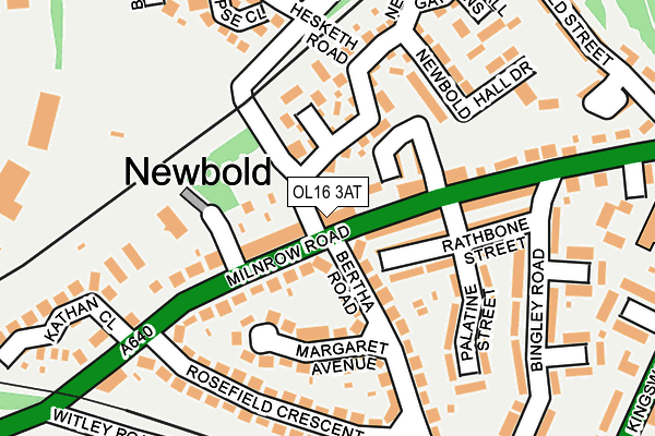
OL16 3AT lies on Hyde Park Mews in Rochdale. OL16 3AT is located in the Kingsway electoral ward, within the metropolitan district of Rochdale and the English Parliamentary constituency of Rochdale. The Sub Integrated Care Board (ICB) Location is NHS Greater Manchester ICB - 01D and the police force is Greater Manchester. This postcode has been in use since May 2013.


GetTheData
Source: OS OpenMap – Local (Ordnance Survey)
Source: OS VectorMap District (Ordnance Survey)
Licence: Open Government Licence (requires attribution)
| Easting | 391125 |
| Northing | 413230 |
| Latitude | 53.615556 |
| Longitude | -2.135629 |
GetTheData
Source: Open Postcode Geo
Licence: Open Government Licence
| Street | Hyde Park Mews |
| Town/City | Rochdale |
| Country | England |
| Postcode District | OL16 |
➜ See where OL16 is on a map ➜ Where is Rochdale? | |
GetTheData
Source: Land Registry Price Paid Data
Licence: Open Government Licence
Elevation or altitude of OL16 3AT as distance above sea level:
| Metres | Feet | |
|---|---|---|
| Elevation | 140m | 459ft |
Elevation is measured from the approximate centre of the postcode, to the nearest point on an OS contour line from OS Terrain 50, which has contour spacing of ten vertical metres.
➜ How high above sea level am I? Find the elevation of your current position using your device's GPS.
GetTheData
Source: Open Postcode Elevation
Licence: Open Government Licence
| Ward | Kingsway |
| Constituency | Rochdale |
GetTheData
Source: ONS Postcode Database
Licence: Open Government Licence
| Milnrow Rd/Palatine St (Milnrow Rd) | Newbold | 55m |
| Milnrow Rd/Palatine St (Milnrow Rd) | Newbold | 80m |
| Milnrow Rd/Marshall St (Milnrow Rd) | Newbold | 90m |
| Milnrow Rd/Rosefield Cres (Milnrow Rd) | Newbold | 181m |
| Croxton Avenue/Eclipse Close (Croxton Avenue) | Newbold | 280m |
| Newbold (Manchester Metrolink) (Kingsway) | Newbold | 242m |
| Kingsway Business Park (Manchester Metrolink) (Leyfield Road) | Milnrow | 922m |
| Rochdale Interchange (Manchester Metrolink) (Smith Street) | Rochdale | 1,317m |
| Rochdale Railway Station (Manchester Metrolink) (Maclure Rd) | Rochdale | 1,343m |
| Rochdale Station | 1.3km |
| Smithy Bridge Station | 2.5km |
| Castleton (Manchester) Station | 3.9km |
GetTheData
Source: NaPTAN
Licence: Open Government Licence
| Percentage of properties with Next Generation Access | 100.0% |
| Percentage of properties with Superfast Broadband | 100.0% |
| Percentage of properties with Ultrafast Broadband | 0.0% |
| Percentage of properties with Full Fibre Broadband | 0.0% |
Superfast Broadband is between 30Mbps and 300Mbps
Ultrafast Broadband is > 300Mbps
| Percentage of properties unable to receive 2Mbps | 0.0% |
| Percentage of properties unable to receive 5Mbps | 0.0% |
| Percentage of properties unable to receive 10Mbps | 0.0% |
| Percentage of properties unable to receive 30Mbps | 0.0% |
GetTheData
Source: Ofcom
Licence: Ofcom Terms of Use (requires attribution)
GetTheData
Source: ONS Postcode Database
Licence: Open Government Licence

➜ Get more ratings from the Food Standards Agency
GetTheData
Source: Food Standards Agency
Licence: FSA terms & conditions
| Last Collection | |||
|---|---|---|---|
| Location | Mon-Fri | Sat | Distance |
| Belfield P.o. | 18:15 | 11:30 | 667m |
| Rochdale Delivery Office | 961m | ||
| Rochdale Delivery Office | 19:00 | 11:45 | 974m |
GetTheData
Source: Dracos
Licence: Creative Commons Attribution-ShareAlike
The below table lists the International Territorial Level (ITL) codes (formerly Nomenclature of Territorial Units for Statistics (NUTS) codes) and Local Administrative Units (LAU) codes for OL16 3AT:
| ITL 1 Code | Name |
|---|---|
| TLD | North West (England) |
| ITL 2 Code | Name |
| TLD3 | Greater Manchester |
| ITL 3 Code | Name |
| TLD37 | Greater Manchester North East |
| LAU 1 Code | Name |
| E08000005 | Rochdale |
GetTheData
Source: ONS Postcode Directory
Licence: Open Government Licence
The below table lists the Census Output Area (OA), Lower Layer Super Output Area (LSOA), and Middle Layer Super Output Area (MSOA) for OL16 3AT:
| Code | Name | |
|---|---|---|
| OA | E00172361 | |
| LSOA | E01005566 | Rochdale 012D |
| MSOA | E02001143 | Rochdale 012 |
GetTheData
Source: ONS Postcode Directory
Licence: Open Government Licence
| OL16 5AY | Hyde Park Place | 28m |
| OL16 5AX | Kenworthy Terrace | 88m |
| OL16 5BA | Milnrow Road | 102m |
| OL16 5AS | Milnrow Road | 102m |
| OL16 5AT | Kenworthy Street | 103m |
| OL16 3AG | Newbold Hall Drive | 110m |
| OL16 5BG | Margaret Avenue | 111m |
| OL16 5BH | Rathbone Street | 120m |
| OL16 5BB | Milnrow Road | 125m |
| OL16 5BQ | Milnrow Road | 128m |
GetTheData
Source: Open Postcode Geo; Land Registry Price Paid Data
Licence: Open Government Licence