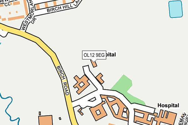
OL12 9EG lies on Birch Road in Wardle, Rochdale. OL12 9EG is located in the Wardle, Shore & West Littleborough electoral ward, within the metropolitan district of Rochdale and the English Parliamentary constituency of Rochdale. The Sub Integrated Care Board (ICB) Location is NHS Greater Manchester ICB - 01D and the police force is Greater Manchester. This postcode has been in use since June 2003.


GetTheData
Source: OS OpenMap – Local (Ordnance Survey)
Source: OS VectorMap District (Ordnance Survey)
Licence: Open Government Licence (requires attribution)
| Easting | 391738 |
| Northing | 416438 |
| Latitude | 53.644384 |
| Longitude | -2.126450 |
GetTheData
Source: Open Postcode Geo
Licence: Open Government Licence
| Street | Birch Road |
| Locality | Wardle |
| Town/City | Rochdale |
| Country | England |
| Postcode District | OL12 |
➜ See where OL12 is on a map ➜ Where is Rochdale? | |
GetTheData
Source: Land Registry Price Paid Data
Licence: Open Government Licence
Elevation or altitude of OL12 9EG as distance above sea level:
| Metres | Feet | |
|---|---|---|
| Elevation | 190m | 623ft |
Elevation is measured from the approximate centre of the postcode, to the nearest point on an OS contour line from OS Terrain 50, which has contour spacing of ten vertical metres.
➜ How high above sea level am I? Find the elevation of your current position using your device's GPS.
GetTheData
Source: Open Postcode Elevation
Licence: Open Government Licence
| Ward | Wardle, Shore & West Littleborough |
| Constituency | Rochdale |
GetTheData
Source: ONS Postcode Database
Licence: Open Government Licence
BIRCH LODGE, BIRCH ROAD, WARDLE, ROCHDALE, OL12 9EG 2002 1 MAR £50,000 |
GetTheData
Source: HM Land Registry Price Paid Data
Licence: Contains HM Land Registry data © Crown copyright and database right 2025. This data is licensed under the Open Government Licence v3.0.
| Birch Rd/Birch Hill Hospital (Birch Rd) | Wardle | 123m |
| Birch Rd/Wardle Hs (Birch Rd) | Wardle | 220m |
| Birch Rd/Wardle H.s. (Birch Road) | Wardle | 280m |
| Birch Road/Waterhouse Cl (Birch Road) | Wardle | 283m |
| Birch Rd/Waterhouse Cl (Birch Rd) | Wardle | 320m |
| Smithy Bridge Station | 1.5km |
| Littleborough Station | 2.1km |
| Rochdale Station | 4.2km |
GetTheData
Source: NaPTAN
Licence: Open Government Licence
| Percentage of properties with Next Generation Access | 100.0% |
| Percentage of properties with Superfast Broadband | 100.0% |
| Percentage of properties with Ultrafast Broadband | 0.0% |
| Percentage of properties with Full Fibre Broadband | 0.0% |
Superfast Broadband is between 30Mbps and 300Mbps
Ultrafast Broadband is > 300Mbps
| Percentage of properties unable to receive 2Mbps | 0.0% |
| Percentage of properties unable to receive 5Mbps | 0.0% |
| Percentage of properties unable to receive 10Mbps | 0.0% |
| Percentage of properties unable to receive 30Mbps | 0.0% |
GetTheData
Source: Ofcom
Licence: Ofcom Terms of Use (requires attribution)
GetTheData
Source: ONS Postcode Database
Licence: Open Government Licence


➜ Get more ratings from the Food Standards Agency
GetTheData
Source: Food Standards Agency
Licence: FSA terms & conditions
| Last Collection | |||
|---|---|---|---|
| Location | Mon-Fri | Sat | Distance |
| Dearnley P.o. | 18:30 | 11:30 | 888m |
| Bents Farm | 17:00 | 11:00 | 912m |
| Lightburn | 17:00 | 11:00 | 990m |
GetTheData
Source: Dracos
Licence: Creative Commons Attribution-ShareAlike
The below table lists the International Territorial Level (ITL) codes (formerly Nomenclature of Territorial Units for Statistics (NUTS) codes) and Local Administrative Units (LAU) codes for OL12 9EG:
| ITL 1 Code | Name |
|---|---|
| TLD | North West (England) |
| ITL 2 Code | Name |
| TLD3 | Greater Manchester |
| ITL 3 Code | Name |
| TLD37 | Greater Manchester North East |
| LAU 1 Code | Name |
| E08000005 | Rochdale |
GetTheData
Source: ONS Postcode Directory
Licence: Open Government Licence
The below table lists the Census Output Area (OA), Lower Layer Super Output Area (LSOA), and Middle Layer Super Output Area (MSOA) for OL12 9EG:
| Code | Name | |
|---|---|---|
| OA | E00028326 | |
| LSOA | E01005597 | Rochdale 002C |
| MSOA | E02001133 | Rochdale 002 |
GetTheData
Source: ONS Postcode Directory
Licence: Open Government Licence
| OL12 9RL | Fleming Close | 252m |
| OL12 9LS | Shaftesbury Drive | 282m |
| OL12 9LX | Birch Road | 284m |
| OL12 9LN | Westmorland Drive | 287m |
| OL12 9RJ | Floyd Close | 288m |
| OL12 9LT | Shaftesbury Drive | 299m |
| OL12 9LU | Ashbourne Close | 317m |
| OL12 9SR | John Elliot Close | 338m |
| OL12 9LP | Hibson Close | 349m |
| OL12 9RN | Beadle Avenue | 357m |
GetTheData
Source: Open Postcode Geo; Land Registry Price Paid Data
Licence: Open Government Licence