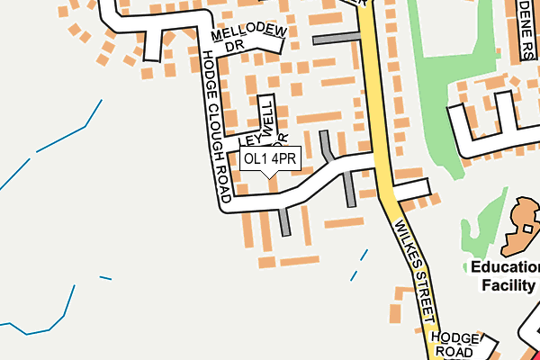
OL1 4PR is located in the St James' electoral ward, within the metropolitan district of Oldham and the English Parliamentary constituency of Oldham East and Saddleworth. The Sub Integrated Care Board (ICB) Location is NHS Greater Manchester ICB - 00Y and the police force is Greater Manchester. This postcode has been in use since January 1980.


GetTheData
Source: OS OpenMap – Local (Ordnance Survey)
Source: OS VectorMap District (Ordnance Survey)
Licence: Open Government Licence (requires attribution)
| Easting | 394689 |
| Northing | 407359 |
| Latitude | 53.562819 |
| Longitude | -2.081654 |
GetTheData
Source: Open Postcode Geo
Licence: Open Government Licence
| Country | England |
| Postcode District | OL1 |
➜ See where OL1 is on a map ➜ Where is Oldham? | |
GetTheData
Source: Land Registry Price Paid Data
Licence: Open Government Licence
Elevation or altitude of OL1 4PR as distance above sea level:
| Metres | Feet | |
|---|---|---|
| Elevation | 240m | 787ft |
Elevation is measured from the approximate centre of the postcode, to the nearest point on an OS contour line from OS Terrain 50, which has contour spacing of ten vertical metres.
➜ How high above sea level am I? Find the elevation of your current position using your device's GPS.
GetTheData
Source: Open Postcode Elevation
Licence: Open Government Licence
| Ward | St James' |
| Constituency | Oldham East And Saddleworth |
GetTheData
Source: ONS Postcode Database
Licence: Open Government Licence
| Sholver Ln/Wilkes St (Sholver Ln) | Sholver | 258m |
| Sholver Ln/Wilkes St (Sholver Ln) | Sholver | 272m |
| Pearly Bank/Sholver Terminus (Pearly Bank) | Sholver | 360m |
| Ripponden Rd/Alexandra Terrace (Ripponden Rd) | Moorside | 367m |
| Ripponden Rd/Turf Pit Ln (Ripponden Rd) | Moorside | 384m |
| Shaw And Crompton (Manchester Metrolink) (Beal Lane) | Shaw | 1,572m |
| Derker (Manchester Metrolink) (Yates Street) | Derker | 1,961m |
| Greenfield Station | 5.2km |
GetTheData
Source: NaPTAN
Licence: Open Government Licence
| Percentage of properties with Next Generation Access | 100.0% |
| Percentage of properties with Superfast Broadband | 100.0% |
| Percentage of properties with Ultrafast Broadband | 100.0% |
| Percentage of properties with Full Fibre Broadband | 0.0% |
Superfast Broadband is between 30Mbps and 300Mbps
Ultrafast Broadband is > 300Mbps
| Percentage of properties unable to receive 2Mbps | 0.0% |
| Percentage of properties unable to receive 5Mbps | 0.0% |
| Percentage of properties unable to receive 10Mbps | 0.0% |
| Percentage of properties unable to receive 30Mbps | 0.0% |
GetTheData
Source: Ofcom
Licence: Ofcom Terms of Use (requires attribution)
GetTheData
Source: ONS Postcode Database
Licence: Open Government Licence


➜ Get more ratings from the Food Standards Agency
GetTheData
Source: Food Standards Agency
Licence: FSA terms & conditions
| Last Collection | |||
|---|---|---|---|
| Location | Mon-Fri | Sat | Distance |
| Royal Oldham Hospital | 17:25 | 11:15 | 255m |
| Moorside P.o. | 17:30 | 11:30 | 392m |
| Mossgate | 17:10 | 11:30 | 813m |
GetTheData
Source: Dracos
Licence: Creative Commons Attribution-ShareAlike
The below table lists the International Territorial Level (ITL) codes (formerly Nomenclature of Territorial Units for Statistics (NUTS) codes) and Local Administrative Units (LAU) codes for OL1 4PR:
| ITL 1 Code | Name |
|---|---|
| TLD | North West (England) |
| ITL 2 Code | Name |
| TLD3 | Greater Manchester |
| ITL 3 Code | Name |
| TLD37 | Greater Manchester North East |
| LAU 1 Code | Name |
| E08000004 | Oldham |
GetTheData
Source: ONS Postcode Directory
Licence: Open Government Licence
The below table lists the Census Output Area (OA), Lower Layer Super Output Area (LSOA), and Middle Layer Super Output Area (MSOA) for OL1 4PR:
| Code | Name | |
|---|---|---|
| OA | E00027457 | |
| LSOA | E01032559 | Oldham 007F |
| MSOA | E02001104 | Oldham 007 |
GetTheData
Source: ONS Postcode Directory
Licence: Open Government Licence
| OL1 4PZ | Everdingen Walk | 59m |
| OL1 4PS | Belvedere Rise | 59m |
| OL1 4QA | Leywell Drive | 67m |
| OL1 4PY | Angelico Rise | 75m |
| OL1 4PE | Wilkes Street | 113m |
| OL1 4PL | Hodge Clough Road | 116m |
| OL1 4QE | Mellodew Drive | 137m |
| OL1 4PW | Hodge Clough Road | 142m |
| OL1 4JW | Wilkes Street | 147m |
| OL1 4PT | Goya Rise | 151m |
GetTheData
Source: Open Postcode Geo; Land Registry Price Paid Data
Licence: Open Government Licence