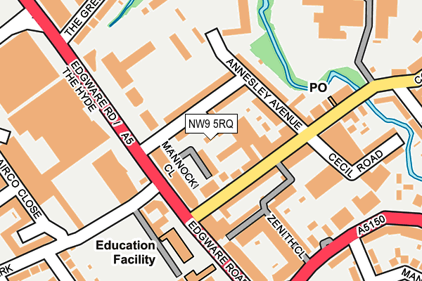
NW9 5RQ is located in the Colindale South electoral ward, within the London borough of Barnet and the English Parliamentary constituency of Hendon. The Sub Integrated Care Board (ICB) Location is NHS North Central London ICB - 93C and the police force is Metropolitan Police. This postcode has been in use since December 1998.


GetTheData
Source: OS OpenMap – Local (Ordnance Survey)
Source: OS VectorMap District (Ordnance Survey)
Licence: Open Government Licence (requires attribution)
| Easting | 520850 |
| Northing | 189708 |
| Latitude | 51.593270 |
| Longitude | -0.256762 |
GetTheData
Source: Open Postcode Geo
Licence: Open Government Licence
| Country | England |
| Postcode District | NW9 |
➜ See where NW9 is on a map ➜ Where is London? | |
GetTheData
Source: Land Registry Price Paid Data
Licence: Open Government Licence
Elevation or altitude of NW9 5RQ as distance above sea level:
| Metres | Feet | |
|---|---|---|
| Elevation | 50m | 164ft |
Elevation is measured from the approximate centre of the postcode, to the nearest point on an OS contour line from OS Terrain 50, which has contour spacing of ten vertical metres.
➜ How high above sea level am I? Find the elevation of your current position using your device's GPS.
GetTheData
Source: Open Postcode Elevation
Licence: Open Government Licence
| Ward | Colindale South |
| Constituency | Hendon |
GetTheData
Source: ONS Postcode Database
Licence: Open Government Licence
| Edgware Road (Nw9) (Annesley Avenue) | Colindale | 68m |
| Stonecrop Close | Colindale | 80m |
| Cecil Road (Nw9) (Annesley Avenue) | Colindale | 95m |
| Annesley Avenue (Edgware Road) | Colindale | 170m |
| Colindale Avenue (Edgware Road) | Colindale | 183m |
| Colindale Underground Station | Colindale | 533m |
| Burnt Oak Underground Station | Burnt Oak | 1,171m |
| Hendon Station | 1.9km |
| Mill Hill Broadway Station | 2.3km |
| Kenton Station | 4.4km |
GetTheData
Source: NaPTAN
Licence: Open Government Licence
| Percentage of properties with Next Generation Access | 100.0% |
| Percentage of properties with Superfast Broadband | 100.0% |
| Percentage of properties with Ultrafast Broadband | 0.0% |
| Percentage of properties with Full Fibre Broadband | 0.0% |
Superfast Broadband is between 30Mbps and 300Mbps
Ultrafast Broadband is > 300Mbps
| Percentage of properties unable to receive 2Mbps | 0.0% |
| Percentage of properties unable to receive 5Mbps | 0.0% |
| Percentage of properties unable to receive 10Mbps | 0.0% |
| Percentage of properties unable to receive 30Mbps | 0.0% |
GetTheData
Source: Ofcom
Licence: Ofcom Terms of Use (requires attribution)
GetTheData
Source: ONS Postcode Database
Licence: Open Government Licence


➜ Get more ratings from the Food Standards Agency
GetTheData
Source: Food Standards Agency
Licence: FSA terms & conditions
| Last Collection | |||
|---|---|---|---|
| Location | Mon-Fri | Sat | Distance |
| Edgware Road | 17:30 | 12:00 | 121m |
| Colindale Avenue Post Office | 17:30 | 12:00 | 170m |
| Asda Supermarket | 17:30 | 12:00 | 312m |
GetTheData
Source: Dracos
Licence: Creative Commons Attribution-ShareAlike
The below table lists the International Territorial Level (ITL) codes (formerly Nomenclature of Territorial Units for Statistics (NUTS) codes) and Local Administrative Units (LAU) codes for NW9 5RQ:
| ITL 1 Code | Name |
|---|---|
| TLI | London |
| ITL 2 Code | Name |
| TLI7 | Outer London - West and North West |
| ITL 3 Code | Name |
| TLI71 | Barnet |
| LAU 1 Code | Name |
| E09000003 | Barnet |
GetTheData
Source: ONS Postcode Directory
Licence: Open Government Licence
The below table lists the Census Output Area (OA), Lower Layer Super Output Area (LSOA), and Middle Layer Super Output Area (MSOA) for NW9 5RQ:
| Code | Name | |
|---|---|---|
| OA | E00000766 | |
| LSOA | E01000148 | Barnet 030B |
| MSOA | E02000053 | Barnet 030 |
GetTheData
Source: ONS Postcode Directory
Licence: Open Government Licence
| NW9 5DY | Annesley Avenue | 41m |
| NW9 5ED | Annesley Avenue | 60m |
| NW9 5DS | Colindale Avenue | 66m |
| NW9 5DR | Colindale Avenue | 89m |
| NW9 5EG | Annesley Avenue | 93m |
| NW9 5WD | Mannock Close | 103m |
| NW9 5EH | Colindale Avenue | 108m |
| NW9 5DL | Sunnyside Terrace | 130m |
| NW9 5EP | Colindale Avenue | 162m |
| NW9 6BU | Colindeep Lane | 185m |
GetTheData
Source: Open Postcode Geo; Land Registry Price Paid Data
Licence: Open Government Licence