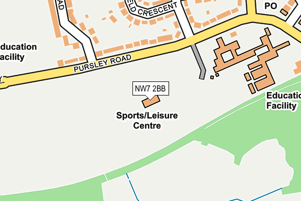
NW7 2BB is located in the Mill Hill electoral ward, within the London borough of Barnet and the English Parliamentary constituency of Hendon. The Sub Integrated Care Board (ICB) Location is NHS North Central London ICB - 93C and the police force is Metropolitan Police. This postcode has been in use since December 1998.


GetTheData
Source: OS OpenMap – Local (Ordnance Survey)
Source: OS VectorMap District (Ordnance Survey)
Licence: Open Government Licence (requires attribution)
| Easting | 522892 |
| Northing | 191345 |
| Latitude | 51.607541 |
| Longitude | -0.226726 |
GetTheData
Source: Open Postcode Geo
Licence: Open Government Licence
| Country | England |
| Postcode District | NW7 |
➜ See where NW7 is on a map ➜ Where is London? | |
GetTheData
Source: Land Registry Price Paid Data
Licence: Open Government Licence
Elevation or altitude of NW7 2BB as distance above sea level:
| Metres | Feet | |
|---|---|---|
| Elevation | 70m | 230ft |
Elevation is measured from the approximate centre of the postcode, to the nearest point on an OS contour line from OS Terrain 50, which has contour spacing of ten vertical metres.
➜ How high above sea level am I? Find the elevation of your current position using your device's GPS.
GetTheData
Source: Open Postcode Elevation
Licence: Open Government Licence
| Ward | Mill Hill |
| Constituency | Hendon |
GetTheData
Source: ONS Postcode Database
Licence: Open Government Licence
| Copthall Sports Centre (Pursley Road) | Mill Hill | 102m |
| Copthall Sports Centre (Pursley Road) | Mill Hill | 102m |
| Salcombe Gardens (Pursley Road) | Mill Hill East | 329m |
| Salcombe Gardens (Pursley Road) | Mill Hill East | 350m |
| Page Street Mill Hill (Pursley Road) | Mill Hill | 375m |
| Mill Hill East Underground Station | Mill Hill East | 1,164m |
| Mill Hill Broadway Station | 1.7km |
| Hendon Station | 3.2km |
| Oakleigh Park Station | 5.4km |
GetTheData
Source: NaPTAN
Licence: Open Government Licence
GetTheData
Source: ONS Postcode Database
Licence: Open Government Licence


➜ Get more ratings from the Food Standards Agency
GetTheData
Source: Food Standards Agency
Licence: FSA terms & conditions
| Last Collection | |||
|---|---|---|---|
| Location | Mon-Fri | Sat | Distance |
| Brookfield Estate Post Office | 17:30 | 12:00 | 323m |
| Wise Lane | 17:30 | 12:00 | 412m |
| Page Street | 17:30 | 12:00 | 426m |
GetTheData
Source: Dracos
Licence: Creative Commons Attribution-ShareAlike
The below table lists the International Territorial Level (ITL) codes (formerly Nomenclature of Territorial Units for Statistics (NUTS) codes) and Local Administrative Units (LAU) codes for NW7 2BB:
| ITL 1 Code | Name |
|---|---|
| TLI | London |
| ITL 2 Code | Name |
| TLI7 | Outer London - West and North West |
| ITL 3 Code | Name |
| TLI71 | Barnet |
| LAU 1 Code | Name |
| E09000003 | Barnet |
GetTheData
Source: ONS Postcode Directory
Licence: Open Government Licence
The below table lists the Census Output Area (OA), Lower Layer Super Output Area (LSOA), and Middle Layer Super Output Area (MSOA) for NW7 2BB:
| Code | Name | |
|---|---|---|
| OA | E00001288 | |
| LSOA | E01000260 | Barnet 025E |
| MSOA | E02000048 | Barnet 025 |
GetTheData
Source: ONS Postcode Directory
Licence: Open Government Licence
| NW7 2BS | Pursley Road | 118m |
| NW7 2BX | Brookfield Avenue | 161m |
| NW7 2BP | Pursley Road | 182m |
| NW7 2DH | Brookfield Crescent | 183m |
| NW7 2BY | Brookfield Avenue | 191m |
| NW7 2BT | Pursley Road | 213m |
| NW7 2DA | Brookfield Close | 224m |
| NW7 2BL | Featherstone Road | 260m |
| NW7 2BN | Featherstone Road | 274m |
| NW7 2DG | Brookfield Crescent | 279m |
GetTheData
Source: Open Postcode Geo; Land Registry Price Paid Data
Licence: Open Government Licence