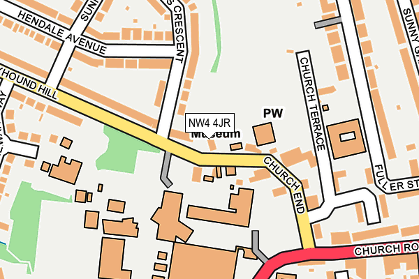
NW4 4JR lies on Greyhound Hill in London. NW4 4JR is located in the Hendon electoral ward, within the London borough of Barnet and the English Parliamentary constituency of Hendon. The Sub Integrated Care Board (ICB) Location is NHS North Central London ICB - 93C and the police force is Metropolitan Police. This postcode has been in use since January 1980.


GetTheData
Source: OS OpenMap – Local (Ordnance Survey)
Source: OS VectorMap District (Ordnance Survey)
Licence: Open Government Licence (requires attribution)
| Easting | 522764 |
| Northing | 189558 |
| Latitude | 51.591509 |
| Longitude | -0.229197 |
GetTheData
Source: Open Postcode Geo
Licence: Open Government Licence
| Street | Greyhound Hill |
| Town/City | London |
| Country | England |
| Postcode District | NW4 |
➜ See where NW4 is on a map ➜ Where is Hendon? | |
GetTheData
Source: Land Registry Price Paid Data
Licence: Open Government Licence
Elevation or altitude of NW4 4JR as distance above sea level:
| Metres | Feet | |
|---|---|---|
| Elevation | 80m | 262ft |
Elevation is measured from the approximate centre of the postcode, to the nearest point on an OS contour line from OS Terrain 50, which has contour spacing of ten vertical metres.
➜ How high above sea level am I? Find the elevation of your current position using your device's GPS.
GetTheData
Source: Open Postcode Elevation
Licence: Open Government Licence
| Ward | Hendon |
| Constituency | Hendon |
GetTheData
Source: ONS Postcode Database
Licence: Open Government Licence
16, GREYHOUND HILL, LONDON, NW4 4JR 2018 6 APR £960,000 |
18, GREYHOUND HILL, LONDON, NW4 4JR 2005 15 SEP £520,000 |
18, GREYHOUND HILL, LONDON, NW4 4JR 2001 29 JUN £365,000 |
GetTheData
Source: HM Land Registry Price Paid Data
Licence: Contains HM Land Registry data © Crown copyright and database right 2025. This data is licensed under the Open Government Licence v3.0.
| Middlesex University | Hendon | 251m |
| Church End (Nw4) | Hendon | 329m |
| Greyhound Hill (Watford Way) | Hendon | 354m |
| Hendon Town Hall | Hendon | 371m |
| Greyhound Hill (Watford Way) | Hendon | 400m |
| Hendon Central Underground Station | Hendon Central | 933m |
| Colindale Underground Station | Colindale | 1,499m |
| Hendon Station | 1.4km |
| Mill Hill Broadway Station | 2.8km |
| Cricklewood Station | 3.9km |
GetTheData
Source: NaPTAN
Licence: Open Government Licence
| Percentage of properties with Next Generation Access | 100.0% |
| Percentage of properties with Superfast Broadband | 100.0% |
| Percentage of properties with Ultrafast Broadband | 100.0% |
| Percentage of properties with Full Fibre Broadband | 0.0% |
Superfast Broadband is between 30Mbps and 300Mbps
Ultrafast Broadband is > 300Mbps
| Percentage of properties unable to receive 2Mbps | 0.0% |
| Percentage of properties unable to receive 5Mbps | 0.0% |
| Percentage of properties unable to receive 10Mbps | 0.0% |
| Percentage of properties unable to receive 30Mbps | 0.0% |
GetTheData
Source: Ofcom
Licence: Ofcom Terms of Use (requires attribution)
GetTheData
Source: ONS Postcode Database
Licence: Open Government Licence


➜ Get more ratings from the Food Standards Agency
GetTheData
Source: Food Standards Agency
Licence: FSA terms & conditions
| Last Collection | |||
|---|---|---|---|
| Location | Mon-Fri | Sat | Distance |
| Hendale Avenue | 17:30 | 12:00 | 104m |
| 9 Church Road | 17:30 | 12:00 | 286m |
| Sunnyfields Road | 17:30 | 12:00 | 355m |
GetTheData
Source: Dracos
Licence: Creative Commons Attribution-ShareAlike
The below table lists the International Territorial Level (ITL) codes (formerly Nomenclature of Territorial Units for Statistics (NUTS) codes) and Local Administrative Units (LAU) codes for NW4 4JR:
| ITL 1 Code | Name |
|---|---|
| TLI | London |
| ITL 2 Code | Name |
| TLI7 | Outer London - West and North West |
| ITL 3 Code | Name |
| TLI71 | Barnet |
| LAU 1 Code | Name |
| E09000003 | Barnet |
GetTheData
Source: ONS Postcode Directory
Licence: Open Government Licence
The below table lists the Census Output Area (OA), Lower Layer Super Output Area (LSOA), and Middle Layer Super Output Area (MSOA) for NW4 4JR:
| Code | Name | |
|---|---|---|
| OA | E00001187 | |
| LSOA | E01000244 | Barnet 032D |
| MSOA | E02000055 | Barnet 032 |
GetTheData
Source: ONS Postcode Directory
Licence: Open Government Licence
| NW4 4JS | Greyhound Hill | 67m |
| NW4 4JP | Greyhound Hill | 122m |
| NW4 4LS | Hendale Avenue | 143m |
| NW4 4JT | Church End | 152m |
| NW4 4LH | St Marys Crescent | 164m |
| NW4 4LP | Hendale Avenue | 170m |
| NW4 4LJ | St Marys Crescent | 173m |
| NW4 4JN | Greyhound Hill | 213m |
| NW4 4JH | Hatchcroft | 216m |
| NW4 4LN | Sunny Hill | 236m |
GetTheData
Source: Open Postcode Geo; Land Registry Price Paid Data
Licence: Open Government Licence