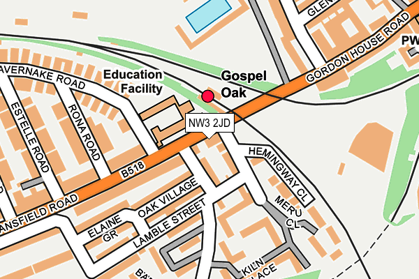
NW3 2JD lies on Mansfield Road in London. NW3 2JD is located in the Gospel Oak electoral ward, within the London borough of Camden and the English Parliamentary constituency of Holborn and St Pancras. The Sub Integrated Care Board (ICB) Location is NHS North Central London ICB - 93C and the police force is Metropolitan Police. This postcode has been in use since January 1980.


GetTheData
Source: OS OpenMap – Local (Ordnance Survey)
Source: OS VectorMap District (Ordnance Survey)
Licence: Open Government Licence (requires attribution)
| Easting | 528263 |
| Northing | 185610 |
| Latitude | 51.554803 |
| Longitude | -0.151325 |
GetTheData
Source: Open Postcode Geo
Licence: Open Government Licence
| Street | Mansfield Road |
| Town/City | London |
| Country | England |
| Postcode District | NW3 |
➜ See where NW3 is on a map ➜ Where is London? | |
GetTheData
Source: Land Registry Price Paid Data
Licence: Open Government Licence
Elevation or altitude of NW3 2JD as distance above sea level:
| Metres | Feet | |
|---|---|---|
| Elevation | 50m | 164ft |
Elevation is measured from the approximate centre of the postcode, to the nearest point on an OS contour line from OS Terrain 50, which has contour spacing of ten vertical metres.
➜ How high above sea level am I? Find the elevation of your current position using your device's GPS.
GetTheData
Source: Open Postcode Elevation
Licence: Open Government Licence
| Ward | Gospel Oak |
| Constituency | Holborn And St Pancras |
GetTheData
Source: ONS Postcode Database
Licence: Open Government Licence
9, MANSFIELD ROAD, LONDON, NW3 2JD 2010 24 NOV £750,000 |
GetTheData
Source: HM Land Registry Price Paid Data
Licence: Contains HM Land Registry data © Crown copyright and database right 2025. This data is licensed under the Open Government Licence v3.0.
| Gospel Oak Station (Mansfield Road) | Gospel Oak | 24m |
| Gospel Oak Station (Mansfield Road) | Gospel Oak | 33m |
| Estelle Road (Mansfield Road) | Gospel Oak | 214m |
| Gordon House Road | Gospel Oak | 234m |
| Estelle Road (Mansfield Road) | Gospel Oak | 265m |
| Kentish Town Underground Station | Kentish Town | 888m |
| Tufnell Park Underground Station | Tufnell Park | 922m |
| Belsize Park Underground Station | Belsize Park | 1,050m |
| Chalk Farm Underground Station | Chalk Farm | 1,197m |
| Archway Underground Station | Archway | 1,649m |
| Gospel Oak Station | 0.1km |
| Kentish Town Station | 0.9km |
| Kentish Town West Station | 1km |
GetTheData
Source: NaPTAN
Licence: Open Government Licence
| Percentage of properties with Next Generation Access | 100.0% |
| Percentage of properties with Superfast Broadband | 100.0% |
| Percentage of properties with Ultrafast Broadband | 50.0% |
| Percentage of properties with Full Fibre Broadband | 0.0% |
Superfast Broadband is between 30Mbps and 300Mbps
Ultrafast Broadband is > 300Mbps
| Median download speed | 60.0Mbps |
| Average download speed | 54.9Mbps |
| Maximum download speed | 100.00Mbps |
| Median upload speed | 9.8Mbps |
| Average upload speed | 10.0Mbps |
| Maximum upload speed | 19.53Mbps |
| Percentage of properties unable to receive 2Mbps | 0.0% |
| Percentage of properties unable to receive 5Mbps | 0.0% |
| Percentage of properties unable to receive 10Mbps | 0.0% |
| Percentage of properties unable to receive 30Mbps | 0.0% |
GetTheData
Source: Ofcom
Licence: Ofcom Terms of Use (requires attribution)
GetTheData
Source: ONS Postcode Database
Licence: Open Government Licence


➜ Get more ratings from the Food Standards Agency
GetTheData
Source: Food Standards Agency
Licence: FSA terms & conditions
| Last Collection | |||
|---|---|---|---|
| Location | Mon-Fri | Sat | Distance |
| Lamble Road | 17:30 | 12:00 | 91m |
| Savernake Road | 17:30 | 12:00 | 235m |
| Mansfield Road Post Office | 18:30 | 12:00 | 238m |
GetTheData
Source: Dracos
Licence: Creative Commons Attribution-ShareAlike
The below table lists the International Territorial Level (ITL) codes (formerly Nomenclature of Territorial Units for Statistics (NUTS) codes) and Local Administrative Units (LAU) codes for NW3 2JD:
| ITL 1 Code | Name |
|---|---|
| TLI | London |
| ITL 2 Code | Name |
| TLI3 | Inner London - West |
| ITL 3 Code | Name |
| TLI31 | Camden and City of London |
| LAU 1 Code | Name |
| E09000007 | Camden |
GetTheData
Source: ONS Postcode Directory
Licence: Open Government Licence
The below table lists the Census Output Area (OA), Lower Layer Super Output Area (LSOA), and Middle Layer Super Output Area (MSOA) for NW3 2JD:
| Code | Name | |
|---|---|---|
| OA | E00004392 | |
| LSOA | E01000886 | Camden 006A |
| MSOA | E02000171 | Camden 006 |
GetTheData
Source: ONS Postcode Directory
Licence: Open Government Licence
| NW5 4QR | Oak Village | 35m |
| NW5 4QP | Oak Village | 45m |
| NW5 4QL | Oak Village | 98m |
| NW5 4QN | Oak Village | 102m |
| NW3 2JB | Mansfield Road | 110m |
| NW5 4AP | Kiln Place | 133m |
| NW3 2JE | Mansfield Road | 139m |
| NW5 4AL | Kiln Place | 140m |
| NW5 4AN | Kiln Place | 152m |
| NW3 2JA | Rona Road | 159m |
GetTheData
Source: Open Postcode Geo; Land Registry Price Paid Data
Licence: Open Government Licence