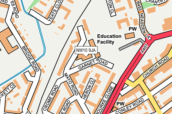
NW10 9JA is located in the Roundwood electoral ward, within the London borough of Brent and the English Parliamentary constituency of Brent Central. The Sub Integrated Care Board (ICB) Location is NHS North West London ICB - W2U3Z and the police force is Metropolitan Police. This postcode has been in use since January 1980.


GetTheData
Source: OS OpenMap – Local (Ordnance Survey)
Source: OS VectorMap District (Ordnance Survey)
Licence: Open Government Licence (requires attribution)
| Easting | 521293 |
| Northing | 184723 |
| Latitude | 51.548371 |
| Longitude | -0.252115 |
GetTheData
Source: Open Postcode Geo
Licence: Open Government Licence
| Country | England |
| Postcode District | NW10 |
➜ See where NW10 is on a map ➜ Where is London? | |
GetTheData
Source: Land Registry Price Paid Data
Licence: Open Government Licence
Elevation or altitude of NW10 9JA as distance above sea level:
| Metres | Feet | |
|---|---|---|
| Elevation | 40m | 131ft |
Elevation is measured from the approximate centre of the postcode, to the nearest point on an OS contour line from OS Terrain 50, which has contour spacing of ten vertical metres.
➜ How high above sea level am I? Find the elevation of your current position using your device's GPS.
GetTheData
Source: Open Postcode Elevation
Licence: Open Government Licence
| Ward | Roundwood |
| Constituency | Brent Central |
GetTheData
Source: ONS Postcode Database
Licence: Open Government Licence
| Mayo Road (Church Road) | Church End | 197m |
| Roundwood Road (Church Road) | Church End | 200m |
| Wharton Close (Neasden Lane) | Church End | 255m |
| Eric Road (Church Road) | Church End | 258m |
| Ilex Road (Church Road) | Church End | 303m |
| Neasden Underground Station | Neasden | 644m |
| Dollis Hill Underground Station | Dudden Hill | 989m |
| Harlesden Underground Station | Harlesden | 1,400m |
| Harlesden Station | 1.4km |
| Stonebridge Park Station | 1.7km |
| Willesden Junction Station | 1.8km |
GetTheData
Source: NaPTAN
Licence: Open Government Licence
GetTheData
Source: ONS Postcode Database
Licence: Open Government Licence


➜ Get more ratings from the Food Standards Agency
GetTheData
Source: Food Standards Agency
Licence: FSA terms & conditions
| Last Collection | |||
|---|---|---|---|
| Location | Mon-Fri | Sat | Distance |
| Church Road Post Office | 18:30 | 12:00 | 301m |
| Church Road | 17:30 | 12:00 | 316m |
| Neasden Lane | 17:30 | 12:00 | 330m |
GetTheData
Source: Dracos
Licence: Creative Commons Attribution-ShareAlike
The below table lists the International Territorial Level (ITL) codes (formerly Nomenclature of Territorial Units for Statistics (NUTS) codes) and Local Administrative Units (LAU) codes for NW10 9JA:
| ITL 1 Code | Name |
|---|---|
| TLI | London |
| ITL 2 Code | Name |
| TLI7 | Outer London - West and North West |
| ITL 3 Code | Name |
| TLI72 | Brent |
| LAU 1 Code | Name |
| E09000005 | Brent |
GetTheData
Source: ONS Postcode Directory
Licence: Open Government Licence
The below table lists the Census Output Area (OA), Lower Layer Super Output Area (LSOA), and Middle Layer Super Output Area (MSOA) for NW10 9JA:
| Code | Name | |
|---|---|---|
| OA | E00002558 | |
| LSOA | E01000526 | Brent 025D |
| MSOA | E02000117 | Brent 025 |
GetTheData
Source: ONS Postcode Directory
Licence: Open Government Licence
| NW10 9HX | Garnet Road | 66m |
| NW10 9HS | Garrard Walk | 71m |
| NW10 9HQ | Mayo Road | 97m |
| NW10 9HP | Mayo Road | 119m |
| NW10 9HT | Heron Close | 124m |
| NW10 9HU | Talbot Walk | 144m |
| NW10 0BW | Yeats Close | 178m |
| NW10 9DG | Bridge Road | 182m |
| NW10 9NH | Church Road | 189m |
| NW10 9EE | Church Road | 190m |
GetTheData
Source: Open Postcode Geo; Land Registry Price Paid Data
Licence: Open Government Licence