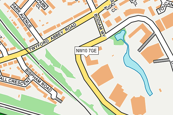
NW10 7GE is located in the Stonebridge electoral ward, within the London borough of Brent and the English Parliamentary constituency of Brent Central. The Sub Integrated Care Board (ICB) Location is NHS North West London ICB - W2U3Z and the police force is Metropolitan Police. This postcode has been in use since May 2016.


GetTheData
Source: OS OpenMap – Local (Ordnance Survey)
Source: OS VectorMap District (Ordnance Survey)
Licence: Open Government Licence (requires attribution)
| Easting | 518954 |
| Northing | 182766 |
| Latitude | 51.531281 |
| Longitude | -0.286492 |
GetTheData
Source: Open Postcode Geo
Licence: Open Government Licence
| Country | England |
| Postcode District | NW10 |
➜ See where NW10 is on a map ➜ Where is London? | |
GetTheData
Source: Land Registry Price Paid Data
Licence: Open Government Licence
Elevation or altitude of NW10 7GE as distance above sea level:
| Metres | Feet | |
|---|---|---|
| Elevation | 30m | 98ft |
Elevation is measured from the approximate centre of the postcode, to the nearest point on an OS contour line from OS Terrain 50, which has contour spacing of ten vertical metres.
➜ How high above sea level am I? Find the elevation of your current position using your device's GPS.
GetTheData
Source: Open Postcode Elevation
Licence: Open Government Licence
| Ward | Stonebridge |
| Constituency | Brent Central |
GetTheData
Source: ONS Postcode Database
Licence: Open Government Licence
| Lakeside Drive (Nw10) | Park Royal | 99m |
| Twyford Abbey Roadpark Avenue | Park Royal | 114m |
| Bodiam Way | Park Royal | 116m |
| Twyford Abbey Roadpark Avenue | Park Royal | 126m |
| Bodiam Way | Park Royal | 137m |
| Hanger Lane Underground Station | Hanger Lane | 448m |
| Park Royal Underground Station | Park Royal | 486m |
| Alperton Underground Station | Alperton | 1,382m |
| West Acton Underground Station | West Acton | 1,526m |
| Stonebridge Park Underground Station | Stonebridge Park | 1,590m |
| Stonebridge Park Station | 1.6km |
| Harlesden Station | 2.1km |
| Acton Main Line Station | 2.1km |
GetTheData
Source: NaPTAN
Licence: Open Government Licence
| Percentage of properties with Next Generation Access | 100.0% |
| Percentage of properties with Superfast Broadband | 100.0% |
| Percentage of properties with Ultrafast Broadband | 100.0% |
| Percentage of properties with Full Fibre Broadband | 100.0% |
Superfast Broadband is between 30Mbps and 300Mbps
Ultrafast Broadband is > 300Mbps
| Median download speed | 55.0Mbps |
| Average download speed | 50.1Mbps |
| Maximum download speed | 74.87Mbps |
| Median upload speed | 10.0Mbps |
| Average upload speed | 9.0Mbps |
| Maximum upload speed | 20.00Mbps |
| Percentage of properties unable to receive 2Mbps | 0.0% |
| Percentage of properties unable to receive 5Mbps | 0.0% |
| Percentage of properties unable to receive 10Mbps | 0.0% |
| Percentage of properties unable to receive 30Mbps | 0.0% |
GetTheData
Source: Ofcom
Licence: Ofcom Terms of Use (requires attribution)
GetTheData
Source: ONS Postcode Database
Licence: Open Government Licence


➜ Get more ratings from the Food Standards Agency
GetTheData
Source: Food Standards Agency
Licence: FSA terms & conditions
| Last Collection | |||
|---|---|---|---|
| Location | Mon-Fri | Sat | Distance |
| Park Avenue | 17:30 | 12:00 | 153m |
| Twyford Abbey Road | 17:30 | 12:00 | 213m |
| Brentmead Place | 17:30 | 12:00 | 358m |
GetTheData
Source: Dracos
Licence: Creative Commons Attribution-ShareAlike
The below table lists the International Territorial Level (ITL) codes (formerly Nomenclature of Territorial Units for Statistics (NUTS) codes) and Local Administrative Units (LAU) codes for NW10 7GE:
| ITL 1 Code | Name |
|---|---|
| TLI | London |
| ITL 2 Code | Name |
| TLI7 | Outer London - West and North West |
| ITL 3 Code | Name |
| TLI72 | Brent |
| LAU 1 Code | Name |
| E09000005 | Brent |
GetTheData
Source: ONS Postcode Directory
Licence: Open Government Licence
The below table lists the Census Output Area (OA), Lower Layer Super Output Area (LSOA), and Middle Layer Super Output Area (MSOA) for NW10 7GE:
| Code | Name | |
|---|---|---|
| OA | E00174692 | |
| LSOA | E01000600 | Brent 027E |
| MSOA | E02000119 | Brent 027 |
GetTheData
Source: ONS Postcode Directory
Licence: Open Government Licence
| NW10 7FF | Agate Close | 139m |
| NW10 7ET | Twyford Abbey Road | 144m |
| NW10 7HB | Bispham Road | 160m |
| NW10 7FE | Agate Close | 171m |
| NW10 7FB | Agate Close | 195m |
| NW10 7DY | Park Close | 205m |
| NW10 7DU | Spencer Close | 212m |
| NW10 7HA | Twyford Abbey Road | 214m |
| NW10 7EU | Park Avenue | 221m |
| NW10 7FR | Lakeside Drive | 227m |
GetTheData
Source: Open Postcode Geo; Land Registry Price Paid Data
Licence: Open Government Licence