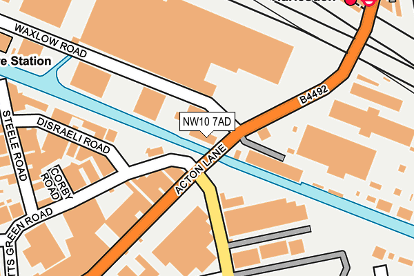
NW10 7AD is located in the Stonebridge electoral ward, within the London borough of Brent and the English Parliamentary constituency of Brent Central. The Sub Integrated Care Board (ICB) Location is NHS North West London ICB - W2U3Z and the police force is Metropolitan Police. This postcode has been in use since January 1980.


GetTheData
Source: OS OpenMap – Local (Ordnance Survey)
Source: OS VectorMap District (Ordnance Survey)
Licence: Open Government Licence (requires attribution)
| Easting | 520742 |
| Northing | 183162 |
| Latitude | 51.534460 |
| Longitude | -0.260592 |
GetTheData
Source: Open Postcode Geo
Licence: Open Government Licence
| Country | England |
| Postcode District | NW10 |
➜ See where NW10 is on a map ➜ Where is London? | |
GetTheData
Source: Land Registry Price Paid Data
Licence: Open Government Licence
Elevation or altitude of NW10 7AD as distance above sea level:
| Metres | Feet | |
|---|---|---|
| Elevation | 40m | 131ft |
Elevation is measured from the approximate centre of the postcode, to the nearest point on an OS contour line from OS Terrain 50, which has contour spacing of ten vertical metres.
➜ How high above sea level am I? Find the elevation of your current position using your device's GPS.
GetTheData
Source: Open Postcode Elevation
Licence: Open Government Licence
| Ward | Stonebridge |
| Constituency | Brent Central |
GetTheData
Source: ONS Postcode Database
Licence: Open Government Licence
| Waxlow Road (Acton Lane) | Old Oak Common | 4m |
| Waxlow Road (Acton Lane) | Old Oak Common | 145m |
| Wesley Avenue North Acton Rd (North Acton Road) | Park Royal | 146m |
| North Acton Road | Old Oak Common | 257m |
| Barretts Green Road (Acton Lane) | Park Royal | 289m |
| Harlesden Underground Station | Harlesden | 279m |
| Willesden Junction Underground Station | Willesden Junction | 1,158m |
| North Acton Underground Station | North Acton | 1,218m |
| Stonebridge Park Underground Station | Stonebridge Park | 1,497m |
| Harlesden Station | 0.3km |
| Willesden Junction Station | 1.1km |
| Stonebridge Park Station | 1.5km |
GetTheData
Source: NaPTAN
Licence: Open Government Licence
GetTheData
Source: ONS Postcode Database
Licence: Open Government Licence


➜ Get more ratings from the Food Standards Agency
GetTheData
Source: Food Standards Agency
Licence: FSA terms & conditions
| Last Collection | |||
|---|---|---|---|
| Location | Mon-Fri | Sat | Distance |
| 91 Barretts Green Road | 17:30 | 12:00 | 40m |
| Acton Lane | 18:30 | 12:00 | 295m |
| Shelly Road | 17:30 | 12:00 | 383m |
GetTheData
Source: Dracos
Licence: Creative Commons Attribution-ShareAlike
The below table lists the International Territorial Level (ITL) codes (formerly Nomenclature of Territorial Units for Statistics (NUTS) codes) and Local Administrative Units (LAU) codes for NW10 7AD:
| ITL 1 Code | Name |
|---|---|
| TLI | London |
| ITL 2 Code | Name |
| TLI7 | Outer London - West and North West |
| ITL 3 Code | Name |
| TLI72 | Brent |
| LAU 1 Code | Name |
| E09000005 | Brent |
GetTheData
Source: ONS Postcode Directory
Licence: Open Government Licence
The below table lists the Census Output Area (OA), Lower Layer Super Output Area (LSOA), and Middle Layer Super Output Area (MSOA) for NW10 7AD:
| Code | Name | |
|---|---|---|
| OA | E00174692 | |
| LSOA | E01000600 | Brent 027E |
| MSOA | E02000119 | Brent 027 |
GetTheData
Source: ONS Postcode Directory
Licence: Open Government Licence
| NW10 7AX | Disraeli Road | 197m |
| NW10 7AE | Barretts Green Road | 203m |
| NW10 7NJ | Acton Lane | 229m |
| NW10 7NH | Acton Lane | 233m |
| NW10 7AS | Steele Road | 270m |
| NW10 7AR | Steele Road | 303m |
| NW10 7BN | Wesley Avenue | 314m |
| NW10 7BL | Wesley Avenue | 321m |
| NW10 7AY | North Acton Road | 330m |
| NW10 8PJ | Greenwood Terrace | 334m |
GetTheData
Source: Open Postcode Geo; Land Registry Price Paid Data
Licence: Open Government Licence