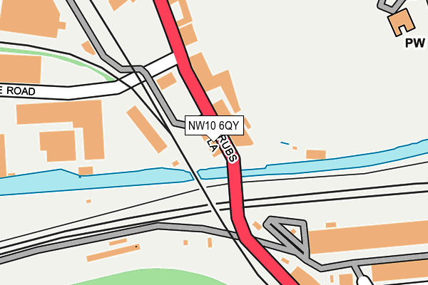
NW10 6QY is located in the College Park & Old Oak electoral ward, within the London borough of Hammersmith and Fulham and the English Parliamentary constituency of Hammersmith. The Sub Integrated Care Board (ICB) Location is NHS North West London ICB - W2U3Z and the police force is Metropolitan Police. This postcode has been in use since January 1980.


GetTheData
Source: OS OpenMap – Local (Ordnance Survey)
Source: OS VectorMap District (Ordnance Survey)
Licence: Open Government Licence (requires attribution)
| Easting | 522461 |
| Northing | 182322 |
| Latitude | 51.526543 |
| Longitude | -0.236089 |
GetTheData
Source: Open Postcode Geo
Licence: Open Government Licence
| Country | England |
| Postcode District | NW10 |
➜ See where NW10 is on a map ➜ Where is London? | |
GetTheData
Source: Land Registry Price Paid Data
Licence: Open Government Licence
Elevation or altitude of NW10 6QY as distance above sea level:
| Metres | Feet | |
|---|---|---|
| Elevation | 30m | 98ft |
Elevation is measured from the approximate centre of the postcode, to the nearest point on an OS contour line from OS Terrain 50, which has contour spacing of ten vertical metres.
➜ How high above sea level am I? Find the elevation of your current position using your device's GPS.
GetTheData
Source: Open Postcode Elevation
Licence: Open Government Licence
| Ward | College Park & Old Oak |
| Constituency | Hammersmith |
GetTheData
Source: ONS Postcode Database
Licence: Open Government Licence
| Hythe Road (Scrubs Lane) | College Park | 97m |
| Hythe Road (Scrubs Lane) | College Park | 172m |
| Mitre Bridge | College Park | 245m |
| Cumberland Business Park (Scrubs Lane) | College Park | 258m |
| Mitre Bridge | College Park | 294m |
| Willesden Junction Underground Station | Willesden Junction | 852m |
| Kensal Green Underground Station | Kensal Green | 889m |
| East Acton Underground Station | East Acton | 1,348m |
| Latimer Road Underground Station | Latimer Road | 1,938m |
| Willesden Junction Station | 0.9km |
| Kensal Green Station | 0.9km |
| Kensal Rise Station | 1.4km |
GetTheData
Source: NaPTAN
Licence: Open Government Licence
GetTheData
Source: ONS Postcode Database
Licence: Open Government Licence

➜ Get more ratings from the Food Standards Agency
GetTheData
Source: Food Standards Agency
Licence: FSA terms & conditions
| Last Collection | |||
|---|---|---|---|
| Location | Mon-Fri | Sat | Distance |
| Hythe Road | 18:30 | 12:00 | 221m |
| Cumberland Park | 18:30 | 12:00 | 369m |
| Letchford Gardens | 17:30 | 12:00 | 639m |
GetTheData
Source: Dracos
Licence: Creative Commons Attribution-ShareAlike
The below table lists the International Territorial Level (ITL) codes (formerly Nomenclature of Territorial Units for Statistics (NUTS) codes) and Local Administrative Units (LAU) codes for NW10 6QY:
| ITL 1 Code | Name |
|---|---|
| TLI | London |
| ITL 2 Code | Name |
| TLI3 | Inner London - West |
| ITL 3 Code | Name |
| TLI33 | Kensington & Chelsea and Hammersmith & Fulham |
| LAU 1 Code | Name |
| E09000013 | Hammersmith and Fulham |
GetTheData
Source: ONS Postcode Directory
Licence: Open Government Licence
The below table lists the Census Output Area (OA), Lower Layer Super Output Area (LSOA), and Middle Layer Super Output Area (MSOA) for NW10 6QY:
| Code | Name | |
|---|---|---|
| OA | E00009369 | |
| LSOA | E01001877 | Hammersmith and Fulham 001D |
| MSOA | E02000372 | Hammersmith and Fulham 001 |
GetTheData
Source: ONS Postcode Directory
Licence: Open Government Licence
| NW10 6QU | Scrubs Lane | 235m |
| NW10 6RE | Cumberland Park | 325m |
| NW10 6RA | Scrubs Lane | 368m |
| NW10 6AU | Waldo Road | 447m |
| NW10 6AT | Waldo Road | 471m |
| NW10 6AX | Waldo Road | 481m |
| NW10 6BD | Trenmar Gardens | 499m |
| NW10 6AS | Letchford Gardens | 501m |
| NW10 6UG | Enterprise Way | 516m |
| NW10 6BX | Kenmont Gardens | 517m |
GetTheData
Source: Open Postcode Geo; Land Registry Price Paid Data
Licence: Open Government Licence