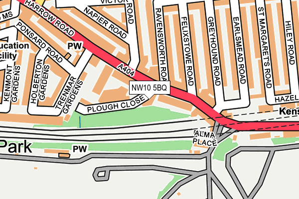
NW10 5BQ is located in the College Park & Old Oak electoral ward, within the London borough of Hammersmith and Fulham and the English Parliamentary constituency of Hammersmith. The Sub Integrated Care Board (ICB) Location is NHS North West London ICB - W2U3Z and the police force is Metropolitan Police. This postcode has been in use since February 2010.


GetTheData
Source: OS OpenMap – Local (Ordnance Survey)
Source: OS VectorMap District (Ordnance Survey)
Licence: Open Government Licence (requires attribution)
| Easting | 522842 |
| Northing | 182794 |
| Latitude | 51.530701 |
| Longitude | -0.230459 |
GetTheData
Source: Open Postcode Geo
Licence: Open Government Licence
| Country | England |
| Postcode District | NW10 |
➜ See where NW10 is on a map ➜ Where is London? | |
GetTheData
Source: Land Registry Price Paid Data
Licence: Open Government Licence
Elevation or altitude of NW10 5BQ as distance above sea level:
| Metres | Feet | |
|---|---|---|
| Elevation | 40m | 131ft |
Elevation is measured from the approximate centre of the postcode, to the nearest point on an OS contour line from OS Terrain 50, which has contour spacing of ten vertical metres.
➜ How high above sea level am I? Find the elevation of your current position using your device's GPS.
GetTheData
Source: Open Postcode Elevation
Licence: Open Government Licence
| Ward | College Park & Old Oak |
| Constituency | Hammersmith |
GetTheData
Source: ONS Postcode Database
Licence: Open Government Licence
| St Mary's Cemetery (Harrow Road) | Kensal Green | 107m |
| Victor Road | Kensal Green | 110m |
| St Mary's Cemetery | Kensal Green | 231m |
| Wrottesley Road Harrow Road (Harrow Road) | Kensal Green | 243m |
| Kensal Green Station (Harrow Road) | Kensal Green | 398m |
| Kensal Green Underground Station | Kensal Green | 378m |
| Willesden Junction Underground Station | Willesden Junction | 975m |
| Ladbroke Grove Underground Station | Ladbroke Grove | 2,028m |
| Kensal Green Station | 0.4km |
| Kensal Rise Station | 0.8km |
| Willesden Junction Station | 1km |
GetTheData
Source: NaPTAN
Licence: Open Government Licence
GetTheData
Source: ONS Postcode Database
Licence: Open Government Licence


➜ Get more ratings from the Food Standards Agency
GetTheData
Source: Food Standards Agency
Licence: FSA terms & conditions
| Last Collection | |||
|---|---|---|---|
| Location | Mon-Fri | Sat | Distance |
| Harrow Road Post Office | 18:30 | 12:00 | 116m |
| College Road | 17:30 | 12:00 | 369m |
| Letchford Gardens | 17:30 | 12:00 | 435m |
GetTheData
Source: Dracos
Licence: Creative Commons Attribution-ShareAlike
The below table lists the International Territorial Level (ITL) codes (formerly Nomenclature of Territorial Units for Statistics (NUTS) codes) and Local Administrative Units (LAU) codes for NW10 5BQ:
| ITL 1 Code | Name |
|---|---|
| TLI | London |
| ITL 2 Code | Name |
| TLI3 | Inner London - West |
| ITL 3 Code | Name |
| TLI33 | Kensington & Chelsea and Hammersmith & Fulham |
| LAU 1 Code | Name |
| E09000013 | Hammersmith and Fulham |
GetTheData
Source: ONS Postcode Directory
Licence: Open Government Licence
The below table lists the Census Output Area (OA), Lower Layer Super Output Area (LSOA), and Middle Layer Super Output Area (MSOA) for NW10 5BQ:
| Code | Name | |
|---|---|---|
| OA | E00009370 | |
| LSOA | E01001877 | Hammersmith and Fulham 001D |
| MSOA | E02000372 | Hammersmith and Fulham 001 |
GetTheData
Source: ONS Postcode Directory
Licence: Open Government Licence
| NW10 5BG | Harrow Road | 51m |
| NW10 5BD | Plough Close | 52m |
| NW10 5NN | Harrow Road | 53m |
| NW10 5NS | Harrow Road | 61m |
| NW10 5NY | Harrow Road | 98m |
| NW10 5NT | Harrow Road | 106m |
| NW10 5NR | Ravensworth Road | 109m |
| NW10 5SR | Felixstowe Road | 119m |
| NW10 5SS | Felixstowe Road | 130m |
| NW10 5NX | Alma Place | 136m |
GetTheData
Source: Open Postcode Geo; Land Registry Price Paid Data
Licence: Open Government Licence