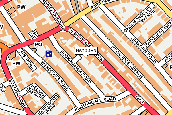
NW10 4RN lies on Buckingham Mews in London. NW10 4RN is located in the Harlesden & Kensal Green electoral ward, within the London borough of Brent and the English Parliamentary constituency of Brent Central. The Sub Integrated Care Board (ICB) Location is NHS North West London ICB - W2U3Z and the police force is Metropolitan Police. This postcode has been in use since October 2002.


GetTheData
Source: OS OpenMap – Local (Ordnance Survey)
Source: OS VectorMap District (Ordnance Survey)
Licence: Open Government Licence (requires attribution)
| Easting | 521873 |
| Northing | 183273 |
| Latitude | 51.535215 |
| Longitude | -0.244256 |
GetTheData
Source: Open Postcode Geo
Licence: Open Government Licence
| Street | Buckingham Mews |
| Town/City | London |
| Country | England |
| Postcode District | NW10 |
➜ See where NW10 is on a map ➜ Where is London? | |
GetTheData
Source: Land Registry Price Paid Data
Licence: Open Government Licence
Elevation or altitude of NW10 4RN as distance above sea level:
| Metres | Feet | |
|---|---|---|
| Elevation | 40m | 131ft |
Elevation is measured from the approximate centre of the postcode, to the nearest point on an OS contour line from OS Terrain 50, which has contour spacing of ten vertical metres.
➜ How high above sea level am I? Find the elevation of your current position using your device's GPS.
GetTheData
Source: Open Postcode Elevation
Licence: Open Government Licence
| Ward | Harlesden & Kensal Green |
| Constituency | Brent Central |
GetTheData
Source: ONS Postcode Database
Licence: Open Government Licence
| Park Parade | Harlesden | 60m |
| Buckingham Road Harlesden | Harlesden | 156m |
| Tubbs Road | Harlesden | 168m |
| Park Parade | Harlesden | 172m |
| Park Parade | Harlesden | 204m |
| Willesden Junction Underground Station | Willesden Junction | 329m |
| Harlesden Underground Station | Harlesden | 953m |
| Kensal Green Underground Station | Kensal Green | 1,433m |
| North Acton Underground Station | North Acton | 1,688m |
| Willesden Junction Station | 0.3km |
| Harlesden Station | 0.9km |
| Kensal Green Station | 1.4km |
GetTheData
Source: NaPTAN
Licence: Open Government Licence
| Percentage of properties with Next Generation Access | 100.0% |
| Percentage of properties with Superfast Broadband | 100.0% |
| Percentage of properties with Ultrafast Broadband | 56.3% |
| Percentage of properties with Full Fibre Broadband | 0.0% |
Superfast Broadband is between 30Mbps and 300Mbps
Ultrafast Broadband is > 300Mbps
| Median download speed | 23.4Mbps |
| Average download speed | 44.1Mbps |
| Maximum download speed | 80.00Mbps |
| Median upload speed | 5.9Mbps |
| Average upload speed | 9.4Mbps |
| Maximum upload speed | 20.00Mbps |
| Percentage of properties unable to receive 2Mbps | 0.0% |
| Percentage of properties unable to receive 5Mbps | 0.0% |
| Percentage of properties unable to receive 10Mbps | 0.0% |
| Percentage of properties unable to receive 30Mbps | 0.0% |
GetTheData
Source: Ofcom
Licence: Ofcom Terms of Use (requires attribution)
Estimated total energy consumption in NW10 4RN by fuel type, 2015.
| Consumption (kWh) | 160,946 |
|---|---|
| Meter count | 16 |
| Mean (kWh/meter) | 10,059 |
| Median (kWh/meter) | 9,876 |
| Consumption (kWh) | 43,056 |
|---|---|
| Meter count | 16 |
| Mean (kWh/meter) | 2,691 |
| Median (kWh/meter) | 1,958 |
GetTheData
Source: Postcode level gas estimates: 2015 (experimental)
Source: Postcode level electricity estimates: 2015 (experimental)
Licence: Open Government Licence
GetTheData
Source: ONS Postcode Database
Licence: Open Government Licence


➜ Get more ratings from the Food Standards Agency
GetTheData
Source: Food Standards Agency
Licence: FSA terms & conditions
| Last Collection | |||
|---|---|---|---|
| Location | Mon-Fri | Sat | Distance |
| 147 High Street | 17:30 | 12:00 | 70m |
| Nw10 Harlesden P.o. | 18:30 | 12:00 | 173m |
| Nw10 Harlesden P.o. | 18:30 | 12:00 | 177m |
GetTheData
Source: Dracos
Licence: Creative Commons Attribution-ShareAlike
The below table lists the International Territorial Level (ITL) codes (formerly Nomenclature of Territorial Units for Statistics (NUTS) codes) and Local Administrative Units (LAU) codes for NW10 4RN:
| ITL 1 Code | Name |
|---|---|
| TLI | London |
| ITL 2 Code | Name |
| TLI7 | Outer London - West and North West |
| ITL 3 Code | Name |
| TLI72 | Brent |
| LAU 1 Code | Name |
| E09000005 | Brent |
GetTheData
Source: ONS Postcode Directory
Licence: Open Government Licence
The below table lists the Census Output Area (OA), Lower Layer Super Output Area (LSOA), and Middle Layer Super Output Area (MSOA) for NW10 4RN:
| Code | Name | |
|---|---|---|
| OA | E00174718 | |
| LSOA | E01033455 | Brent 031G |
| MSOA | E02000123 | Brent 031 |
GetTheData
Source: ONS Postcode Directory
Licence: Open Government Licence
| NW10 4SP | High Street | 26m |
| NW10 4RJ | Buckingham Road | 57m |
| NW10 4TR | High Street | 57m |
| NW10 4RR | Buckingham Road | 66m |
| NW10 4RP | Buckingham Road | 77m |
| NW10 4QA | Rucklidge Avenue | 81m |
| NW10 4TS | High Street | 101m |
| NW10 4SL | High Street | 102m |
| NW10 4ST | High Street | 116m |
| NW10 4RT | Wendover Road | 117m |
GetTheData
Source: Open Postcode Geo; Land Registry Price Paid Data
Licence: Open Government Licence