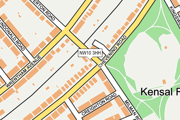
NW10 3HH is located in the Queens Park electoral ward, within the London borough of Brent and the English Parliamentary constituency of Hampstead and Kilburn. The Sub Integrated Care Board (ICB) Location is NHS North West London ICB - W2U3Z and the police force is Metropolitan Police. This postcode has been in use since January 1980.


GetTheData
Source: OS OpenMap – Local (Ordnance Survey)
Source: OS VectorMap District (Ordnance Survey)
Licence: Open Government Licence (requires attribution)
| Easting | 523905 |
| Northing | 183482 |
| Latitude | 51.536654 |
| Longitude | -0.214876 |
GetTheData
Source: Open Postcode Geo
Licence: Open Government Licence
| Country | England |
| Postcode District | NW10 |
➜ See where NW10 is on a map ➜ Where is London? | |
GetTheData
Source: Land Registry Price Paid Data
Licence: Open Government Licence
Elevation or altitude of NW10 3HH as distance above sea level:
| Metres | Feet | |
|---|---|---|
| Elevation | 50m | 164ft |
Elevation is measured from the approximate centre of the postcode, to the nearest point on an OS contour line from OS Terrain 50, which has contour spacing of ten vertical metres.
➜ How high above sea level am I? Find the elevation of your current position using your device's GPS.
GetTheData
Source: Open Postcode Elevation
Licence: Open Government Licence
| Ward | Queens Park |
| Constituency | Hampstead And Kilburn |
GetTheData
Source: ONS Postcode Database
Licence: Open Government Licence
CLOUD HOUSE, 4, TIVERTON ROAD, LONDON, NW10 3HH 2018 31 OCT £1,210,000 |
GetTheData
Source: HM Land Registry Price Paid Data
Licence: Contains HM Land Registry data © Crown copyright and database right 2025. This data is licensed under the Open Government Licence v3.0.
| Wrentham Avenue (Chamberlayne Road) | Kensal Rise | 391m |
| Kensal Rise Station | Kensal Rise | 416m |
| Kensal Rise Station (Chamberlayne Road) | Kensal Rise | 419m |
| Whitmore Gardens (Chamberlayne Road) | Kensal Rise | 423m |
| Whitmore Gardens (Chamberlayne Road) | Kensal Rise | 427m |
| Queen's Park Underground Station | Queen's Park | 768m |
| Kensal Green Underground Station | Kensal Green | 977m |
| Kilburn Underground Station | Brondesbury | 1,355m |
| Kilburn Park Underground Station | Kilburn Park | 1,446m |
| Willesden Green Underground Station | Willesden Green | 1,464m |
| Kensal Rise Station | 0.4km |
| Brondesbury Park Station | 0.6km |
| Queens Park (London) Station | 0.8km |
GetTheData
Source: NaPTAN
Licence: Open Government Licence
| Percentage of properties with Next Generation Access | 100.0% |
| Percentage of properties with Superfast Broadband | 100.0% |
| Percentage of properties with Ultrafast Broadband | 33.3% |
| Percentage of properties with Full Fibre Broadband | 0.0% |
Superfast Broadband is between 30Mbps and 300Mbps
Ultrafast Broadband is > 300Mbps
| Percentage of properties unable to receive 2Mbps | 0.0% |
| Percentage of properties unable to receive 5Mbps | 0.0% |
| Percentage of properties unable to receive 10Mbps | 0.0% |
| Percentage of properties unable to receive 30Mbps | 0.0% |
GetTheData
Source: Ofcom
Licence: Ofcom Terms of Use (requires attribution)
GetTheData
Source: ONS Postcode Database
Licence: Open Government Licence


➜ Get more ratings from the Food Standards Agency
GetTheData
Source: Food Standards Agency
Licence: FSA terms & conditions
| Last Collection | |||
|---|---|---|---|
| Location | Mon-Fri | Sat | Distance |
| Peploe Road | 17:30 | 12:00 | 141m |
| Wrentham Avenue | 17:30 | 12:00 | 160m |
| Aylestone Avenue | 17:30 | 12:00 | 297m |
GetTheData
Source: Dracos
Licence: Creative Commons Attribution-ShareAlike
The below table lists the International Territorial Level (ITL) codes (formerly Nomenclature of Territorial Units for Statistics (NUTS) codes) and Local Administrative Units (LAU) codes for NW10 3HH:
| ITL 1 Code | Name |
|---|---|
| TLI | London |
| ITL 2 Code | Name |
| TLI7 | Outer London - West and North West |
| ITL 3 Code | Name |
| TLI72 | Brent |
| LAU 1 Code | Name |
| E09000005 | Brent |
GetTheData
Source: ONS Postcode Directory
Licence: Open Government Licence
The below table lists the Census Output Area (OA), Lower Layer Super Output Area (LSOA), and Middle Layer Super Output Area (MSOA) for NW10 3HH:
| Code | Name | |
|---|---|---|
| OA | E00002838 | |
| LSOA | E01000582 | Brent 032C |
| MSOA | E02000124 | Brent 032 |
GetTheData
Source: ONS Postcode Directory
Licence: Open Government Licence
| NW6 6DF | St Laurence Close | 49m |
| NW6 6DY | Chevening Road | 81m |
| NW6 6DA | Chevening Road | 91m |
| NW6 6EA | Chevening Road | 123m |
| NW10 3HG | Wrentham Avenue | 124m |
| NW6 6DU | Chevening Road | 135m |
| NW10 3HF | Wrentham Avenue | 141m |
| NW6 6EG | Milman Road | 144m |
| NW6 6ED | Creighton Road | 147m |
| NW10 3HN | Wrentham Avenue | 159m |
GetTheData
Source: Open Postcode Geo; Land Registry Price Paid Data
Licence: Open Government Licence