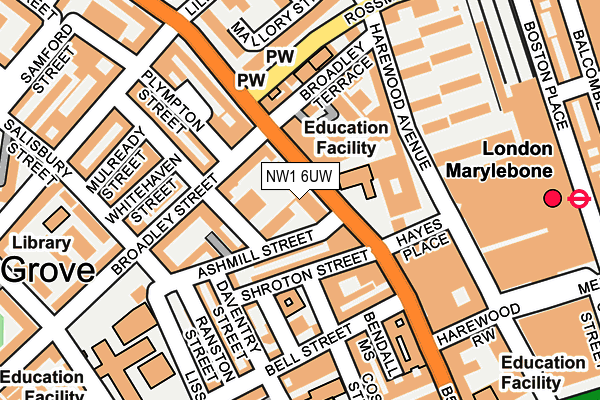
NW1 6UW is located in the Church Street electoral ward, within the London borough of Westminster and the English Parliamentary constituency of Westminster North. The Sub Integrated Care Board (ICB) Location is NHS North West London ICB - W2U3Z and the police force is Metropolitan Police. This postcode has been in use since September 2008.


GetTheData
Source: OS OpenMap – Local (Ordnance Survey)
Source: OS VectorMap District (Ordnance Survey)
Licence: Open Government Licence (requires attribution)
| Easting | 527290 |
| Northing | 182061 |
| Latitude | 51.523129 |
| Longitude | -0.166634 |
GetTheData
Source: Open Postcode Geo
Licence: Open Government Licence
| Country | England |
| Postcode District | NW1 |
➜ See where NW1 is on a map ➜ Where is City of Westminster? | |
GetTheData
Source: Land Registry Price Paid Data
Licence: Open Government Licence
Elevation or altitude of NW1 6UW as distance above sea level:
| Metres | Feet | |
|---|---|---|
| Elevation | 30m | 98ft |
Elevation is measured from the approximate centre of the postcode, to the nearest point on an OS contour line from OS Terrain 50, which has contour spacing of ten vertical metres.
➜ How high above sea level am I? Find the elevation of your current position using your device's GPS.
GetTheData
Source: Open Postcode Elevation
Licence: Open Government Licence
| Ward | Church Street |
| Constituency | Westminster North |
GetTheData
Source: ONS Postcode Database
Licence: Open Government Licence
| Rossmore Road Lisson Grove (Rossmore Road) | Lisson Grove | 136m |
| Rossmore Road Lisson Grove | Lisson Grove | 169m |
| Church Street Market Lisson Grove (Lisson Grove) | Lisson Grove | 259m |
| Church Street Market Lisson Grove (Lisson Grove) | Lisson Grove | 271m |
| Marylebone Station (Marylebone Station Forecourt) | Marylebone | 284m |
| Marylebone Underground Station | Marylebone | 254m |
| Edgware Road (Circle Line) Underground Station | Edgware Road | 373m |
| Edgware Road (Bakerloo) Underground Station | Edgware Road | 398m |
| Baker Street Underground Station | Baker Street | 660m |
| Paddington Underground Station | Paddington | 962m |
| London Marylebone Station | 0.3km |
| London Paddington Station | 1km |
| South Hampstead Station | 2.2km |
GetTheData
Source: NaPTAN
Licence: Open Government Licence
GetTheData
Source: ONS Postcode Database
Licence: Open Government Licence


➜ Get more ratings from the Food Standards Agency
GetTheData
Source: Food Standards Agency
Licence: FSA terms & conditions
| Last Collection | |||
|---|---|---|---|
| Location | Mon-Fri | Sat | Distance |
| Post Office | 19:00 | 13:00 | 121m |
| 37 Lisson Grove | 19:00 | 13:00 | 121m |
| Broadley Terrace | 19:00 | 13:00 | 171m |
GetTheData
Source: Dracos
Licence: Creative Commons Attribution-ShareAlike
The below table lists the International Territorial Level (ITL) codes (formerly Nomenclature of Territorial Units for Statistics (NUTS) codes) and Local Administrative Units (LAU) codes for NW1 6UW:
| ITL 1 Code | Name |
|---|---|
| TLI | London |
| ITL 2 Code | Name |
| TLI3 | Inner London - West |
| ITL 3 Code | Name |
| TLI32 | Westminster |
| LAU 1 Code | Name |
| E09000033 | Westminster |
GetTheData
Source: ONS Postcode Directory
Licence: Open Government Licence
The below table lists the Census Output Area (OA), Lower Layer Super Output Area (LSOA), and Middle Layer Super Output Area (MSOA) for NW1 6UW:
| Code | Name | |
|---|---|---|
| OA | E00023570 | |
| LSOA | E01033603 | Westminster 009I |
| MSOA | E02000968 | Westminster 009 |
GetTheData
Source: ONS Postcode Directory
Licence: Open Government Licence
| NW1 6UN | Lisson Grove | 37m |
| NW8 8AF | Ashbridge Street | 49m |
| NW1 6LF | Lisson Grove | 52m |
| NW1 6LP | Lisson Grove | 52m |
| NW1 6LR | Lisson Grove | 52m |
| NW1 6LS | Lisson Grove | 52m |
| NW1 6LW | Lisson Grove | 52m |
| NW1 6RA | Ashmill Street | 53m |
| NW1 6UT | Lisson Grove | 54m |
| NW1 6UH | Lisson Grove | 60m |
GetTheData
Source: Open Postcode Geo; Land Registry Price Paid Data
Licence: Open Government Licence