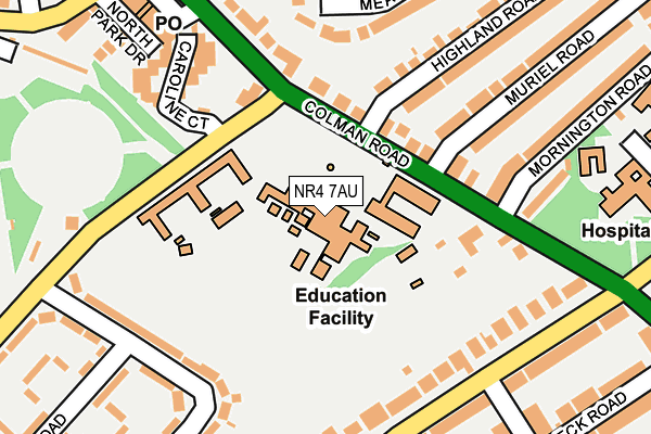
NR4 7AU lies on South Park Avenue in Norwich. NR4 7AU is located in the Eaton electoral ward, within the local authority district of Norwich and the English Parliamentary constituency of Norwich South. The Sub Integrated Care Board (ICB) Location is NHS Norfolk and Waveney ICB - 26A and the police force is Norfolk. This postcode has been in use since January 1980.


GetTheData
Source: OS OpenMap – Local (Ordnance Survey)
Source: OS VectorMap District (Ordnance Survey)
Licence: Open Government Licence (requires attribution)
| Easting | 620950 |
| Northing | 307518 |
| Latitude | 52.620468 |
| Longitude | 1.262742 |
GetTheData
Source: Open Postcode Geo
Licence: Open Government Licence
| Street | South Park Avenue |
| Town/City | Norwich |
| Country | England |
| Postcode District | NR4 |
➜ See where NR4 is on a map ➜ Where is Norwich? | |
GetTheData
Source: Land Registry Price Paid Data
Licence: Open Government Licence
Elevation or altitude of NR4 7AU as distance above sea level:
| Metres | Feet | |
|---|---|---|
| Elevation | 30m | 98ft |
Elevation is measured from the approximate centre of the postcode, to the nearest point on an OS contour line from OS Terrain 50, which has contour spacing of ten vertical metres.
➜ How high above sea level am I? Find the elevation of your current position using your device's GPS.
GetTheData
Source: Open Postcode Elevation
Licence: Open Government Licence
| Ward | Eaton |
| Constituency | Norwich South |
GetTheData
Source: ONS Postcode Database
Licence: Open Government Licence
THE BUNGALOW, SOUTH PARK AVENUE, NORWICH, NR4 7AU 2000 18 DEC £112,950 |
GetTheData
Source: HM Land Registry Price Paid Data
Licence: Contains HM Land Registry data © Crown copyright and database right 2025. This data is licensed under the Open Government Licence v3.0.
| Middle School (South Park Avenue) | Eaton Park | 31m |
| Middle School (South Park Avenue) | Eaton Park | 49m |
| South Park Avenue (Colman Road) | Norwich | 159m |
| South Park Avenue | Eaton Park | 177m |
| South Park Avenue | Eaton Park | 186m |
| Norwich Station | 3.1km |
GetTheData
Source: NaPTAN
Licence: Open Government Licence
GetTheData
Source: ONS Postcode Database
Licence: Open Government Licence


➜ Get more ratings from the Food Standards Agency
GetTheData
Source: Food Standards Agency
Licence: FSA terms & conditions
| Last Collection | |||
|---|---|---|---|
| Location | Mon-Fri | Sat | Distance |
| South Park Ave / Colman Road | 17:35 | 11:00 | 126m |
| Colman Road Spso Box | 17:00 | 12:45 | 142m |
| Leopold Road Post Office | 17:15 | 11:00 | 418m |
GetTheData
Source: Dracos
Licence: Creative Commons Attribution-ShareAlike
The below table lists the International Territorial Level (ITL) codes (formerly Nomenclature of Territorial Units for Statistics (NUTS) codes) and Local Administrative Units (LAU) codes for NR4 7AU:
| ITL 1 Code | Name |
|---|---|
| TLH | East |
| ITL 2 Code | Name |
| TLH1 | East Anglia |
| ITL 3 Code | Name |
| TLH15 | Norwich and East Norfolk |
| LAU 1 Code | Name |
| E07000148 | Norwich |
GetTheData
Source: ONS Postcode Directory
Licence: Open Government Licence
The below table lists the Census Output Area (OA), Lower Layer Super Output Area (LSOA), and Middle Layer Super Output Area (MSOA) for NR4 7AU:
| Code | Name | |
|---|---|---|
| OA | E00136354 | |
| LSOA | E01026814 | Norwich 012E |
| MSOA | E02005595 | Norwich 012 |
GetTheData
Source: ONS Postcode Directory
Licence: Open Government Licence
| NR4 7EJ | Caroline Court | 125m |
| NR4 7EB | North Park Drive | 150m |
| NR4 7AL | Colman Road | 158m |
| NR4 7AN | Colman Road | 171m |
| NR4 7AQ | Colman Road | 207m |
| NR4 7EE | North Park Avenue | 217m |
| NR2 3QQ | Meadow Rise Close | 241m |
| NR4 7AG | Colman Road | 258m |
| NR2 3NW | Highland Road | 259m |
| NR2 3QF | Meadow Rise Road | 275m |
GetTheData
Source: Open Postcode Geo; Land Registry Price Paid Data
Licence: Open Government Licence