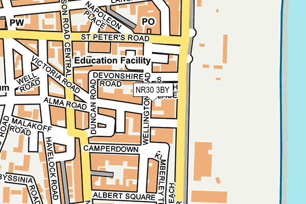
NR30 3BY is located in the Nelson electoral ward, within the local authority district of Great Yarmouth and the English Parliamentary constituency of Great Yarmouth. The Sub Integrated Care Board (ICB) Location is NHS Norfolk and Waveney ICB - 26A and the police force is Norfolk. This postcode has been in use since July 2016.


GetTheData
Source: OS OpenMap – Local (Ordnance Survey)
Source: OS VectorMap District (Ordnance Survey)
Licence: Open Government Licence (requires attribution)
| Easting | 653035 |
| Northing | 306942 |
| Latitude | 52.601315 |
| Longitude | 1.735277 |
GetTheData
Source: Open Postcode Geo
Licence: Open Government Licence
| Country | England |
| Postcode District | NR30 |
➜ See where NR30 is on a map ➜ Where is Great Yarmouth? | |
GetTheData
Source: Land Registry Price Paid Data
Licence: Open Government Licence
Elevation or altitude of NR30 3BY as distance above sea level:
| Metres | Feet | |
|---|---|---|
| Elevation | 0m | 0ft |
Elevation is measured from the approximate centre of the postcode, to the nearest point on an OS contour line from OS Terrain 50, which has contour spacing of ten vertical metres.
➜ How high above sea level am I? Find the elevation of your current position using your device's GPS.
GetTheData
Source: Open Postcode Elevation
Licence: Open Government Licence
| Ward | Nelson |
| Constituency | Great Yarmouth |
GetTheData
Source: ONS Postcode Database
Licence: Open Government Licence
| St Peters Road (Marine Parade) | Great Yarmouth | 125m |
| Wellington Pier (Marine Parade) | Great Yarmouth | 150m |
| Wellington Pier (Marine Parade) | Great Yarmouth | 153m |
| St Peters Road (Marine Parade) | Great Yarmouth | 175m |
| Malakoff Road (Blackfriars Road) | Great Yarmouth | 285m |
| Great Yarmouth Station | 1.6km |
GetTheData
Source: NaPTAN
Licence: Open Government Licence
| Percentage of properties with Next Generation Access | 100.0% |
| Percentage of properties with Superfast Broadband | 100.0% |
| Percentage of properties with Ultrafast Broadband | 0.0% |
| Percentage of properties with Full Fibre Broadband | 0.0% |
Superfast Broadband is between 30Mbps and 300Mbps
Ultrafast Broadband is > 300Mbps
| Percentage of properties unable to receive 2Mbps | 0.0% |
| Percentage of properties unable to receive 5Mbps | 0.0% |
| Percentage of properties unable to receive 10Mbps | 0.0% |
| Percentage of properties unable to receive 30Mbps | 0.0% |
GetTheData
Source: Ofcom
Licence: Ofcom Terms of Use (requires attribution)
GetTheData
Source: ONS Postcode Database
Licence: Open Government Licence


➜ Get more ratings from the Food Standards Agency
GetTheData
Source: Food Standards Agency
Licence: FSA terms & conditions
| Last Collection | |||
|---|---|---|---|
| Location | Mon-Fri | Sat | Distance |
| King Street South | 17:15 | 11:30 | 381m |
| St. Georges Road | 17:45 | 11:30 | 413m |
| Blackfriars Road | 18:30 | 12:00 | 420m |
GetTheData
Source: Dracos
Licence: Creative Commons Attribution-ShareAlike
The below table lists the International Territorial Level (ITL) codes (formerly Nomenclature of Territorial Units for Statistics (NUTS) codes) and Local Administrative Units (LAU) codes for NR30 3BY:
| ITL 1 Code | Name |
|---|---|
| TLH | East |
| ITL 2 Code | Name |
| TLH1 | East Anglia |
| ITL 3 Code | Name |
| TLH15 | Norwich and East Norfolk |
| LAU 1 Code | Name |
| E07000145 | Great Yarmouth |
GetTheData
Source: ONS Postcode Directory
Licence: Open Government Licence
The below table lists the Census Output Area (OA), Lower Layer Super Output Area (LSOA), and Middle Layer Super Output Area (MSOA) for NR30 3BY:
| Code | Name | |
|---|---|---|
| OA | E00169829 | |
| LSOA | E01026626 | Great Yarmouth 006E |
| MSOA | E02005543 | Great Yarmouth 006 |
GetTheData
Source: ONS Postcode Directory
Licence: Open Government Licence
| NR30 3AQ | Wellington Road | 34m |
| NR30 3AH | Marine Parade | 39m |
| NR30 3AF | Waterloo Road | 47m |
| NR30 3AT | Victoria Gardens | 69m |
| NR30 3AG | Marine Parade | 70m |
| NR30 3AW | Wellington Road | 75m |
| NR30 3AN | Marine Passage | 75m |
| NR30 3BH | Victoria Road | 78m |
| NR30 3BN | Melrose Terrace | 86m |
| NR30 3AL | Devonshire Road | 88m |
GetTheData
Source: Open Postcode Geo; Land Registry Price Paid Data
Licence: Open Government Licence