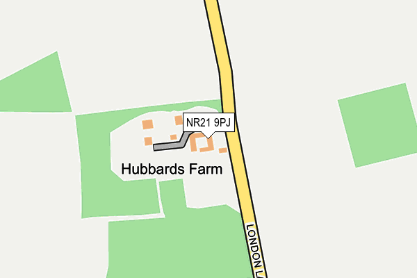
NR21 9PJ is in South Creake, Fakenham. NR21 9PJ is located in the Bircham with Rudhams electoral ward, within the local authority district of King's Lynn and West Norfolk and the English Parliamentary constituency of North West Norfolk. The Sub Integrated Care Board (ICB) Location is NHS Norfolk and Waveney ICB - 26A and the police force is Norfolk. This postcode has been in use since January 1980.


GetTheData
Source: OS OpenMap – Local (Ordnance Survey)
Source: OS VectorMap District (Ordnance Survey)
Licence: Open Government Licence (requires attribution)
| Easting | 586048 |
| Northing | 334659 |
| Latitude | 52.877243 |
| Longitude | 0.763213 |
GetTheData
Source: Open Postcode Geo
Licence: Open Government Licence
| Locality | South Creake |
| Town/City | Fakenham |
| Country | England |
| Postcode District | NR21 |
➜ See where NR21 is on a map | |
GetTheData
Source: Land Registry Price Paid Data
Licence: Open Government Licence
Elevation or altitude of NR21 9PJ as distance above sea level:
| Metres | Feet | |
|---|---|---|
| Elevation | 50m | 164ft |
Elevation is measured from the approximate centre of the postcode, to the nearest point on an OS contour line from OS Terrain 50, which has contour spacing of ten vertical metres.
➜ How high above sea level am I? Find the elevation of your current position using your device's GPS.
GetTheData
Source: Open Postcode Elevation
Licence: Open Government Licence
| Ward | Bircham With Rudhams |
| Constituency | North West Norfolk |
GetTheData
Source: ONS Postcode Database
Licence: Open Government Licence
| Bus Shelter (Front Street) | South Creake | 969m |
| Bridge School (Front Street) | South Creake | 1,398m |
GetTheData
Source: NaPTAN
Licence: Open Government Licence
GetTheData
Source: ONS Postcode Database
Licence: Open Government Licence


➜ Get more ratings from the Food Standards Agency
GetTheData
Source: Food Standards Agency
Licence: FSA terms & conditions
| Last Collection | |||
|---|---|---|---|
| Location | Mon-Fri | Sat | Distance |
| Quarles | 15:30 | 08:15 | 4,608m |
| Shammer Cross Roads | 16:00 | 10:45 | 4,741m |
| The Street | 16:45 | 08:00 | 5,228m |
GetTheData
Source: Dracos
Licence: Creative Commons Attribution-ShareAlike
The below table lists the International Territorial Level (ITL) codes (formerly Nomenclature of Territorial Units for Statistics (NUTS) codes) and Local Administrative Units (LAU) codes for NR21 9PJ:
| ITL 1 Code | Name |
|---|---|
| TLH | East |
| ITL 2 Code | Name |
| TLH1 | East Anglia |
| ITL 3 Code | Name |
| TLH16 | North and West Norfolk |
| LAU 1 Code | Name |
| E07000146 | King's Lynn and West Norfolk |
GetTheData
Source: ONS Postcode Directory
Licence: Open Government Licence
The below table lists the Census Output Area (OA), Lower Layer Super Output Area (LSOA), and Middle Layer Super Output Area (MSOA) for NR21 9PJ:
| Code | Name | |
|---|---|---|
| OA | E00135678 | |
| LSOA | E01026695 | King's Lynn and West Norfolk 002D |
| MSOA | E02005552 | King's Lynn and West Norfolk 002 |
GetTheData
Source: ONS Postcode Directory
Licence: Open Government Licence
| NR21 9NZ | Leicester Meadows | 616m |
| NR21 9PW | Leicester Road | 618m |
| NR21 9PN | Churchill Estate | 673m |
| NR21 9NY | Leicester Meadows | 677m |
| NR21 9PA | Southgate | 721m |
| NR21 9PS | Winston Drive | 743m |
| NR21 9PL | Churchill Estate | 805m |
| NR21 9PH | Avondale Road | 827m |
| NR21 9PP | Back Lane | 839m |
| NR21 9PR | Fakenham Road | 883m |
GetTheData
Source: Open Postcode Geo; Land Registry Price Paid Data
Licence: Open Government Licence