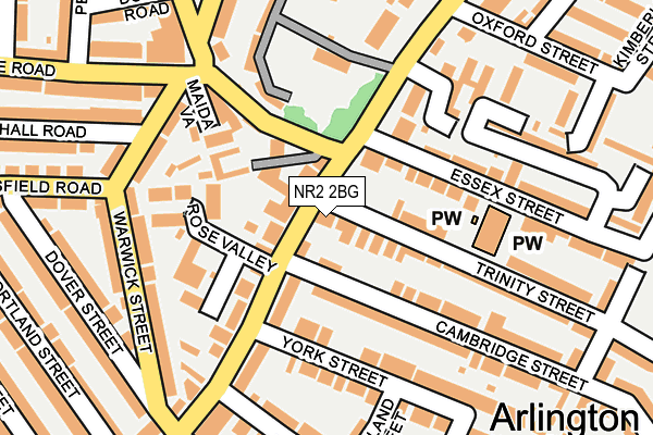
NR2 2BG is located in the Town Close electoral ward, within the local authority district of Norwich and the English Parliamentary constituency of Norwich South. The Sub Integrated Care Board (ICB) Location is NHS Norfolk and Waveney ICB - 26A and the police force is Norfolk. This postcode has been in use since January 1980.


GetTheData
Source: OS OpenMap – Local (Ordnance Survey)
Source: OS VectorMap District (Ordnance Survey)
Licence: Open Government Licence (requires attribution)
| Easting | 621988 |
| Northing | 308064 |
| Latitude | 52.624921 |
| Longitude | 1.278394 |
GetTheData
Source: Open Postcode Geo
Licence: Open Government Licence
| Country | England |
| Postcode District | NR2 |
➜ See where NR2 is on a map ➜ Where is Norwich? | |
GetTheData
Source: Land Registry Price Paid Data
Licence: Open Government Licence
Elevation or altitude of NR2 2BG as distance above sea level:
| Metres | Feet | |
|---|---|---|
| Elevation | 20m | 66ft |
Elevation is measured from the approximate centre of the postcode, to the nearest point on an OS contour line from OS Terrain 50, which has contour spacing of ten vertical metres.
➜ How high above sea level am I? Find the elevation of your current position using your device's GPS.
GetTheData
Source: Open Postcode Elevation
Licence: Open Government Licence
| Ward | Town Close |
| Constituency | Norwich South |
GetTheData
Source: ONS Postcode Database
Licence: Open Government Licence
| Gloucester Street (Unthank Road) | Norwich | 142m |
| Somerleyton Street (Unthank Road) | Norwich | 145m |
| Somerleyton Road (Unthank Road) | Norwich | 193m |
| Gloucester Street (Unthank Road) | Norwich | 230m |
| Pembroke Road (Avenue Road) | Norwich | 259m |
| Norwich Station | 1.9km |
GetTheData
Source: NaPTAN
Licence: Open Government Licence
GetTheData
Source: ONS Postcode Database
Licence: Open Government Licence


➜ Get more ratings from the Food Standards Agency
GetTheData
Source: Food Standards Agency
Licence: FSA terms & conditions
| Last Collection | |||
|---|---|---|---|
| Location | Mon-Fri | Sat | Distance |
| 93 Unthank Road | 17:30 | 11:00 | 29m |
| Unthank Road Post Office | 17:30 | 11:00 | 283m |
| Vauxhall Street Post Office | 17:30 | 12:00 | 311m |
GetTheData
Source: Dracos
Licence: Creative Commons Attribution-ShareAlike
The below table lists the International Territorial Level (ITL) codes (formerly Nomenclature of Territorial Units for Statistics (NUTS) codes) and Local Administrative Units (LAU) codes for NR2 2BG:
| ITL 1 Code | Name |
|---|---|
| TLH | East |
| ITL 2 Code | Name |
| TLH1 | East Anglia |
| ITL 3 Code | Name |
| TLH15 | Norwich and East Norfolk |
| LAU 1 Code | Name |
| E07000148 | Norwich |
GetTheData
Source: ONS Postcode Directory
Licence: Open Government Licence
The below table lists the Census Output Area (OA), Lower Layer Super Output Area (LSOA), and Middle Layer Super Output Area (MSOA) for NR2 2BG:
| Code | Name | |
|---|---|---|
| OA | E00136602 | |
| LSOA | E01026856 | Norwich 011E |
| MSOA | E02005594 | Norwich 011 |
GetTheData
Source: ONS Postcode Directory
Licence: Open Government Licence
| NR2 2RR | Unthank Road | 75m |
| NR2 2PE | Unthank Road | 105m |
| NR2 2BJ | Trinity Street | 106m |
| NR2 2RW | Unthank Road | 109m |
| NR2 3EL | Park Lane | 110m |
| NR2 2BB | Cambridge Street | 129m |
| NR2 2PX | Rose Valley | 131m |
| NR2 2PU | Primrose Place | 132m |
| NR2 3EP | Maida Vale | 135m |
| NR2 2BQ | Trinity Street | 138m |
GetTheData
Source: Open Postcode Geo; Land Registry Price Paid Data
Licence: Open Government Licence