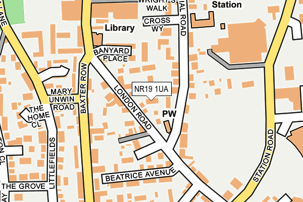
NR19 1UA lies on London Road in Dereham. NR19 1UA is located in the Dereham Neatherd electoral ward, within the local authority district of Breckland and the English Parliamentary constituency of Mid Norfolk. The Sub Integrated Care Board (ICB) Location is NHS Norfolk and Waveney ICB - 26A and the police force is Norfolk. This postcode has been in use since April 1987.


GetTheData
Source: OS OpenMap – Local (Ordnance Survey)
Source: OS VectorMap District (Ordnance Survey)
Licence: Open Government Licence (requires attribution)
| Easting | 599051 |
| Northing | 312936 |
| Latitude | 52.677548 |
| Longitude | 0.942956 |
GetTheData
Source: Open Postcode Geo
Licence: Open Government Licence
| Street | London Road |
| Town/City | Dereham |
| Country | England |
| Postcode District | NR19 |
➜ See where NR19 is on a map ➜ Where is Dereham? | |
GetTheData
Source: Land Registry Price Paid Data
Licence: Open Government Licence
Elevation or altitude of NR19 1UA as distance above sea level:
| Metres | Feet | |
|---|---|---|
| Elevation | 50m | 164ft |
Elevation is measured from the approximate centre of the postcode, to the nearest point on an OS contour line from OS Terrain 50, which has contour spacing of ten vertical metres.
➜ How high above sea level am I? Find the elevation of your current position using your device's GPS.
GetTheData
Source: Open Postcode Elevation
Licence: Open Government Licence
| Ward | Dereham Neatherd |
| Constituency | Mid Norfolk |
GetTheData
Source: ONS Postcode Database
Licence: Open Government Licence
| Swan Road (London Road) | Dereham | 125m |
| London Road | Dereham | 129m |
| Morrisons (Station Road) | Dereham | 228m |
| Morrisons (Station Road) | Dereham | 236m |
| Moorgate Cottages (Southend) | Dereham | 265m |
| Dereham (Mid Norfolk Railway) | Dereham | 338m |
GetTheData
Source: NaPTAN
Licence: Open Government Licence
| Percentage of properties with Next Generation Access | 100.0% |
| Percentage of properties with Superfast Broadband | 100.0% |
| Percentage of properties with Ultrafast Broadband | 0.0% |
| Percentage of properties with Full Fibre Broadband | 0.0% |
Superfast Broadband is between 30Mbps and 300Mbps
Ultrafast Broadband is > 300Mbps
| Percentage of properties unable to receive 2Mbps | 0.0% |
| Percentage of properties unable to receive 5Mbps | 0.0% |
| Percentage of properties unable to receive 10Mbps | 0.0% |
| Percentage of properties unable to receive 30Mbps | 0.0% |
GetTheData
Source: Ofcom
Licence: Ofcom Terms of Use (requires attribution)
Estimated total energy consumption in NR19 1UA by fuel type, 2015.
| Consumption (kWh) | 44,656 |
|---|---|
| Meter count | 8 |
| Mean (kWh/meter) | 5,582 |
| Median (kWh/meter) | 4,653 |
| Consumption (kWh) | 12,555 |
|---|---|
| Meter count | 7 |
| Mean (kWh/meter) | 1,794 |
| Median (kWh/meter) | 2,219 |
GetTheData
Source: Postcode level gas estimates: 2015 (experimental)
Source: Postcode level electricity estimates: 2015 (experimental)
Licence: Open Government Licence
GetTheData
Source: ONS Postcode Database
Licence: Open Government Licence


➜ Get more ratings from the Food Standards Agency
GetTheData
Source: Food Standards Agency
Licence: FSA terms & conditions
| Last Collection | |||
|---|---|---|---|
| Location | Mon-Fri | Sat | Distance |
| Morrisons Station Road | 17:30 | 09:00 | 272m |
| Church Street | 17:30 | 12:30 | 416m |
| Royal Mail Quebec Road | 18:00 | 571m | |
GetTheData
Source: Dracos
Licence: Creative Commons Attribution-ShareAlike
The below table lists the International Territorial Level (ITL) codes (formerly Nomenclature of Territorial Units for Statistics (NUTS) codes) and Local Administrative Units (LAU) codes for NR19 1UA:
| ITL 1 Code | Name |
|---|---|
| TLH | East |
| ITL 2 Code | Name |
| TLH1 | East Anglia |
| ITL 3 Code | Name |
| TLH17 | Breckland and South Norfolk |
| LAU 1 Code | Name |
| E07000143 | Breckland |
GetTheData
Source: ONS Postcode Directory
Licence: Open Government Licence
The below table lists the Census Output Area (OA), Lower Layer Super Output Area (LSOA), and Middle Layer Super Output Area (MSOA) for NR19 1UA:
| Code | Name | |
|---|---|---|
| OA | E00134268 | |
| LSOA | E01026426 | Breckland 005B |
| MSOA | E02005507 | Breckland 005 |
GetTheData
Source: ONS Postcode Directory
Licence: Open Government Licence
| NR19 1TJ | The Dodmans | 45m |
| NR19 1AR | Mayes Terrace | 59m |
| NR19 1AS | London Road | 66m |
| NR19 1AP | Prospect Place | 78m |
| NR19 1AN | Churchill Court | 117m |
| NR19 1AE | Commercial Road | 118m |
| NR19 1AT | Banyard Place | 126m |
| NR19 1EF | Howard Crescent | 130m |
| NR19 1AL | Foundry Square | 131m |
| NR19 1AF | London Road | 154m |
GetTheData
Source: Open Postcode Geo; Land Registry Price Paid Data
Licence: Open Government Licence