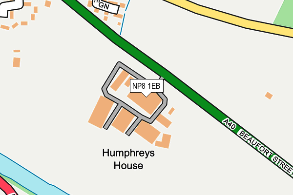
NP8 1EB is located in the Crickhowell with Cwmdu and Tretower electoral ward, within the unitary authority of Powys and the Welsh Parliamentary constituency of Brecon and Radnorshire. The Local Health Board is Powys Teaching and the police force is Dyfed-Powys. This postcode has been in use since January 1980.


GetTheData
Source: OS OpenMap – Local (Ordnance Survey)
Source: OS VectorMap District (Ordnance Survey)
Licence: Open Government Licence (requires attribution)
| Easting | 322253 |
| Northing | 217894 |
| Latitude | 51.854200 |
| Longitude | -3.130229 |
GetTheData
Source: Open Postcode Geo
Licence: Open Government Licence
| Country | Wales |
| Postcode District | NP8 |
➜ See where NP8 is on a map | |
GetTheData
Source: Land Registry Price Paid Data
Licence: Open Government Licence
Elevation or altitude of NP8 1EB as distance above sea level:
| Metres | Feet | |
|---|---|---|
| Elevation | 190m | 623ft |
Elevation is measured from the approximate centre of the postcode, to the nearest point on an OS contour line from OS Terrain 50, which has contour spacing of ten vertical metres.
➜ How high above sea level am I? Find the elevation of your current position using your device's GPS.
GetTheData
Source: Open Postcode Elevation
Licence: Open Government Licence
| Ward | Crickhowell With Cwmdu And Tretower |
| Constituency | Brecon And Radnorshire |
GetTheData
Source: ONS Postcode Database
Licence: Open Government Licence
| Elvicta Estate (A40) | Crickhowell | 57m |
| Elvicta Estate (A40) | Crickhowell | 67m |
| Maesyffynnon (Unclassified) | Crickhowell | 392m |
| Square (Beaufort Street) | Crickhowell | 676m |
| Square (Beaufort Street) | Crickhowell | 682m |
GetTheData
Source: NaPTAN
Licence: Open Government Licence
GetTheData
Source: ONS Postcode Database
Licence: Open Government Licence


➜ Get more ratings from the Food Standards Agency
GetTheData
Source: Food Standards Agency
Licence: FSA terms & conditions
| Last Collection | |||
|---|---|---|---|
| Location | Mon-Fri | Sat | Distance |
| Llangenny Lane | 17:00 | 11:00 | 319m |
| Crickhowell Post Office | 17:30 | 11:30 | 579m |
| The Fountain High Street | 17:00 | 11:00 | 693m |
GetTheData
Source: Dracos
Licence: Creative Commons Attribution-ShareAlike
The below table lists the International Territorial Level (ITL) codes (formerly Nomenclature of Territorial Units for Statistics (NUTS) codes) and Local Administrative Units (LAU) codes for NP8 1EB:
| ITL 1 Code | Name |
|---|---|
| TLL | Wales |
| ITL 2 Code | Name |
| TLL2 | East Wales |
| ITL 3 Code | Name |
| TLL24 | Powys |
| LAU 1 Code | Name |
| W06000023 | Powys |
GetTheData
Source: ONS Postcode Directory
Licence: Open Government Licence
The below table lists the Census Output Area (OA), Lower Layer Super Output Area (LSOA), and Middle Layer Super Output Area (MSOA) for NP8 1EB:
| Code | Name | |
|---|---|---|
| OA | W00009790 | |
| LSOA | W01001904 | Powys 018G |
| MSOA | W02000114 | Powys 018 |
GetTheData
Source: ONS Postcode Directory
Licence: Open Government Licence
| NP8 1DF | Elvicta Estates | 51m |
| NP8 1AN | Llangenny Lane | 268m |
| NP8 1HN | 330m | |
| NP8 1AL | Greenhill Villas | 380m |
| NP8 1AP | Castle Road | 412m |
| NP8 1AG | Beaufort Street | 430m |
| NP8 1SN | Bellfountain Road | 445m |
| NP8 1AQ | Cwrt Newydd | 483m |
| NP8 1AF | Greenhill Way | 516m |
| NP8 1BN | Clarence Villas | 609m |
GetTheData
Source: Open Postcode Geo; Land Registry Price Paid Data
Licence: Open Government Licence