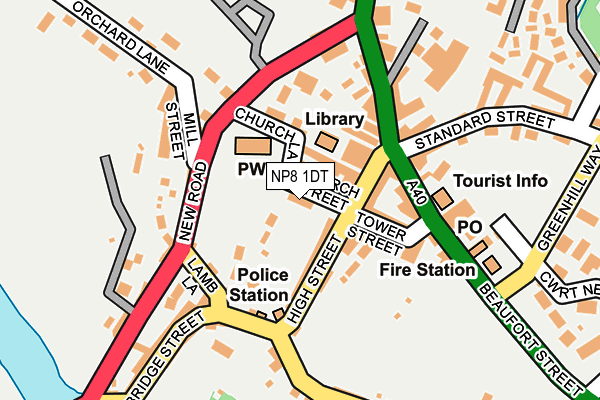
NP8 1DT lies on Latham Court in Crickhowell. NP8 1DT is located in the Crickhowell with Cwmdu and Tretower electoral ward, within the unitary authority of Powys and the Welsh Parliamentary constituency of Brecon and Radnorshire. The Local Health Board is Powys Teaching and the police force is Dyfed-Powys. This postcode has been in use since January 1980.


GetTheData
Source: OS OpenMap – Local (Ordnance Survey)
Source: OS VectorMap District (Ordnance Survey)
Licence: Open Government Licence (requires attribution)
| Easting | 321698 |
| Northing | 218380 |
| Latitude | 51.858491 |
| Longitude | -3.138396 |
GetTheData
Source: Open Postcode Geo
Licence: Open Government Licence
| Street | Latham Court |
| Town/City | Crickhowell |
| Country | Wales |
| Postcode District | NP8 |
➜ See where NP8 is on a map ➜ Where is Crickhowell? | |
GetTheData
Source: Land Registry Price Paid Data
Licence: Open Government Licence
Elevation or altitude of NP8 1DT as distance above sea level:
| Metres | Feet | |
|---|---|---|
| Elevation | 200m | 656ft |
Elevation is measured from the approximate centre of the postcode, to the nearest point on an OS contour line from OS Terrain 50, which has contour spacing of ten vertical metres.
➜ How high above sea level am I? Find the elevation of your current position using your device's GPS.
GetTheData
Source: Open Postcode Elevation
Licence: Open Government Licence
| Ward | Crickhowell With Cwmdu And Tretower |
| Constituency | Brecon And Radnorshire |
GetTheData
Source: ONS Postcode Database
Licence: Open Government Licence
| Square (Beaufort Street) | Crickhowell | 105m |
| Square (Beaufort Street) | Crickhowell | 116m |
| High School (Grounds) | Crickhowell | 185m |
| Maesyffynnon (Unclassified) | Crickhowell | 364m |
| Primary School (Oakfield Drive) | Crickhowell | 645m |
GetTheData
Source: NaPTAN
Licence: Open Government Licence
| Median download speed | 24.1Mbps |
| Average download speed | 37.9Mbps |
| Maximum download speed | 80.00Mbps |
| Median upload speed | 1.3Mbps |
| Average upload speed | 6.7Mbps |
| Maximum upload speed | 20.00Mbps |
GetTheData
Source: Ofcom
Licence: Ofcom Terms of Use (requires attribution)
Estimated total energy consumption in NP8 1DT by fuel type, 2015.
| Consumption (kWh) | 54,073 |
|---|---|
| Meter count | 7 |
| Mean (kWh/meter) | 7,725 |
| Median (kWh/meter) | 7,582 |
GetTheData
Source: Postcode level gas estimates: 2015 (experimental)
Source: Postcode level electricity estimates: 2015 (experimental)
Licence: Open Government Licence
GetTheData
Source: ONS Postcode Database
Licence: Open Government Licence


➜ Get more ratings from the Food Standards Agency
GetTheData
Source: Food Standards Agency
Licence: FSA terms & conditions
| Last Collection | |||
|---|---|---|---|
| Location | Mon-Fri | Sat | Distance |
| The Fountain High Street | 17:00 | 11:00 | 47m |
| Crickhowell Post Office | 17:30 | 11:30 | 177m |
| Bridge Street | 16:45 | 11:00 | 223m |
GetTheData
Source: Dracos
Licence: Creative Commons Attribution-ShareAlike
The below table lists the International Territorial Level (ITL) codes (formerly Nomenclature of Territorial Units for Statistics (NUTS) codes) and Local Administrative Units (LAU) codes for NP8 1DT:
| ITL 1 Code | Name |
|---|---|
| TLL | Wales |
| ITL 2 Code | Name |
| TLL2 | East Wales |
| ITL 3 Code | Name |
| TLL24 | Powys |
| LAU 1 Code | Name |
| W06000023 | Powys |
GetTheData
Source: ONS Postcode Directory
Licence: Open Government Licence
The below table lists the Census Output Area (OA), Lower Layer Super Output Area (LSOA), and Middle Layer Super Output Area (MSOA) for NP8 1DT:
| Code | Name | |
|---|---|---|
| OA | W00002320 | |
| LSOA | W01001903 | Powys 018F |
| MSOA | W02000114 | Powys 018 |
GetTheData
Source: ONS Postcode Directory
Licence: Open Government Licence
| NP8 1BB | Church Lane | 30m |
| NP8 1BJ | Silver Lane | 50m |
| NP8 1BE | High Street | 68m |
| NP8 1BH | High Street | 78m |
| NP8 1BD | High Street | 84m |
| NP8 1BL | Tower Street | 90m |
| NP8 1BG | Orchard Court | 104m |
| NP8 1AU | New Road | 114m |
| NP8 1AD | Beaufort Street | 119m |
| NP8 1BQ | Tower Street | 120m |
GetTheData
Source: Open Postcode Geo; Land Registry Price Paid Data
Licence: Open Government Licence