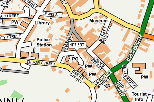
NP7 5RT lies on St Johns Street in Abergavenny. NP7 5RT is located in the Grofield electoral ward, within the unitary authority of Monmouthshire and the Welsh Parliamentary constituency of Monmouth. The Local Health Board is Aneurin Bevan University and the police force is Gwent. This postcode has been in use since January 1980.


GetTheData
Source: OS OpenMap – Local (Ordnance Survey)
Source: OS VectorMap District (Ordnance Survey)
Licence: Open Government Licence (requires attribution)
| Easting | 329860 |
| Northing | 214192 |
| Latitude | 51.821935 |
| Longitude | -3.019056 |
GetTheData
Source: Open Postcode Geo
Licence: Open Government Licence
| Street | St Johns Street |
| Town/City | Abergavenny |
| Country | Wales |
| Postcode District | NP7 |
➜ See where NP7 is on a map ➜ Where is Abergavenny? | |
GetTheData
Source: Land Registry Price Paid Data
Licence: Open Government Licence
Elevation or altitude of NP7 5RT as distance above sea level:
| Metres | Feet | |
|---|---|---|
| Elevation | 60m | 197ft |
Elevation is measured from the approximate centre of the postcode, to the nearest point on an OS contour line from OS Terrain 50, which has contour spacing of ten vertical metres.
➜ How high above sea level am I? Find the elevation of your current position using your device's GPS.
GetTheData
Source: Open Postcode Elevation
Licence: Open Government Licence
| Ward | Grofield |
| Constituency | Monmouth |
GetTheData
Source: ONS Postcode Database
Licence: Open Government Licence
| Lion Street Car Park (Lion Street) | Abergavenny | 158m |
| Pavilion (Monk Street) | Abergavenny | 233m |
| Pavilion (Monk Street) | Abergavenny | 253m |
| Richards Shop (Frogmore Street) | Abergavenny | 309m |
| Tesco (Park Road) | Abergavenny | 365m |
| Abergavenny Station | 0.9km |
GetTheData
Source: NaPTAN
Licence: Open Government Licence
| Percentage of properties with Next Generation Access | 100.0% |
| Percentage of properties with Superfast Broadband | 100.0% |
| Percentage of properties with Ultrafast Broadband | 100.0% |
| Percentage of properties with Full Fibre Broadband | 100.0% |
Superfast Broadband is between 30Mbps and 300Mbps
Ultrafast Broadband is > 300Mbps
| Percentage of properties unable to receive 2Mbps | 0.0% |
| Percentage of properties unable to receive 5Mbps | 0.0% |
| Percentage of properties unable to receive 10Mbps | 0.0% |
| Percentage of properties unable to receive 30Mbps | 0.0% |
GetTheData
Source: Ofcom
Licence: Ofcom Terms of Use (requires attribution)
GetTheData
Source: ONS Postcode Database
Licence: Open Government Licence


➜ Get more ratings from the Food Standards Agency
GetTheData
Source: Food Standards Agency
Licence: FSA terms & conditions
| Last Collection | |||
|---|---|---|---|
| Location | Mon-Fri | Sat | Distance |
| Cross Street | 17:15 | 11:15 | 219m |
| Frogmore Street Post Office | 17:00 | 11:00 | 324m |
| Pant Y Goitre | 16:15 | 10:00 | 424m |
GetTheData
Source: Dracos
Licence: Creative Commons Attribution-ShareAlike
The below table lists the International Territorial Level (ITL) codes (formerly Nomenclature of Territorial Units for Statistics (NUTS) codes) and Local Administrative Units (LAU) codes for NP7 5RT:
| ITL 1 Code | Name |
|---|---|
| TLL | Wales |
| ITL 2 Code | Name |
| TLL2 | East Wales |
| ITL 3 Code | Name |
| TLL21 | Monmouthshire and Newport |
| LAU 1 Code | Name |
| W06000021 | Monmouthshire |
GetTheData
Source: ONS Postcode Directory
Licence: Open Government Licence
The below table lists the Census Output Area (OA), Lower Layer Super Output Area (LSOA), and Middle Layer Super Output Area (MSOA) for NP7 5RT:
| Code | Name | |
|---|---|---|
| OA | W00008119 | |
| LSOA | W01001557 | Monmouthshire 001C |
| MSOA | W02000336 | Monmouthshire 001 |
GetTheData
Source: ONS Postcode Directory
Licence: Open Government Licence
| NP7 5AD | Nevill Street | 46m |
| NP7 5AA | Nevill Street | 61m |
| NP7 5RY | High Street | 75m |
| NP7 5EH | Cross Street | 82m |
| NP7 5SD | Market Street | 96m |
| NP7 5EU | Cross Street | 114m |
| NP7 5AU | Frogmore Street | 129m |
| NP7 5EE | Castle Street | 153m |
| NP7 5NH | Magnolia Terrace | 170m |
| NP7 5BB | Baker Street | 186m |
GetTheData
Source: Open Postcode Geo; Land Registry Price Paid Data
Licence: Open Government Licence