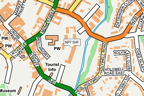
NP7 5HF lies on Monmouth Road in Abergavenny. NP7 5HF is located in the Grofield electoral ward, within the unitary authority of Monmouthshire and the Welsh Parliamentary constituency of Monmouth. The Local Health Board is Aneurin Bevan University and the police force is Gwent. This postcode has been in use since January 1980.


GetTheData
Source: OS OpenMap – Local (Ordnance Survey)
Source: OS VectorMap District (Ordnance Survey)
Licence: Open Government Licence (requires attribution)
| Easting | 330177 |
| Northing | 214051 |
| Latitude | 51.820707 |
| Longitude | -3.014429 |
GetTheData
Source: Open Postcode Geo
Licence: Open Government Licence
| Street | Monmouth Road |
| Town/City | Abergavenny |
| Country | Wales |
| Postcode District | NP7 |
➜ See where NP7 is on a map ➜ Where is Abergavenny? | |
GetTheData
Source: Land Registry Price Paid Data
Licence: Open Government Licence
Elevation or altitude of NP7 5HF as distance above sea level:
| Metres | Feet | |
|---|---|---|
| Elevation | 50m | 164ft |
Elevation is measured from the approximate centre of the postcode, to the nearest point on an OS contour line from OS Terrain 50, which has contour spacing of ten vertical metres.
➜ How high above sea level am I? Find the elevation of your current position using your device's GPS.
GetTheData
Source: Open Postcode Elevation
Licence: Open Government Licence
| Ward | Grofield |
| Constituency | Monmouth |
GetTheData
Source: ONS Postcode Database
Licence: Open Government Licence
21, MONMOUTH ROAD, ABERGAVENNY, NP7 5HF 2005 3 OCT £420,000 |
21, MONMOUTH ROAD, ABERGAVENNY, NP7 5HF 2002 10 JUN £244,817 |
GetTheData
Source: HM Land Registry Price Paid Data
Licence: Contains HM Land Registry data © Crown copyright and database right 2025. This data is licensed under the Open Government Licence v3.0.
| Pavilion (Monk Street) | Abergavenny | 181m |
| Pavilion (Monk Street) | Abergavenny | 218m |
| Hollywell Crescent | Abergavenny | 241m |
| Hollywell Crescent | Abergavenny | 293m |
| Belmont Crescent | Abergavenny | 377m |
| Abergavenny Station | 0.6km |
GetTheData
Source: NaPTAN
Licence: Open Government Licence
| Percentage of properties with Next Generation Access | 100.0% |
| Percentage of properties with Superfast Broadband | 100.0% |
| Percentage of properties with Ultrafast Broadband | 0.0% |
| Percentage of properties with Full Fibre Broadband | 0.0% |
Superfast Broadband is between 30Mbps and 300Mbps
Ultrafast Broadband is > 300Mbps
| Median download speed | 21.0Mbps |
| Average download speed | 35.5Mbps |
| Maximum download speed | 80.00Mbps |
| Median upload speed | 1.2Mbps |
| Average upload speed | 6.7Mbps |
| Maximum upload speed | 20.00Mbps |
| Percentage of properties unable to receive 2Mbps | 0.0% |
| Percentage of properties unable to receive 5Mbps | 0.0% |
| Percentage of properties unable to receive 10Mbps | 0.0% |
| Percentage of properties unable to receive 30Mbps | 0.0% |
GetTheData
Source: Ofcom
Licence: Ofcom Terms of Use (requires attribution)
GetTheData
Source: ONS Postcode Database
Licence: Open Government Licence


➜ Get more ratings from the Food Standards Agency
GetTheData
Source: Food Standards Agency
Licence: FSA terms & conditions
| Last Collection | |||
|---|---|---|---|
| Location | Mon-Fri | Sat | Distance |
| Cross Street | 17:15 | 11:15 | 155m |
| Frogmore Street Post Office | 17:00 | 11:00 | 630m |
| Pant Y Goitre | 16:15 | 10:00 | 710m |
GetTheData
Source: Dracos
Licence: Creative Commons Attribution-ShareAlike
The below table lists the International Territorial Level (ITL) codes (formerly Nomenclature of Territorial Units for Statistics (NUTS) codes) and Local Administrative Units (LAU) codes for NP7 5HF:
| ITL 1 Code | Name |
|---|---|
| TLL | Wales |
| ITL 2 Code | Name |
| TLL2 | East Wales |
| ITL 3 Code | Name |
| TLL21 | Monmouthshire and Newport |
| LAU 1 Code | Name |
| W06000021 | Monmouthshire |
GetTheData
Source: ONS Postcode Directory
Licence: Open Government Licence
The below table lists the Census Output Area (OA), Lower Layer Super Output Area (LSOA), and Middle Layer Super Output Area (MSOA) for NP7 5HF:
| Code | Name | |
|---|---|---|
| OA | W00008223 | |
| LSOA | W01001579 | Monmouthshire 001E |
| MSOA | W02000336 | Monmouthshire 001 |
GetTheData
Source: ONS Postcode Directory
Licence: Open Government Licence
| NP7 5NQ | Priory Gardens | 104m |
| NP7 5NE | Beili Priory | 113m |
| NP7 5LR | Holywell Road | 121m |
| NP7 5ER | Cross Street | 144m |
| NP7 5NJ | Monk Street | 159m |
| NP7 5ND | Monk Street | 160m |
| NP7 5EW | Cross Street | 162m |
| NP7 5LU | Lower Monk Street | 163m |
| NP7 5NP | Monk Street | 176m |
| NP7 5EX | Mill Street | 178m |
GetTheData
Source: Open Postcode Geo; Land Registry Price Paid Data
Licence: Open Government Licence