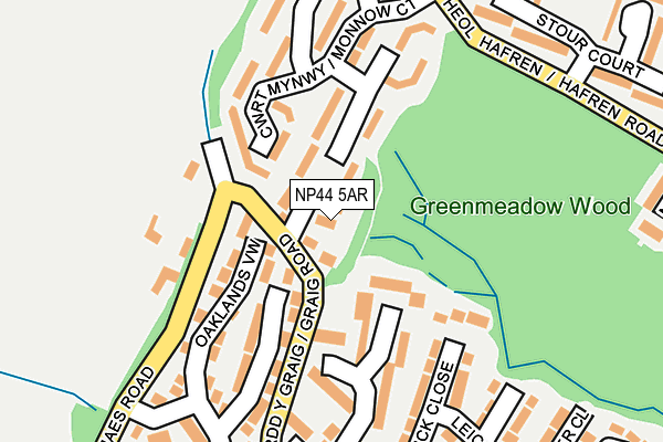
NP44 5AR is in Greenmeadow, Cwmbran. NP44 5AR is located in the Greenmeadow electoral ward, within the unitary authority of Torfaen and the Welsh Parliamentary constituency of Torfaen. The Local Health Board is Aneurin Bevan University and the police force is Gwent. This postcode has been in use since January 1980.


GetTheData
Source: OS OpenMap – Local (Ordnance Survey)
Source: OS VectorMap District (Ordnance Survey)
Licence: Open Government Licence (requires attribution)
| Easting | 327167 |
| Northing | 195600 |
| Latitude | 51.654451 |
| Longitude | -3.054217 |
GetTheData
Source: Open Postcode Geo
Licence: Open Government Licence
| Locality | Greenmeadow |
| Town/City | Cwmbran |
| Country | Wales |
| Postcode District | NP44 |
➜ See where NP44 is on a map ➜ Where is Cwmbrân? | |
GetTheData
Source: Land Registry Price Paid Data
Licence: Open Government Licence
Elevation or altitude of NP44 5AR as distance above sea level:
| Metres | Feet | |
|---|---|---|
| Elevation | 200m | 656ft |
Elevation is measured from the approximate centre of the postcode, to the nearest point on an OS contour line from OS Terrain 50, which has contour spacing of ten vertical metres.
➜ How high above sea level am I? Find the elevation of your current position using your device's GPS.
GetTheData
Source: Open Postcode Elevation
Licence: Open Government Licence
| Ward | Greenmeadow |
| Constituency | Torfaen |
GetTheData
Source: ONS Postcode Database
Licence: Open Government Licence
CHANNEL VIEW HOUSE, GREENMEADOW, CWMBRAN, NP44 5AR 2018 7 NOV £366,250 |
SANJIKA, GREENMEADOW, CWMBRAN, NP44 5AR 2014 11 JUN £315,000 |
HOLLY HOUSE, GREENMEADOW, CWMBRAN, NP44 5AR 2007 17 AUG £333,000 |
HOLLY HOUSE, GREENMEADOW, CWMBRAN, NP44 5AR 2003 7 NOV £260,000 |
SANJIKA, GREENMEADOW, CWMBRAN, NP44 5AR 2001 30 APR £180,000 |
AYERA, GREENMEADOW, CWMBRAN, NP44 5AR 2000 29 SEP £165,000 |
CHANNEL VIEW HOUSE, GREENMEADOW, CWMBRAN, NP44 5AR 1999 17 DEC £95,000 |
GetTheData
Source: HM Land Registry Price Paid Data
Licence: Contains HM Land Registry data © Crown copyright and database right 2025. This data is licensed under the Open Government Licence v3.0.
| Monnow Court (Hafren Court) | Thornhill | 216m |
| Stour Court (Hafren Road) | Thornhill | 241m |
| Trannon Court (Hafren Road) | Thornhill | 346m |
| Barnets (Ty Gwyn Road) | Greenmeadow | 440m |
| Kingfisher (Hafren Road) | Thornhill | 444m |
| Cwmbran Station | 2.6km |
| Pontypool & New Inn Station | 5.6km |
GetTheData
Source: NaPTAN
Licence: Open Government Licence
| Percentage of properties with Next Generation Access | 100.0% |
| Percentage of properties with Superfast Broadband | 100.0% |
| Percentage of properties with Ultrafast Broadband | 0.0% |
| Percentage of properties with Full Fibre Broadband | 0.0% |
Superfast Broadband is between 30Mbps and 300Mbps
Ultrafast Broadband is > 300Mbps
| Percentage of properties unable to receive 2Mbps | 0.0% |
| Percentage of properties unable to receive 5Mbps | 0.0% |
| Percentage of properties unable to receive 10Mbps | 0.0% |
| Percentage of properties unable to receive 30Mbps | 0.0% |
GetTheData
Source: Ofcom
Licence: Ofcom Terms of Use (requires attribution)
GetTheData
Source: ONS Postcode Database
Licence: Open Government Licence


➜ Get more ratings from the Food Standards Agency
GetTheData
Source: Food Standards Agency
Licence: FSA terms & conditions
| Last Collection | |||
|---|---|---|---|
| Location | Mon-Fri | Sat | Distance |
| Five Locks Close | 17:30 | 11:00 | 1,888m |
| Radnor Way | 17:30 | 11:00 | 2,283m |
| Llantarnam Road | 17:30 | 11:00 | 2,938m |
GetTheData
Source: Dracos
Licence: Creative Commons Attribution-ShareAlike
The below table lists the International Territorial Level (ITL) codes (formerly Nomenclature of Territorial Units for Statistics (NUTS) codes) and Local Administrative Units (LAU) codes for NP44 5AR:
| ITL 1 Code | Name |
|---|---|
| TLL | Wales |
| ITL 2 Code | Name |
| TLL1 | West Wales and The Valleys |
| ITL 3 Code | Name |
| TLL16 | Gwent Valleys |
| LAU 1 Code | Name |
| W06000020 | Torfaen |
GetTheData
Source: ONS Postcode Directory
Licence: Open Government Licence
The below table lists the Census Output Area (OA), Lower Layer Super Output Area (LSOA), and Middle Layer Super Output Area (MSOA) for NP44 5AR:
| Code | Name | |
|---|---|---|
| OA | W00007842 | |
| LSOA | W01001502 | Torfaen 011E |
| MSOA | W02000333 | Torfaen 011 |
GetTheData
Source: ONS Postcode Directory
Licence: Open Government Licence
| NP44 5SB | Monnow Court | 77m |
| NP44 5SD | Monnow Court | 117m |
| NP44 5ED | Oaklands View | 121m |
| NP44 5EJ | Marlborough Road | 155m |
| NP44 5SA | Monnow Court | 169m |
| NP44 5EE | Oaklands View | 171m |
| NP44 5HG | Warwick Close | 187m |
| NP44 5SF | Monnow Court | 213m |
| NP44 5SE | Monnow Court | 231m |
| NP44 5UE | Stour Court | 242m |
GetTheData
Source: Open Postcode Geo; Land Registry Price Paid Data
Licence: Open Government Licence