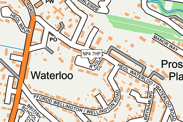
NP4 7HP lies on Raglan Close in Talywain, Pontypool. NP4 7HP is located in the Abersychan electoral ward, within the unitary authority of Torfaen and the Welsh Parliamentary constituency of Torfaen. The Local Health Board is Aneurin Bevan University and the police force is Gwent. This postcode has been in use since March 1982.


GetTheData
Source: OS OpenMap – Local (Ordnance Survey)
Source: OS VectorMap District (Ordnance Survey)
Licence: Open Government Licence (requires attribution)
| Easting | 326369 |
| Northing | 203858 |
| Latitude | 51.728583 |
| Longitude | -3.067496 |
GetTheData
Source: Open Postcode Geo
Licence: Open Government Licence
| Street | Raglan Close |
| Locality | Talywain |
| Town/City | Pontypool |
| Country | Wales |
| Postcode District | NP4 |
➜ See where NP4 is on a map ➜ Where is Abersychan? | |
GetTheData
Source: Land Registry Price Paid Data
Licence: Open Government Licence
Elevation or altitude of NP4 7HP as distance above sea level:
| Metres | Feet | |
|---|---|---|
| Elevation | 250m | 820ft |
Elevation is measured from the approximate centre of the postcode, to the nearest point on an OS contour line from OS Terrain 50, which has contour spacing of ten vertical metres.
➜ How high above sea level am I? Find the elevation of your current position using your device's GPS.
GetTheData
Source: Open Postcode Elevation
Licence: Open Government Licence
| Ward | Abersychan |
| Constituency | Torfaen |
GetTheData
Source: ONS Postcode Database
Licence: Open Government Licence
| Raglan Close (Waterloo Road) | Talywain | 26m |
| Raglan Close (Waterloo Road) | Abersychan | 40m |
| Coronation Terrace (Wellington Road) | Abersychan | 83m |
| Gordon Road (Wellington Road) | Abersychan | 159m |
| Gordon Road (Wellington Road) | Abersychan | 166m |
| Pontypool & New Inn Station | 5km |
| Llanhilleth Station | 5.6km |
GetTheData
Source: NaPTAN
Licence: Open Government Licence
| Percentage of properties with Next Generation Access | 100.0% |
| Percentage of properties with Superfast Broadband | 100.0% |
| Percentage of properties with Ultrafast Broadband | 0.0% |
| Percentage of properties with Full Fibre Broadband | 0.0% |
Superfast Broadband is between 30Mbps and 300Mbps
Ultrafast Broadband is > 300Mbps
| Median download speed | 38.8Mbps |
| Average download speed | 29.9Mbps |
| Maximum download speed | 55.00Mbps |
| Median upload speed | 3.0Mbps |
| Average upload speed | 3.1Mbps |
| Maximum upload speed | 6.91Mbps |
| Percentage of properties unable to receive 2Mbps | 0.0% |
| Percentage of properties unable to receive 5Mbps | 0.0% |
| Percentage of properties unable to receive 10Mbps | 0.0% |
| Percentage of properties unable to receive 30Mbps | 0.0% |
GetTheData
Source: Ofcom
Licence: Ofcom Terms of Use (requires attribution)
Estimated total energy consumption in NP4 7HP by fuel type, 2015.
| Consumption (kWh) | 329,281 |
|---|---|
| Meter count | 32 |
| Mean (kWh/meter) | 10,290 |
| Median (kWh/meter) | 8,780 |
| Consumption (kWh) | 66,470 |
|---|---|
| Meter count | 26 |
| Mean (kWh/meter) | 2,557 |
| Median (kWh/meter) | 2,162 |
GetTheData
Source: Postcode level gas estimates: 2015 (experimental)
Source: Postcode level electricity estimates: 2015 (experimental)
Licence: Open Government Licence
GetTheData
Source: ONS Postcode Database
Licence: Open Government Licence


➜ Get more ratings from the Food Standards Agency
GetTheData
Source: Food Standards Agency
Licence: FSA terms & conditions
| Last Collection | |||
|---|---|---|---|
| Location | Mon-Fri | Sat | Distance |
| Penygarn Post Office | 16:00 | 11:15 | 2,193m |
| Garn Yr Erw | 11:30 | 10:00 | 3,912m |
| Forgeside Post Office | 16:45 | 11:45 | 3,912m |
GetTheData
Source: Dracos
Licence: Creative Commons Attribution-ShareAlike
The below table lists the International Territorial Level (ITL) codes (formerly Nomenclature of Territorial Units for Statistics (NUTS) codes) and Local Administrative Units (LAU) codes for NP4 7HP:
| ITL 1 Code | Name |
|---|---|
| TLL | Wales |
| ITL 2 Code | Name |
| TLL1 | West Wales and The Valleys |
| ITL 3 Code | Name |
| TLL16 | Gwent Valleys |
| LAU 1 Code | Name |
| W06000020 | Torfaen |
GetTheData
Source: ONS Postcode Directory
Licence: Open Government Licence
The below table lists the Census Output Area (OA), Lower Layer Super Output Area (LSOA), and Middle Layer Super Output Area (MSOA) for NP4 7HP:
| Code | Name | |
|---|---|---|
| OA | W00007749 | |
| LSOA | W01001485 | Torfaen 002D |
| MSOA | W02000324 | Torfaen 002 |
GetTheData
Source: ONS Postcode Directory
Licence: Open Government Licence
| NP4 7HW | Waterloo Road | 64m |
| NP4 7HS | Neath Villas | 70m |
| NP4 7HN | Coed Terrace | 80m |
| NP4 7LB | Blue Boar | 95m |
| NP4 7HR | Waterloo Place | 99m |
| NP4 7HD | Gordon Road | 105m |
| NP4 7HH | Wellington Road | 119m |
| NP4 7HT | Commercial Road | 137m |
| NP4 7HL | Coronation Terrace | 138m |
| NP4 7HJ | Waterloo Road | 143m |
GetTheData
Source: Open Postcode Geo; Land Registry Price Paid Data
Licence: Open Government Licence