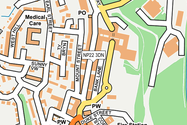
NP22 3DN lies on Commercial Street in Tredegar. NP22 3DN is located in the Tredegar electoral ward, within the unitary authority of Blaenau Gwent and the Welsh Parliamentary constituency of Blaenau Gwent. The Local Health Board is Aneurin Bevan University and the police force is Gwent. This postcode has been in use since June 1999.


GetTheData
Source: OS OpenMap – Local (Ordnance Survey)
Source: OS VectorMap District (Ordnance Survey)
Licence: Open Government Licence (requires attribution)
| Easting | 314122 |
| Northing | 209141 |
| Latitude | 51.774332 |
| Longitude | -3.246093 |
GetTheData
Source: Open Postcode Geo
Licence: Open Government Licence
| Street | Commercial Street |
| Town/City | Tredegar |
| Country | Wales |
| Postcode District | NP22 |
➜ See where NP22 is on a map ➜ Where is Tredegar? | |
GetTheData
Source: Land Registry Price Paid Data
Licence: Open Government Licence
Elevation or altitude of NP22 3DN as distance above sea level:
| Metres | Feet | |
|---|---|---|
| Elevation | 320m | 1,050ft |
Elevation is measured from the approximate centre of the postcode, to the nearest point on an OS contour line from OS Terrain 50, which has contour spacing of ten vertical metres.
➜ How high above sea level am I? Find the elevation of your current position using your device's GPS.
GetTheData
Source: Open Postcode Elevation
Licence: Open Government Licence
| Ward | Tredegar |
| Constituency | Blaenau Gwent |
GetTheData
Source: ONS Postcode Database
Licence: Open Government Licence
| Ty Scott (Earl Street) | Tredegar | 168m |
| Congregational Church (Queen Victoria Street) | Tredegar | 210m |
| Lidl (Stockton Way) | Tredegar | 210m |
| Congrgational Church (Queen Victoria Street) | Tredegar | 225m |
| Lidl (Stockton Way) | Tredegar | 233m |
| Ebbw Vale Town Station | 3km |
| Rhymney Station | 3.4km |
| Pontlottyn Station | 3.8km |
GetTheData
Source: NaPTAN
Licence: Open Government Licence
| Percentage of properties with Next Generation Access | 100.0% |
| Percentage of properties with Superfast Broadband | 100.0% |
| Percentage of properties with Ultrafast Broadband | 0.0% |
| Percentage of properties with Full Fibre Broadband | 0.0% |
Superfast Broadband is between 30Mbps and 300Mbps
Ultrafast Broadband is > 300Mbps
| Percentage of properties unable to receive 2Mbps | 0.0% |
| Percentage of properties unable to receive 5Mbps | 0.0% |
| Percentage of properties unable to receive 10Mbps | 0.0% |
| Percentage of properties unable to receive 30Mbps | 0.0% |
GetTheData
Source: Ofcom
Licence: Ofcom Terms of Use (requires attribution)
Estimated total energy consumption in NP22 3DN by fuel type, 2015.
| Consumption (kWh) | 86,834 |
|---|---|
| Meter count | 6 |
| Mean (kWh/meter) | 14,472 |
| Median (kWh/meter) | 11,377 |
GetTheData
Source: Postcode level gas estimates: 2015 (experimental)
Source: Postcode level electricity estimates: 2015 (experimental)
Licence: Open Government Licence
GetTheData
Source: ONS Postcode Database
Licence: Open Government Licence


➜ Get more ratings from the Food Standards Agency
GetTheData
Source: Food Standards Agency
Licence: FSA terms & conditions
| Last Collection | |||
|---|---|---|---|
| Location | Mon-Fri | Sat | Distance |
| Alma Street | 16:45 | 11:45 | 3,103m |
| Marine Street | 16:30 | 11:00 | 6,203m |
GetTheData
Source: Dracos
Licence: Creative Commons Attribution-ShareAlike
The below table lists the International Territorial Level (ITL) codes (formerly Nomenclature of Territorial Units for Statistics (NUTS) codes) and Local Administrative Units (LAU) codes for NP22 3DN:
| ITL 1 Code | Name |
|---|---|
| TLL | Wales |
| ITL 2 Code | Name |
| TLL1 | West Wales and The Valleys |
| ITL 3 Code | Name |
| TLL16 | Gwent Valleys |
| LAU 1 Code | Name |
| W06000019 | Blaenau Gwent |
GetTheData
Source: ONS Postcode Directory
Licence: Open Government Licence
The below table lists the Census Output Area (OA), Lower Layer Super Output Area (LSOA), and Middle Layer Super Output Area (MSOA) for NP22 3DN:
| Code | Name | |
|---|---|---|
| OA | W00007720 | |
| LSOA | W01001481 | Blaenau Gwent 006E |
| MSOA | W02000319 | Blaenau Gwent 006 |
GetTheData
Source: ONS Postcode Directory
Licence: Open Government Licence
| NP22 3DH | Commercial Street | 35m |
| NP22 3DW | Commercial Street | 84m |
| NP22 3DJ | Commercial Street | 89m |
| NP22 3QN | Ty Bryn | 110m |
| NP22 3QJ | Aneurin Rise | 135m |
| NP22 3QS | Earl Street | 159m |
| NP22 3QT | Sunny View | 191m |
| NP22 3PX | Queen Victoria Street | 194m |
| NP22 3QU | Rear Earl Street | 203m |
| NP22 3DG | Castle Street | 213m |
GetTheData
Source: Open Postcode Geo; Land Registry Price Paid Data
Licence: Open Government Licence