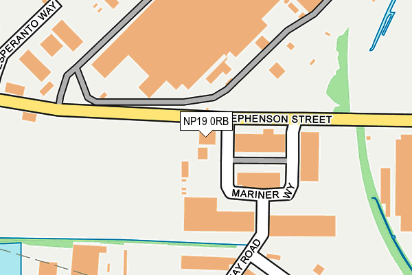
NP19 0RB is located in the Llanwern electoral ward, within the unitary authority of Newport and the Welsh Parliamentary constituency of Newport East. The Local Health Board is Aneurin Bevan University and the police force is Gwent. This postcode has been in use since June 1999.


GetTheData
Source: OS OpenMap – Local (Ordnance Survey)
Source: OS VectorMap District (Ordnance Survey)
Licence: Open Government Licence (requires attribution)
| Easting | 332048 |
| Northing | 186118 |
| Latitude | 51.569822 |
| Longitude | -2.981838 |
GetTheData
Source: Open Postcode Geo
Licence: Open Government Licence
| Country | Wales |
| Postcode District | NP19 |
➜ See where NP19 is on a map ➜ Where is Newport? | |
GetTheData
Source: Land Registry Price Paid Data
Licence: Open Government Licence
Elevation or altitude of NP19 0RB as distance above sea level:
| Metres | Feet | |
|---|---|---|
| Elevation | 10m | 33ft |
Elevation is measured from the approximate centre of the postcode, to the nearest point on an OS contour line from OS Terrain 50, which has contour spacing of ten vertical metres.
➜ How high above sea level am I? Find the elevation of your current position using your device's GPS.
GetTheData
Source: Open Postcode Elevation
Licence: Open Government Licence
| Ward | Llanwern |
| Constituency | Newport East |
GetTheData
Source: ONS Postcode Database
Licence: Open Government Licence
| Weight And Measures Office (Mariner Way) | Liswerry | 338m |
| Felnex Industrial Estate (Mariner Way) | Liswerry | 387m |
| St Stephen`s Church (Alexandra Road) | Pillgwenlly | 703m |
| St Stephen`s Church (Alexandra Road) | Pillgwenlly | 718m |
| Cambrian Inn (Commercial Road) | Pillgwenlly | 779m |
| Newport (S Wales) Station | 2.5km |
GetTheData
Source: NaPTAN
Licence: Open Government Licence
| Percentage of properties with Next Generation Access | 100.0% |
| Percentage of properties with Superfast Broadband | 100.0% |
| Percentage of properties with Ultrafast Broadband | 0.0% |
| Percentage of properties with Full Fibre Broadband | 0.0% |
Superfast Broadband is between 30Mbps and 300Mbps
Ultrafast Broadband is > 300Mbps
| Percentage of properties unable to receive 2Mbps | 0.0% |
| Percentage of properties unable to receive 5Mbps | 0.0% |
| Percentage of properties unable to receive 10Mbps | 0.0% |
| Percentage of properties unable to receive 30Mbps | 0.0% |
GetTheData
Source: Ofcom
Licence: Ofcom Terms of Use (requires attribution)
GetTheData
Source: ONS Postcode Database
Licence: Open Government Licence


➜ Get more ratings from the Food Standards Agency
GetTheData
Source: Food Standards Agency
Licence: FSA terms & conditions
| Last Collection | |||
|---|---|---|---|
| Location | Mon-Fri | Sat | Distance |
| Alexandra Post Office | 18:30 | 12:00 | 553m |
| Alexandra Road | 18:30 | 12:00 | 725m |
| Capel Street | 18:30 | 12:00 | 893m |
GetTheData
Source: Dracos
Licence: Creative Commons Attribution-ShareAlike
The below table lists the International Territorial Level (ITL) codes (formerly Nomenclature of Territorial Units for Statistics (NUTS) codes) and Local Administrative Units (LAU) codes for NP19 0RB:
| ITL 1 Code | Name |
|---|---|
| TLL | Wales |
| ITL 2 Code | Name |
| TLL2 | East Wales |
| ITL 3 Code | Name |
| TLL21 | Monmouthshire and Newport |
| LAU 1 Code | Name |
| W06000022 | Newport |
GetTheData
Source: ONS Postcode Directory
Licence: Open Government Licence
The below table lists the Census Output Area (OA), Lower Layer Super Output Area (LSOA), and Middle Layer Super Output Area (MSOA) for NP19 0RB:
| Code | Name | |
|---|---|---|
| OA | W00008558 | |
| LSOA | W01001647 | Newport 015F |
| MSOA | W02000361 | Newport 015 |
GetTheData
Source: ONS Postcode Directory
Licence: Open Government Licence
| NP20 2JU | Watch House Parade | 480m |
| NP20 2JG | Alexandra Road | 550m |
| NP20 2JH | Watch House Parade | 551m |
| NP20 2JT | Brunel Street | 558m |
| NP20 2JQ | Mill Parade | 605m |
| NP20 2HY | Wolseley Close | 614m |
| NP20 2JF | Alexandra Road | 631m |
| NP20 2JL | Milman Street | 632m |
| NP20 2HP | Wolseley Street | 638m |
| NP20 2JD | Carlisle Street | 641m |
GetTheData
Source: Open Postcode Geo; Land Registry Price Paid Data
Licence: Open Government Licence