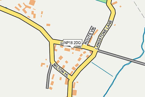
NP18 2DQ lies on Lodge Hill in Llanwern, Newport. NP18 2DQ is located in the Llanwern electoral ward, within the unitary authority of Newport and the Welsh Parliamentary constituency of Newport East. The Local Health Board is Aneurin Bevan University and the police force is Gwent. This postcode has been in use since June 1999.


GetTheData
Source: OS OpenMap – Local (Ordnance Survey)
Source: OS VectorMap District (Ordnance Survey)
Licence: Open Government Licence (requires attribution)
| Easting | 336763 |
| Northing | 188379 |
| Latitude | 51.590698 |
| Longitude | -2.914225 |
GetTheData
Source: Open Postcode Geo
Licence: Open Government Licence
| Street | Lodge Hill |
| Locality | Llanwern |
| Town/City | Newport |
| Country | Wales |
| Postcode District | NP18 |
➜ See where NP18 is on a map ➜ Where is Llanwern? | |
GetTheData
Source: Land Registry Price Paid Data
Licence: Open Government Licence
Elevation or altitude of NP18 2DQ as distance above sea level:
| Metres | Feet | |
|---|---|---|
| Elevation | 20m | 66ft |
Elevation is measured from the approximate centre of the postcode, to the nearest point on an OS contour line from OS Terrain 50, which has contour spacing of ten vertical metres.
➜ How high above sea level am I? Find the elevation of your current position using your device's GPS.
GetTheData
Source: Open Postcode Elevation
Licence: Open Government Licence
| Ward | Llanwern |
| Constituency | Newport East |
GetTheData
Source: ONS Postcode Database
Licence: Open Government Licence
STRAY LEAVES, LODGE HILL, LLANWERN, NEWPORT, NP18 2DQ 2020 24 AUG £499,000 |
STRAY LEAVES, LODGE HILL, LLANWERN, NEWPORT, NP18 2DQ 2015 16 JUL £380,000 |
OAKDENE, 3, LODGE HILL, LLANWERN, NEWPORT, NP18 2DQ 2015 8 MAY £255,000 |
2014 22 DEC £160,000 |
2007 8 OCT £236,000 |
TALL TREES, 4, LODGE HILL, LLANWERN, NEWPORT, NP18 2DQ 2001 4 MAY £119,950 |
STRAY LEAVES, LODGE HILL, LLANWERN, NEWPORT, NP18 2DQ 2000 23 JUN £179,000 |
TALL TREES, 4, LODGE HILL, LLANWERN, NEWPORT, NP18 2DQ 1997 19 AUG £115,000 |
GetTheData
Source: HM Land Registry Price Paid Data
Licence: Contains HM Land Registry data © Crown copyright and database right 2025. This data is licensed under the Open Government Licence v3.0.
| Milton Hotel (Station Road) | Llanwern | 147m |
| Milton Hotel (Station Road) | Llanwern | 150m |
| Llanwern Village (Station Road) | Llanwern | 728m |
| Sterndale Bennett Road (Hendre Farm Drive) | Ringland | 936m |
| Playford Crescent (Hendre Farm Drive) | Ringland | 949m |
GetTheData
Source: NaPTAN
Licence: Open Government Licence
| Percentage of properties with Next Generation Access | 0.0% |
| Percentage of properties with Superfast Broadband | 0.0% |
| Percentage of properties with Ultrafast Broadband | 0.0% |
| Percentage of properties with Full Fibre Broadband | 0.0% |
Superfast Broadband is between 30Mbps and 300Mbps
Ultrafast Broadband is > 300Mbps
| Percentage of properties unable to receive 2Mbps | 0.0% |
| Percentage of properties unable to receive 5Mbps | 0.0% |
| Percentage of properties unable to receive 10Mbps | 0.0% |
| Percentage of properties unable to receive 30Mbps | 100.0% |
GetTheData
Source: Ofcom
Licence: Ofcom Terms of Use (requires attribution)
GetTheData
Source: ONS Postcode Database
Licence: Open Government Licence


➜ Get more ratings from the Food Standards Agency
GetTheData
Source: Food Standards Agency
Licence: FSA terms & conditions
| Last Collection | |||
|---|---|---|---|
| Location | Mon-Fri | Sat | Distance |
| Nelson Drive | 17:30 | 11:45 | 1,266m |
| The Priory Langstone | 16:00 | 11:00 | 2,073m |
| Aberthaw Circle | 17:30 | 11:15 | 3,361m |
GetTheData
Source: Dracos
Licence: Creative Commons Attribution-ShareAlike
The below table lists the International Territorial Level (ITL) codes (formerly Nomenclature of Territorial Units for Statistics (NUTS) codes) and Local Administrative Units (LAU) codes for NP18 2DQ:
| ITL 1 Code | Name |
|---|---|
| TLL | Wales |
| ITL 2 Code | Name |
| TLL2 | East Wales |
| ITL 3 Code | Name |
| TLL21 | Monmouthshire and Newport |
| LAU 1 Code | Name |
| W06000022 | Newport |
GetTheData
Source: ONS Postcode Directory
Licence: Open Government Licence
The below table lists the Census Output Area (OA), Lower Layer Super Output Area (LSOA), and Middle Layer Super Output Area (MSOA) for NP18 2DQ:
| Code | Name | |
|---|---|---|
| OA | W00008568 | |
| LSOA | W01001649 | Newport 004D |
| MSOA | W02000350 | Newport 004 |
GetTheData
Source: ONS Postcode Directory
Licence: Open Government Licence
| NP18 2DS | 51m | |
| NP18 2DU | Milton Hill | 84m |
| NP18 2DR | Routes View | 93m |
| NP18 2DN | Bishton Road | 352m |
| NP18 2DW | Station Road | 439m |
| NP18 2DP | Cot Hill | 447m |
| NP18 2NG | Langstone Court Road | 556m |
| NP18 2DX | Dockwell Terrace | 633m |
| NP19 9JE | Linley Close | 694m |
| NP19 9JD | Halle Close | 702m |
GetTheData
Source: Open Postcode Geo; Land Registry Price Paid Data
Licence: Open Government Licence