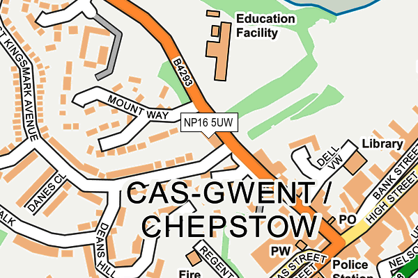
NP16 5UW lies on Welsh Street in Chepstow. NP16 5UW is located in the St Kingsmark electoral ward, within the unitary authority of Monmouthshire and the Welsh Parliamentary constituency of Monmouth. The Local Health Board is Aneurin Bevan University and the police force is Gwent. This postcode has been in use since June 1999.


GetTheData
Source: OS OpenMap – Local (Ordnance Survey)
Source: OS VectorMap District (Ordnance Survey)
Licence: Open Government Licence (requires attribution)
| Easting | 353079 |
| Northing | 193930 |
| Latitude | 51.642202 |
| Longitude | -2.679464 |
GetTheData
Source: Open Postcode Geo
Licence: Open Government Licence
| Street | Welsh Street |
| Town/City | Chepstow |
| Country | Wales |
| Postcode District | NP16 |
➜ See where NP16 is on a map ➜ Where is Chepstow? | |
GetTheData
Source: Land Registry Price Paid Data
Licence: Open Government Licence
Elevation or altitude of NP16 5UW as distance above sea level:
| Metres | Feet | |
|---|---|---|
| Elevation | 50m | 164ft |
Elevation is measured from the approximate centre of the postcode, to the nearest point on an OS contour line from OS Terrain 50, which has contour spacing of ten vertical metres.
➜ How high above sea level am I? Find the elevation of your current position using your device's GPS.
GetTheData
Source: Open Postcode Elevation
Licence: Open Government Licence
| Ward | St Kingsmark |
| Constituency | Monmouth |
GetTheData
Source: ONS Postcode Database
Licence: Open Government Licence
YORK HOUSE, WELSH STREET, CHEPSTOW, NP16 5UW 2000 28 MAR £92,125 |
GetTheData
Source: HM Land Registry Price Paid Data
Licence: Contains HM Land Registry data © Crown copyright and database right 2025. This data is licensed under the Open Government Licence v3.0.
| St Kingsmark Avenue (Welsh Street) | Chepstow | 35m |
| St Kingsmark Avenue (Welsh Street) | Chepstow | 40m |
| High Street | Chepstow | 296m |
| Beaufort Square | Chepstow | 323m |
| Vauxhall Road Surgery (Vauxhall Road) | Hardwick Village | 347m |
| Chepstow Station | 0.6km |
GetTheData
Source: NaPTAN
Licence: Open Government Licence
GetTheData
Source: ONS Postcode Database
Licence: Open Government Licence


➜ Get more ratings from the Food Standards Agency
GetTheData
Source: Food Standards Agency
Licence: FSA terms & conditions
| Last Collection | |||
|---|---|---|---|
| Location | Mon-Fri | Sat | Distance |
| St Annes Street | 16:00 | 12:00 | 621m |
| Tutshill | 16:30 | 11:15 | 1,302m |
| Elm Road | 16:15 | 11:15 | 1,409m |
GetTheData
Source: Dracos
Licence: Creative Commons Attribution-ShareAlike
The below table lists the International Territorial Level (ITL) codes (formerly Nomenclature of Territorial Units for Statistics (NUTS) codes) and Local Administrative Units (LAU) codes for NP16 5UW:
| ITL 1 Code | Name |
|---|---|
| TLL | Wales |
| ITL 2 Code | Name |
| TLL2 | East Wales |
| ITL 3 Code | Name |
| TLL21 | Monmouthshire and Newport |
| LAU 1 Code | Name |
| W06000021 | Monmouthshire |
GetTheData
Source: ONS Postcode Directory
Licence: Open Government Licence
The below table lists the Census Output Area (OA), Lower Layer Super Output Area (LSOA), and Middle Layer Super Output Area (MSOA) for NP16 5UW:
| Code | Name | |
|---|---|---|
| OA | W00008261 | |
| LSOA | W01001587 | Monmouthshire 008C |
| MSOA | W02000343 | Monmouthshire 008 |
GetTheData
Source: ONS Postcode Directory
Licence: Open Government Licence
| NP16 5LR | Welsh Street | 39m |
| NP16 5LP | Huntfield Cottages | 49m |
| NP16 5LN | Welsh Street | 108m |
| NP16 5SN | St Kingsmark Avenue | 141m |
| NP16 5JA | Dell View | 141m |
| NP16 5NF | Mount Way | 161m |
| NP16 5AT | Deans Hill | 174m |
| NP16 5DH | Thomas Street | 198m |
| NP16 5UJ | The Mount | 199m |
| NP16 5LL | Welsh Street | 209m |
GetTheData
Source: Open Postcode Geo; Land Registry Price Paid Data
Licence: Open Government Licence