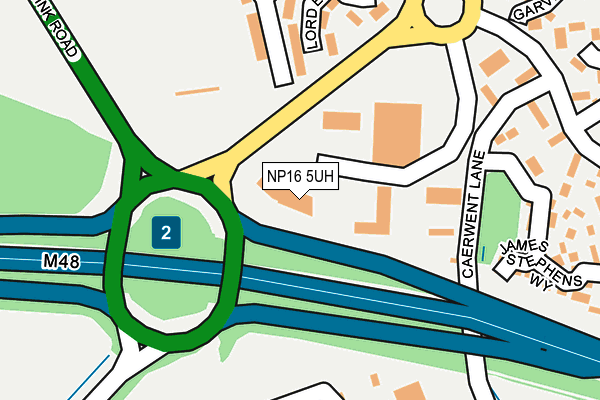
NP16 5UH is located in the Bulwark and Thornwell electoral ward, within the unitary authority of Monmouthshire and the Welsh Parliamentary constituency of Monmouth. The Local Health Board is Aneurin Bevan University and the police force is Gwent. This postcode has been in use since August 2006.


GetTheData
Source: OS OpenMap – Local (Ordnance Survey)
Source: OS VectorMap District (Ordnance Survey)
Licence: Open Government Licence (requires attribution)
| Easting | 353735 |
| Northing | 191670 |
| Latitude | 51.621939 |
| Longitude | -2.669692 |
GetTheData
Source: Open Postcode Geo
Licence: Open Government Licence
| Country | Wales |
| Postcode District | NP16 |
➜ See where NP16 is on a map ➜ Where is Chepstow? | |
GetTheData
Source: Land Registry Price Paid Data
Licence: Open Government Licence
Elevation or altitude of NP16 5UH as distance above sea level:
| Metres | Feet | |
|---|---|---|
| Elevation | 30m | 98ft |
Elevation is measured from the approximate centre of the postcode, to the nearest point on an OS contour line from OS Terrain 50, which has contour spacing of ten vertical metres.
➜ How high above sea level am I? Find the elevation of your current position using your device's GPS.
GetTheData
Source: Open Postcode Elevation
Licence: Open Government Licence
| Ward | Bulwark And Thornwell |
| Constituency | Monmouth |
GetTheData
Source: ONS Postcode Database
Licence: Open Government Licence
| Conway Drive (Link Road) | Chepstow | 86m |
| Conway Drive (Link Road) | Chepstow | 96m |
| Old Farm Shopping Centre (Mariners Reach) | Bulwark | 165m |
| Thornwell Schools (Thornwell Road) | Bulwark | 281m |
| Thornwell Schools (Thornwell Road) | Bulwark | 307m |
| Chepstow Station | 2km |
GetTheData
Source: NaPTAN
Licence: Open Government Licence
GetTheData
Source: ONS Postcode Database
Licence: Open Government Licence


➜ Get more ratings from the Food Standards Agency
GetTheData
Source: Food Standards Agency
Licence: FSA terms & conditions
| Last Collection | |||
|---|---|---|---|
| Location | Mon-Fri | Sat | Distance |
| Sedbury Post Office | 17:15 | 11:15 | 2,141m |
| St Annes Street | 16:00 | 12:00 | 2,585m |
| Tutshill | 16:30 | 11:15 | 3,076m |
GetTheData
Source: Dracos
Licence: Creative Commons Attribution-ShareAlike
The below table lists the International Territorial Level (ITL) codes (formerly Nomenclature of Territorial Units for Statistics (NUTS) codes) and Local Administrative Units (LAU) codes for NP16 5UH:
| ITL 1 Code | Name |
|---|---|
| TLL | Wales |
| ITL 2 Code | Name |
| TLL2 | East Wales |
| ITL 3 Code | Name |
| TLL21 | Monmouthshire and Newport |
| LAU 1 Code | Name |
| W06000021 | Monmouthshire |
GetTheData
Source: ONS Postcode Directory
Licence: Open Government Licence
The below table lists the Census Output Area (OA), Lower Layer Super Output Area (LSOA), and Middle Layer Super Output Area (MSOA) for NP16 5UH:
| Code | Name | |
|---|---|---|
| OA | W00008298 | |
| LSOA | W01001592 | Monmouthshire 008D |
| MSOA | W02000343 | Monmouthshire 008 |
GetTheData
Source: ONS Postcode Directory
Licence: Open Government Licence
| NP16 5GB | Samuel Rodgers Crescent | 144m |
| NP16 5SZ | Fountain Way | 182m |
| NP16 5TD | Garvey Close | 185m |
| NP16 5GE | James Stephens Way | 203m |
| NP16 5TB | Preston Close | 203m |
| NP16 5RY | Cider Mill Close | 219m |
| NP16 5TA | Lewis Way | 246m |
| NP16 5RX | The Hop Garden | 254m |
| NP16 5NR | Somerset Way | 261m |
| NP16 5GF | John Rastrick Rise | 271m |
GetTheData
Source: Open Postcode Geo; Land Registry Price Paid Data
Licence: Open Government Licence