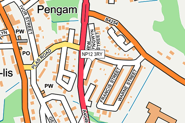
NP12 3RY lies on New Bryngwyn Street in Fleur De Lis, Blackwood. NP12 3RY is located in the Cefn Fforest and Pengam electoral ward, within the unitary authority of Caerphilly and the Welsh Parliamentary constituency of Islwyn. The Local Health Board is Aneurin Bevan University and the police force is Gwent. This postcode has been in use since June 1999.


GetTheData
Source: OS OpenMap – Local (Ordnance Survey)
Source: OS VectorMap District (Ordnance Survey)
Licence: Open Government Licence (requires attribution)
| Easting | 315797 |
| Northing | 196657 |
| Latitude | 51.662365 |
| Longitude | -3.218800 |
GetTheData
Source: Open Postcode Geo
Licence: Open Government Licence
| Street | New Bryngwyn Street |
| Locality | Fleur De Lis |
| Town/City | Blackwood |
| Country | Wales |
| Postcode District | NP12 |
➜ See where NP12 is on a map ➜ Where is Fleur-de-lis? | |
GetTheData
Source: Land Registry Price Paid Data
Licence: Open Government Licence
Elevation or altitude of NP12 3RY as distance above sea level:
| Metres | Feet | |
|---|---|---|
| Elevation | 160m | 525ft |
Elevation is measured from the approximate centre of the postcode, to the nearest point on an OS contour line from OS Terrain 50, which has contour spacing of ten vertical metres.
➜ How high above sea level am I? Find the elevation of your current position using your device's GPS.
GetTheData
Source: Open Postcode Elevation
Licence: Open Government Licence
| Ward | Cefn Fforest And Pengam |
| Constituency | Islwyn |
GetTheData
Source: ONS Postcode Database
Licence: Open Government Licence
| Bryngwyn Street (A4049) | Fleur-de-lis | 31m |
| Bryngwyn Street (A4049) | Fleur-de-lis | 44m |
| Gwent Court (High Street) | Fleur-de-lis | 236m |
| Gwent Court (High Street) | Fleur-de-lis | 256m |
| Ysgol Gufyn Cwm Rhymni (A4049) | Fleur-de-lis | 269m |
| Pengam Station | 1.2km |
| Hengoed Station | 1.7km |
| Gilfach Fargoed Station | 2.5km |
GetTheData
Source: NaPTAN
Licence: Open Government Licence
| Percentage of properties with Next Generation Access | 100.0% |
| Percentage of properties with Superfast Broadband | 100.0% |
| Percentage of properties with Ultrafast Broadband | 0.0% |
| Percentage of properties with Full Fibre Broadband | 0.0% |
Superfast Broadband is between 30Mbps and 300Mbps
Ultrafast Broadband is > 300Mbps
| Median download speed | 58.0Mbps |
| Average download speed | 56.1Mbps |
| Maximum download speed | 61.43Mbps |
| Median upload speed | 18.4Mbps |
| Average upload speed | 18.2Mbps |
| Maximum upload speed | 19.76Mbps |
| Percentage of properties unable to receive 2Mbps | 0.0% |
| Percentage of properties unable to receive 5Mbps | 0.0% |
| Percentage of properties unable to receive 10Mbps | 0.0% |
| Percentage of properties unable to receive 30Mbps | 0.0% |
GetTheData
Source: Ofcom
Licence: Ofcom Terms of Use (requires attribution)
GetTheData
Source: ONS Postcode Database
Licence: Open Government Licence


➜ Get more ratings from the Food Standards Agency
GetTheData
Source: Food Standards Agency
Licence: FSA terms & conditions
| Last Collection | |||
|---|---|---|---|
| Location | Mon-Fri | Sat | Distance |
| Fleur De Lys Post Office | 17:00 | 12:00 | 232m |
| Fleur De Lys Village | 16:00 | 11:00 | 529m |
| St Davids Industrial Estate | 16:15 | 11:00 | 741m |
GetTheData
Source: Dracos
Licence: Creative Commons Attribution-ShareAlike
The below table lists the International Territorial Level (ITL) codes (formerly Nomenclature of Territorial Units for Statistics (NUTS) codes) and Local Administrative Units (LAU) codes for NP12 3RY:
| ITL 1 Code | Name |
|---|---|
| TLL | Wales |
| ITL 2 Code | Name |
| TLL1 | West Wales and The Valleys |
| ITL 3 Code | Name |
| TLL16 | Gwent Valleys |
| LAU 1 Code | Name |
| W06000018 | Caerphilly |
GetTheData
Source: ONS Postcode Directory
Licence: Open Government Licence
The below table lists the Census Output Area (OA), Lower Layer Super Output Area (LSOA), and Middle Layer Super Output Area (MSOA) for NP12 3RY:
| Code | Name | |
|---|---|---|
| OA | W00007269 | |
| LSOA | W01001389 | Caerphilly 007E |
| MSOA | W02000296 | Caerphilly 007 |
GetTheData
Source: ONS Postcode Directory
Licence: Open Government Licence
| NP12 3RP | Plas Terrace | 40m |
| NP12 3RW | Oak Terrace | 66m |
| NP12 3RL | New Road | 70m |
| NP12 3RZ | Bryn Gwyn | 74m |
| NP12 3SE | Plas Road | 83m |
| NP12 3SB | Leonard Street | 90m |
| NP12 3RU | Francis Street | 96m |
| NP12 3SD | Plasgwyn Terrace | 100m |
| NP12 3RX | Francis Street | 100m |
| NP12 3RN | 102m |
GetTheData
Source: Open Postcode Geo; Land Registry Price Paid Data
Licence: Open Government Licence