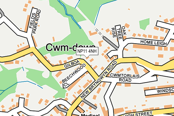
NP11 4NH lies on Gilboa Road in Newbridge, Newport. NP11 4NH is located in the Newbridge electoral ward, within the unitary authority of Caerphilly and the Welsh Parliamentary constituency of Islwyn. The Local Health Board is Aneurin Bevan University and the police force is Gwent. This postcode has been in use since June 1999.


GetTheData
Source: OS OpenMap – Local (Ordnance Survey)
Source: OS VectorMap District (Ordnance Survey)
Licence: Open Government Licence (requires attribution)
| Easting | 320244 |
| Northing | 196946 |
| Latitude | 51.665609 |
| Longitude | -3.154577 |
GetTheData
Source: Open Postcode Geo
Licence: Open Government Licence
| Street | Gilboa Road |
| Locality | Newbridge |
| Town/City | Newport |
| Country | Wales |
| Postcode District | NP11 |
➜ See where NP11 is on a map ➜ Where is Newbridge? | |
GetTheData
Source: Land Registry Price Paid Data
Licence: Open Government Licence
Elevation or altitude of NP11 4NH as distance above sea level:
| Metres | Feet | |
|---|---|---|
| Elevation | 150m | 492ft |
Elevation is measured from the approximate centre of the postcode, to the nearest point on an OS contour line from OS Terrain 50, which has contour spacing of ten vertical metres.
➜ How high above sea level am I? Find the elevation of your current position using your device's GPS.
GetTheData
Source: Open Postcode Elevation
Licence: Open Government Licence
| Ward | Newbridge |
| Constituency | Islwyn |
GetTheData
Source: ONS Postcode Database
Licence: Open Government Licence
BELLA VISTA, GILBOA ROAD, NEWBRIDGE, NEWPORT, NP11 4NH 2001 13 JUL £65,000 |
GetTheData
Source: HM Land Registry Price Paid Data
Licence: Contains HM Land Registry data © Crown copyright and database right 2025. This data is licensed under the Open Government Licence v3.0.
| Martins Field (New Bryngwyn Road) | Newbridge | 86m |
| Martins Field (New Bryngwyn Road) | Newbridge | 97m |
| Bryngwyn Nursing Home (New Bryngwyn Road) | Newbridge | 176m |
| Mountleigh Nursing Home (New Bryngwyn Road) | Newbridge | 205m |
| Red Lion (Bryngwyn Road) | Newbridge | 233m |
| Newbridge Station | 0.8km |
| Llanhilleth Station | 4.1km |
| Hengoed Station | 5.2km |
GetTheData
Source: NaPTAN
Licence: Open Government Licence
| Percentage of properties with Next Generation Access | 100.0% |
| Percentage of properties with Superfast Broadband | 100.0% |
| Percentage of properties with Ultrafast Broadband | 0.0% |
| Percentage of properties with Full Fibre Broadband | 0.0% |
Superfast Broadband is between 30Mbps and 300Mbps
Ultrafast Broadband is > 300Mbps
| Percentage of properties unable to receive 2Mbps | 0.0% |
| Percentage of properties unable to receive 5Mbps | 0.0% |
| Percentage of properties unable to receive 10Mbps | 0.0% |
| Percentage of properties unable to receive 30Mbps | 0.0% |
GetTheData
Source: Ofcom
Licence: Ofcom Terms of Use (requires attribution)
GetTheData
Source: ONS Postcode Database
Licence: Open Government Licence


➜ Get more ratings from the Food Standards Agency
GetTheData
Source: Food Standards Agency
Licence: FSA terms & conditions
| Last Collection | |||
|---|---|---|---|
| Location | Mon-Fri | Sat | Distance |
| Newbridge Post Office | 17:00 | 11:45 | 740m |
| Pentwynmawr | 16:00 | 11:30 | 959m |
| Blackwood Post Office | 18:00 | 12:30 | 2,799m |
GetTheData
Source: Dracos
Licence: Creative Commons Attribution-ShareAlike
The below table lists the International Territorial Level (ITL) codes (formerly Nomenclature of Territorial Units for Statistics (NUTS) codes) and Local Administrative Units (LAU) codes for NP11 4NH:
| ITL 1 Code | Name |
|---|---|
| TLL | Wales |
| ITL 2 Code | Name |
| TLL1 | West Wales and The Valleys |
| ITL 3 Code | Name |
| TLL16 | Gwent Valleys |
| LAU 1 Code | Name |
| W06000018 | Caerphilly |
GetTheData
Source: ONS Postcode Directory
Licence: Open Government Licence
The below table lists the Census Output Area (OA), Lower Layer Super Output Area (LSOA), and Middle Layer Super Output Area (MSOA) for NP11 4NH:
| Code | Name | |
|---|---|---|
| OA | W00007244 | |
| LSOA | W01001382 | Caerphilly 010C |
| MSOA | W02000299 | Caerphilly 010 |
GetTheData
Source: ONS Postcode Directory
Licence: Open Government Licence
| NP11 4NU | Gilboa Road | 34m |
| NP11 4NN | Gilboa Road | 62m |
| NP11 4NX | Beechwood Close | 86m |
| NP11 4RH | Oak Tree Rise | 125m |
| NP11 4NL | The Villas | 128m |
| NP11 4LY | Cwmtorlais Road | 152m |
| NP11 4NF | New Bryngwyn Road | 161m |
| NP11 4NJ | Gilboa Road | 165m |
| NP11 4NA | Cwmdows Terrace | 174m |
| NP11 4ND | Twyn Gwyn Terrace | 204m |
GetTheData
Source: Open Postcode Geo; Land Registry Price Paid Data
Licence: Open Government Licence