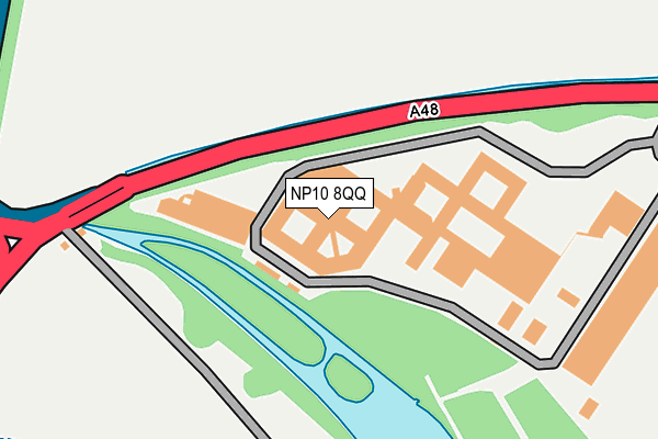
NP10 8QQ is located in the Tredegar Park and Marshfield electoral ward, within the unitary authority of Newport and the Welsh Parliamentary constituency of Newport West. The Local Health Board is Aneurin Bevan University and the police force is Gwent. This postcode has been in use since June 1999.


GetTheData
Source: OS OpenMap – Local (Ordnance Survey)
Source: OS VectorMap District (Ordnance Survey)
Licence: Open Government Licence (requires attribution)
| Easting | 328727 |
| Northing | 185815 |
| Latitude | 51.566685 |
| Longitude | -3.029678 |
GetTheData
Source: Open Postcode Geo
Licence: Open Government Licence
| Country | Wales |
| Postcode District | NP10 |
➜ See where NP10 is on a map ➜ Where is Newport? | |
GetTheData
Source: Land Registry Price Paid Data
Licence: Open Government Licence
Elevation or altitude of NP10 8QQ as distance above sea level:
| Metres | Feet | |
|---|---|---|
| Elevation | 20m | 66ft |
Elevation is measured from the approximate centre of the postcode, to the nearest point on an OS contour line from OS Terrain 50, which has contour spacing of ten vertical metres.
➜ How high above sea level am I? Find the elevation of your current position using your device's GPS.
GetTheData
Source: Open Postcode Elevation
Licence: Open Government Licence
| Ward | Tredegar Park And Marshfield |
| Constituency | Newport West |
GetTheData
Source: ONS Postcode Database
Licence: Open Government Licence
| Tredegar Park (Cardiff Road) | Newport | 226m |
| Tredegar Park (Cardiff Road) | Newport | 445m |
| Office Of National Statistics (Entrance) | Pont Ebbw | 527m |
| Kestrel Way (Duffryn Drive) | Duffryn | 544m |
| Kingfisher Place (Duffryn Drive) | Newport | 580m |
| Newport (S Wales) Station | 3.2km |
| Rogerstone Station | 4.1km |
| Risca & Pontymister Station | 6.1km |
GetTheData
Source: NaPTAN
Licence: Open Government Licence
GetTheData
Source: ONS Postcode Database
Licence: Open Government Licence


➜ Get more ratings from the Food Standards Agency
GetTheData
Source: Food Standards Agency
Licence: FSA terms & conditions
| Last Collection | |||
|---|---|---|---|
| Location | Mon-Fri | Sat | Distance |
| Lamb Close | 17:30 | 12:00 | 851m |
| Cardiff Road Post Office | 17:30 | 12:30 | 1,302m |
| Morgraig Avenue | 16:45 | 12:00 | 1,378m |
GetTheData
Source: Dracos
Licence: Creative Commons Attribution-ShareAlike
The below table lists the International Territorial Level (ITL) codes (formerly Nomenclature of Territorial Units for Statistics (NUTS) codes) and Local Administrative Units (LAU) codes for NP10 8QQ:
| ITL 1 Code | Name |
|---|---|
| TLL | Wales |
| ITL 2 Code | Name |
| TLL2 | East Wales |
| ITL 3 Code | Name |
| TLL21 | Monmouthshire and Newport |
| LAU 1 Code | Name |
| W06000022 | Newport |
GetTheData
Source: ONS Postcode Directory
Licence: Open Government Licence
The below table lists the Census Output Area (OA), Lower Layer Super Output Area (LSOA), and Middle Layer Super Output Area (MSOA) for NP10 8QQ:
| Code | Name | |
|---|---|---|
| OA | W00009863 | |
| LSOA | W01001913 | Newport 020F |
| MSOA | W02000366 | Newport 020 |
GetTheData
Source: ONS Postcode Directory
Licence: Open Government Licence
| NP10 8AG | Jamaica Walk | 593m |
| NP10 8AE | Jamaica Close | 596m |
| NP10 8AP | Jamaica Circle | 632m |
| NP10 8AN | Jamaica Circle | 646m |
| NP10 8AF | Jamaica Gardens | 650m |
| NP10 8WG | Kestrel Way | 688m |
| NP10 8WJ | Swallow Way | 689m |
| NP10 8AB | Jamaica Circle | 692m |
| NP20 3AR | Park Close | 696m |
| NP10 8AL | Jamaica Grove | 703m |
GetTheData
Source: Open Postcode Geo; Land Registry Price Paid Data
Licence: Open Government Licence