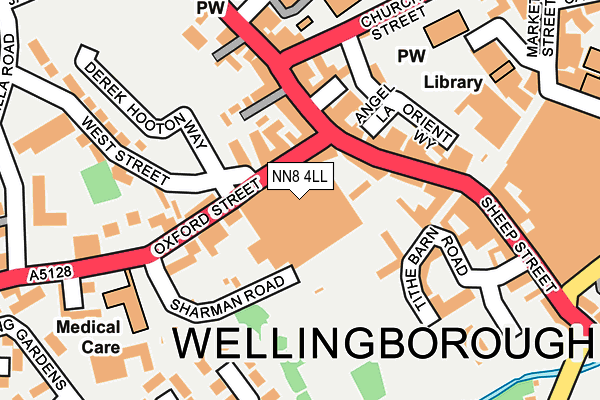
NN8 4LL is located in the Croyland and Swanspool electoral ward, within the unitary authority of North Northamptonshire and the English Parliamentary constituency of Wellingborough. The Sub Integrated Care Board (ICB) Location is NHS Northamptonshire ICB - 78H and the police force is Northamptonshire. This postcode has been in use since December 2000.


GetTheData
Source: OS OpenMap – Local (Ordnance Survey)
Source: OS VectorMap District (Ordnance Survey)
Licence: Open Government Licence (requires attribution)
| Easting | 489060 |
| Northing | 267766 |
| Latitude | 52.300820 |
| Longitude | -0.695347 |
GetTheData
Source: Open Postcode Geo
Licence: Open Government Licence
| Country | England |
| Postcode District | NN8 |
➜ See where NN8 is on a map ➜ Where is Wellingborough? | |
GetTheData
Source: Land Registry Price Paid Data
Licence: Open Government Licence
Elevation or altitude of NN8 4LL as distance above sea level:
| Metres | Feet | |
|---|---|---|
| Elevation | 60m | 197ft |
Elevation is measured from the approximate centre of the postcode, to the nearest point on an OS contour line from OS Terrain 50, which has contour spacing of ten vertical metres.
➜ How high above sea level am I? Find the elevation of your current position using your device's GPS.
GetTheData
Source: Open Postcode Elevation
Licence: Open Government Licence
| Ward | Croyland And Swanspool |
| Constituency | Wellingborough |
GetTheData
Source: ONS Postcode Database
Licence: Open Government Licence
| Morrisons (Oxford Street) | Wellingborough | 67m |
| Morrisons (Oxford Street) | Wellingborough | 155m |
| Sheep St (Sheep Street) | Wellingborough | 182m |
| Church Street Interchange (Church Street) | Wellingborough | 198m |
| Church Street Interchange (Church Street) | Wellingborough | 221m |
| Wellingborough Station | 1.3km |
GetTheData
Source: NaPTAN
Licence: Open Government Licence
GetTheData
Source: ONS Postcode Database
Licence: Open Government Licence


➜ Get more ratings from the Food Standards Agency
GetTheData
Source: Food Standards Agency
Licence: FSA terms & conditions
| Last Collection | |||
|---|---|---|---|
| Location | Mon-Fri | Sat | Distance |
| Morrison's Supermarket | 16:45 | 11:00 | 20m |
| Silver Street | 17:15 | 11:00 | 90m |
| Market Street | 16:45 | 11:00 | 181m |
GetTheData
Source: Dracos
Licence: Creative Commons Attribution-ShareAlike
The below table lists the International Territorial Level (ITL) codes (formerly Nomenclature of Territorial Units for Statistics (NUTS) codes) and Local Administrative Units (LAU) codes for NN8 4LL:
| ITL 1 Code | Name |
|---|---|
| TLF | East Midlands (England) |
| ITL 2 Code | Name |
| TLF2 | Leicestershire, Rutland and Northamptonshire |
| ITL 3 Code | Name |
| TLF25 | North Northamptonshire |
| LAU 1 Code | Name |
| E07000156 | Wellingborough |
GetTheData
Source: ONS Postcode Directory
Licence: Open Government Licence
The below table lists the Census Output Area (OA), Lower Layer Super Output Area (LSOA), and Middle Layer Super Output Area (MSOA) for NN8 4LL:
| Code | Name | |
|---|---|---|
| OA | E00139154 | |
| LSOA | E01027349 | Wellingborough 006A |
| MSOA | E02005697 | Wellingborough 006 |
GetTheData
Source: ONS Postcode Directory
Licence: Open Government Licence
| NN8 1BQ | Silver Street | 85m |
| NN8 4JJ | Oxford Street | 89m |
| NN8 1AY | Silver Street | 98m |
| NN8 4LA | Angel Lane | 123m |
| NN8 4HY | Oxford Street | 125m |
| NN8 4HJ | Church Way | 131m |
| NN8 4FA | High Street Mews | 144m |
| NN8 4HR | High Street | 148m |
| NN8 4HL | High Street | 149m |
| NN8 4JH | Oxford Street | 157m |
GetTheData
Source: Open Postcode Geo; Land Registry Price Paid Data
Licence: Open Government Licence