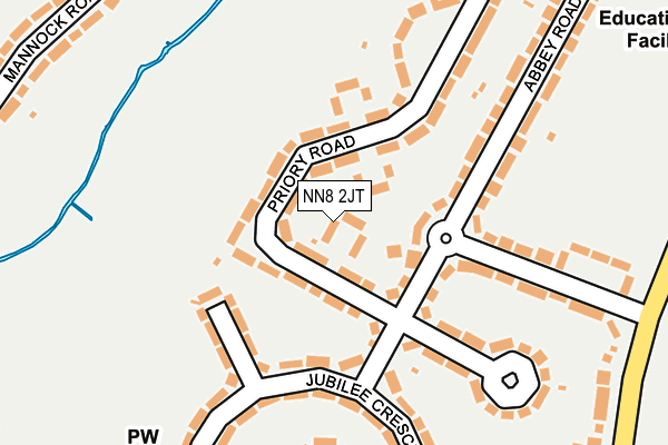
NN8 2JT lies on Priory Road in Wellingborough. NN8 2JT is located in the Croyland and Swanspool electoral ward, within the unitary authority of North Northamptonshire and the English Parliamentary constituency of Wellingborough. The Sub Integrated Care Board (ICB) Location is NHS Northamptonshire ICB - 78H and the police force is Northamptonshire. This postcode has been in use since January 1980.


GetTheData
Source: OS OpenMap – Local (Ordnance Survey)
Source: OS VectorMap District (Ordnance Survey)
Licence: Open Government Licence (requires attribution)
| Easting | 488709 |
| Northing | 267014 |
| Latitude | 52.294104 |
| Longitude | -0.700709 |
GetTheData
Source: Open Postcode Geo
Licence: Open Government Licence
| Street | Priory Road |
| Town/City | Wellingborough |
| Country | England |
| Postcode District | NN8 |
➜ See where NN8 is on a map ➜ Where is Wellingborough? | |
GetTheData
Source: Land Registry Price Paid Data
Licence: Open Government Licence
Elevation or altitude of NN8 2JT as distance above sea level:
| Metres | Feet | |
|---|---|---|
| Elevation | 60m | 197ft |
Elevation is measured from the approximate centre of the postcode, to the nearest point on an OS contour line from OS Terrain 50, which has contour spacing of ten vertical metres.
➜ How high above sea level am I? Find the elevation of your current position using your device's GPS.
GetTheData
Source: Open Postcode Elevation
Licence: Open Government Licence
| Ward | Croyland And Swanspool |
| Constituency | Wellingborough |
GetTheData
Source: ONS Postcode Database
Licence: Open Government Licence
| 206 Priory Road (Priory Road) | Wellingborough | 122m |
| 206 Priory Road (Priory Road) | Wellingborough | 127m |
| Lilley Homes (Abbey Road) | Wellingborough | 225m |
| Phone Box (Kingsway) | Wellingborough | 244m |
| Lilley Homes (Abbey Road) | Wellingborough | 246m |
| Wellingborough Station | 2km |
GetTheData
Source: NaPTAN
Licence: Open Government Licence
| Percentage of properties with Next Generation Access | 100.0% |
| Percentage of properties with Superfast Broadband | 79.2% |
| Percentage of properties with Ultrafast Broadband | 37.7% |
| Percentage of properties with Full Fibre Broadband | 0.0% |
Superfast Broadband is between 30Mbps and 300Mbps
Ultrafast Broadband is > 300Mbps
| Median download speed | 38.4Mbps |
| Average download speed | 61.8Mbps |
| Maximum download speed | 350.00Mbps |
| Median upload speed | 1.1Mbps |
| Average upload speed | 3.2Mbps |
| Maximum upload speed | 20.00Mbps |
| Percentage of properties unable to receive 2Mbps | 0.0% |
| Percentage of properties unable to receive 5Mbps | 0.0% |
| Percentage of properties unable to receive 10Mbps | 0.0% |
| Percentage of properties unable to receive 30Mbps | 20.8% |
GetTheData
Source: Ofcom
Licence: Ofcom Terms of Use (requires attribution)
Estimated total energy consumption in NN8 2JT by fuel type, 2015.
| Consumption (kWh) | 466,744 |
|---|---|
| Meter count | 53 |
| Mean (kWh/meter) | 8,806 |
| Median (kWh/meter) | 7,415 |
| Consumption (kWh) | 196,025 |
|---|---|
| Meter count | 52 |
| Mean (kWh/meter) | 3,770 |
| Median (kWh/meter) | 3,438 |
GetTheData
Source: Postcode level gas estimates: 2015 (experimental)
Source: Postcode level electricity estimates: 2015 (experimental)
Licence: Open Government Licence
GetTheData
Source: ONS Postcode Database
Licence: Open Government Licence


➜ Get more ratings from the Food Standards Agency
GetTheData
Source: Food Standards Agency
Licence: FSA terms & conditions
| Last Collection | |||
|---|---|---|---|
| Location | Mon-Fri | Sat | Distance |
| Croyland Road | 16:00 | 11:00 | 406m |
| James Road | 17:00 | 11:00 | 520m |
| Dennington Est | 18:30 | 817m | |
GetTheData
Source: Dracos
Licence: Creative Commons Attribution-ShareAlike
The below table lists the International Territorial Level (ITL) codes (formerly Nomenclature of Territorial Units for Statistics (NUTS) codes) and Local Administrative Units (LAU) codes for NN8 2JT:
| ITL 1 Code | Name |
|---|---|
| TLF | East Midlands (England) |
| ITL 2 Code | Name |
| TLF2 | Leicestershire, Rutland and Northamptonshire |
| ITL 3 Code | Name |
| TLF25 | North Northamptonshire |
| LAU 1 Code | Name |
| E07000156 | Wellingborough |
GetTheData
Source: ONS Postcode Directory
Licence: Open Government Licence
The below table lists the Census Output Area (OA), Lower Layer Super Output Area (LSOA), and Middle Layer Super Output Area (MSOA) for NN8 2JT:
| Code | Name | |
|---|---|---|
| OA | E00138996 | |
| LSOA | E01027318 | Wellingborough 008B |
| MSOA | E02005699 | Wellingborough 008 |
GetTheData
Source: ONS Postcode Directory
Licence: Open Government Licence
| NN8 2JX | Priory Road | 69m |
| NN8 2PE | Jubilee Crescent | 136m |
| NN8 2PF | Jubilee Crescent | 155m |
| NN8 2JU | Priory Road | 171m |
| NN8 2JN | Abbey Road | 176m |
| NN8 2JP | Abbey Road | 205m |
| NN8 2JS | Priory Road | 232m |
| NN8 2JW | Abbey Road | 232m |
| NN8 2JY | Priory Road | 238m |
| NN8 2PA | Kingsway | 272m |
GetTheData
Source: Open Postcode Geo; Land Registry Price Paid Data
Licence: Open Government Licence