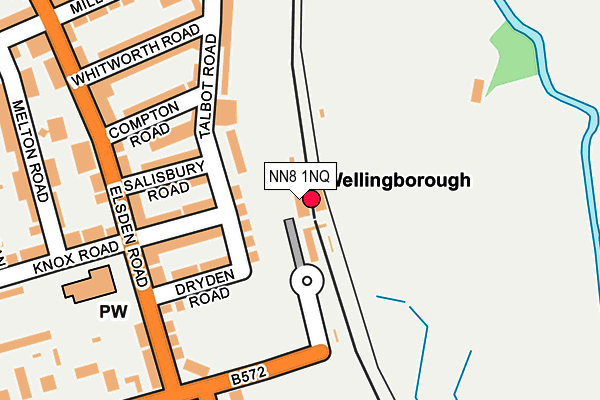
NN8 1NQ is located in the Finedon electoral ward, within the unitary authority of North Northamptonshire and the English Parliamentary constituency of Wellingborough. The Sub Integrated Care Board (ICB) Location is NHS Northamptonshire ICB - 78H and the police force is Northamptonshire. This postcode has been in use since January 1980.


GetTheData
Source: OS OpenMap – Local (Ordnance Survey)
Source: OS VectorMap District (Ordnance Survey)
Licence: Open Government Licence (requires attribution)
| Easting | 490335 |
| Northing | 268123 |
| Latitude | 52.303821 |
| Longitude | -0.676560 |
GetTheData
Source: Open Postcode Geo
Licence: Open Government Licence
| Country | England |
| Postcode District | NN8 |
➜ See where NN8 is on a map ➜ Where is Wellingborough? | |
GetTheData
Source: Land Registry Price Paid Data
Licence: Open Government Licence
Elevation or altitude of NN8 1NQ as distance above sea level:
| Metres | Feet | |
|---|---|---|
| Elevation | 50m | 164ft |
Elevation is measured from the approximate centre of the postcode, to the nearest point on an OS contour line from OS Terrain 50, which has contour spacing of ten vertical metres.
➜ How high above sea level am I? Find the elevation of your current position using your device's GPS.
GetTheData
Source: Open Postcode Elevation
Licence: Open Government Licence
| Ward | Finedon |
| Constituency | Wellingborough |
GetTheData
Source: ONS Postcode Database
Licence: Open Government Licence
| Rail Station Forecourt (Midland Road) | Wellingborough | 21m |
| Dryden Road (Elsden Road) | Wellingborough | 187m |
| Dryden Road (Elsden Road) | Wellingborough | 196m |
| Colwell Road (Senwick Road) | Wellingborough | 249m |
| Colwell Road (Senwick Road) | Wellingborough | 252m |
| Wellingborough Station | 0km |
GetTheData
Source: NaPTAN
Licence: Open Government Licence
GetTheData
Source: ONS Postcode Database
Licence: Open Government Licence


➜ Get more ratings from the Food Standards Agency
GetTheData
Source: Food Standards Agency
Licence: FSA terms & conditions
| Last Collection | |||
|---|---|---|---|
| Location | Mon-Fri | Sat | Distance |
| Royal Mail Wellingborough | 18:30 | 11:00 | 158m |
| Senwick Road | 16:00 | 11:00 | 631m |
| Eastfield Road | 17:00 | 11:00 | 670m |
GetTheData
Source: Dracos
Licence: Creative Commons Attribution-ShareAlike
The below table lists the International Territorial Level (ITL) codes (formerly Nomenclature of Territorial Units for Statistics (NUTS) codes) and Local Administrative Units (LAU) codes for NN8 1NQ:
| ITL 1 Code | Name |
|---|---|
| TLF | East Midlands (England) |
| ITL 2 Code | Name |
| TLF2 | Leicestershire, Rutland and Northamptonshire |
| ITL 3 Code | Name |
| TLF25 | North Northamptonshire |
| LAU 1 Code | Name |
| E07000156 | Wellingborough |
GetTheData
Source: ONS Postcode Directory
Licence: Open Government Licence
The below table lists the Census Output Area (OA), Lower Layer Super Output Area (LSOA), and Middle Layer Super Output Area (MSOA) for NN8 1NQ:
| Code | Name | |
|---|---|---|
| OA | E00138961 | |
| LSOA | E01027315 | Wellingborough 004C |
| MSOA | E02005695 | Wellingborough 004 |
GetTheData
Source: ONS Postcode Directory
Licence: Open Government Licence
| NN8 1EQ | Talbot Road | 69m |
| NN8 1QA | Talbot Road | 87m |
| NN8 1QB | Knox Road | 116m |
| NN8 1PZ | Dryden Road | 125m |
| NN8 1QF | Salisbury Road | 136m |
| NN8 1QG | Compton Road | 156m |
| NN8 1PY | Elsden Road | 179m |
| NN8 1QH | Talbot Road | 185m |
| NN8 1QD | Elsden Road | 208m |
| NN8 1PX | Knox Road | 218m |
GetTheData
Source: Open Postcode Geo; Land Registry Price Paid Data
Licence: Open Government Licence