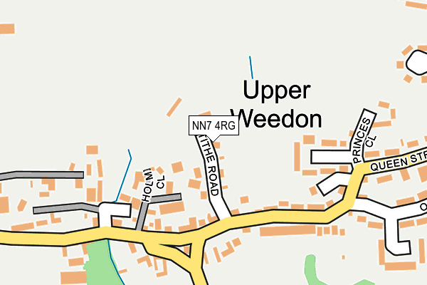
NN7 4RG lies on Tithe Road in Weedon, Northampton. NN7 4RG is located in the Woodford and Weedon electoral ward, within the unitary authority of West Northamptonshire and the English Parliamentary constituency of Daventry. The Sub Integrated Care Board (ICB) Location is NHS Northamptonshire ICB - 78H and the police force is Northamptonshire. This postcode has been in use since January 1980.


GetTheData
Source: OS OpenMap – Local (Ordnance Survey)
Source: OS VectorMap District (Ordnance Survey)
Licence: Open Government Licence (requires attribution)
| Easting | 462119 |
| Northing | 259035 |
| Latitude | 52.226024 |
| Longitude | -1.091991 |
GetTheData
Source: Open Postcode Geo
Licence: Open Government Licence
| Street | Tithe Road |
| Locality | Weedon |
| Town/City | Northampton |
| Country | England |
| Postcode District | NN7 |
➜ See where NN7 is on a map ➜ Where is Weedon Bec? | |
GetTheData
Source: Land Registry Price Paid Data
Licence: Open Government Licence
Elevation or altitude of NN7 4RG as distance above sea level:
| Metres | Feet | |
|---|---|---|
| Elevation | 100m | 328ft |
Elevation is measured from the approximate centre of the postcode, to the nearest point on an OS contour line from OS Terrain 50, which has contour spacing of ten vertical metres.
➜ How high above sea level am I? Find the elevation of your current position using your device's GPS.
GetTheData
Source: Open Postcode Elevation
Licence: Open Government Licence
| Ward | Woodford And Weedon |
| Constituency | Daventry |
GetTheData
Source: ONS Postcode Database
Licence: Open Government Licence
| Holm Close (Queen Street) | Upper Weedon | 152m |
| Holm Close (Queen Street) | Upper Weedon | 158m |
| Oak Street (New Croft) | Lower Weedon | 424m |
| Oak Street (New Croft) | Lower Weedon | 452m |
| Community Centre (West Street) | Lower Weedon | 553m |
GetTheData
Source: NaPTAN
Licence: Open Government Licence
| Percentage of properties with Next Generation Access | 100.0% |
| Percentage of properties with Superfast Broadband | 100.0% |
| Percentage of properties with Ultrafast Broadband | 0.0% |
| Percentage of properties with Full Fibre Broadband | 0.0% |
Superfast Broadband is between 30Mbps and 300Mbps
Ultrafast Broadband is > 300Mbps
| Median download speed | 16.7Mbps |
| Average download speed | 16.2Mbps |
| Maximum download speed | 25.98Mbps |
| Median upload speed | 4.8Mbps |
| Average upload speed | 4.1Mbps |
| Maximum upload speed | 6.64Mbps |
| Percentage of properties unable to receive 2Mbps | 0.0% |
| Percentage of properties unable to receive 5Mbps | 0.0% |
| Percentage of properties unable to receive 10Mbps | 0.0% |
| Percentage of properties unable to receive 30Mbps | 0.0% |
GetTheData
Source: Ofcom
Licence: Ofcom Terms of Use (requires attribution)
GetTheData
Source: ONS Postcode Database
Licence: Open Government Licence

➜ Get more ratings from the Food Standards Agency
GetTheData
Source: Food Standards Agency
Licence: FSA terms & conditions
| Last Collection | |||
|---|---|---|---|
| Location | Mon-Fri | Sat | Distance |
| Weedon | 16:30 | 10:00 | 654m |
| Hillside | 16:30 | 10:30 | 1,000m |
| Weedon Tso | 16:45 | 10:15 | 1,015m |
GetTheData
Source: Dracos
Licence: Creative Commons Attribution-ShareAlike
The below table lists the International Territorial Level (ITL) codes (formerly Nomenclature of Territorial Units for Statistics (NUTS) codes) and Local Administrative Units (LAU) codes for NN7 4RG:
| ITL 1 Code | Name |
|---|---|
| TLF | East Midlands (England) |
| ITL 2 Code | Name |
| TLF2 | Leicestershire, Rutland and Northamptonshire |
| ITL 3 Code | Name |
| TLF24 | West Northamptonshire |
| LAU 1 Code | Name |
| E07000151 | Daventry |
GetTheData
Source: ONS Postcode Directory
Licence: Open Government Licence
The below table lists the Census Output Area (OA), Lower Layer Super Output Area (LSOA), and Middle Layer Super Output Area (MSOA) for NN7 4RG:
| Code | Name | |
|---|---|---|
| OA | E00137447 | |
| LSOA | E01027024 | Daventry 009C |
| MSOA | E02005627 | Daventry 009 |
GetTheData
Source: ONS Postcode Directory
Licence: Open Government Licence
| NN7 4TJ | Holm Close | 92m |
| NN7 4RA | Queen Street | 113m |
| NN7 4RF | Dukelands | 136m |
| NN7 4PR | Home Farm Close | 163m |
| NN7 4RE | Princes Close | 231m |
| NN7 4RH | Oaklands | 318m |
| NN7 4QZ | Queens Park | 320m |
| NN7 4RQ | Oak Street | 321m |
| NN7 4QY | Kings Park | 352m |
| NN7 4QF | Priory Court | 368m |
GetTheData
Source: Open Postcode Geo; Land Registry Price Paid Data
Licence: Open Government Licence