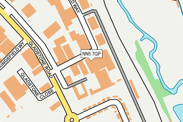
NN5 7QP is located in the Dallington Spencer electoral ward, within the unitary authority of West Northamptonshire and the English Parliamentary constituency of Northampton South. The Sub Integrated Care Board (ICB) Location is NHS Northamptonshire ICB - 78H and the police force is Northamptonshire. This postcode has been in use since January 1980.


GetTheData
Source: OS OpenMap – Local (Ordnance Survey)
Source: OS VectorMap District (Ordnance Survey)
Licence: Open Government Licence (requires attribution)
| Easting | 474388 |
| Northing | 262143 |
| Latitude | 52.252443 |
| Longitude | -0.911721 |
GetTheData
Source: Open Postcode Geo
Licence: Open Government Licence
| Country | England |
| Postcode District | NN5 |
➜ See where NN5 is on a map ➜ Where is Northampton? | |
GetTheData
Source: Land Registry Price Paid Data
Licence: Open Government Licence
Elevation or altitude of NN5 7QP as distance above sea level:
| Metres | Feet | |
|---|---|---|
| Elevation | 70m | 230ft |
Elevation is measured from the approximate centre of the postcode, to the nearest point on an OS contour line from OS Terrain 50, which has contour spacing of ten vertical metres.
➜ How high above sea level am I? Find the elevation of your current position using your device's GPS.
GetTheData
Source: Open Postcode Elevation
Licence: Open Government Licence
| Ward | Dallington Spencer |
| Constituency | Northampton South |
GetTheData
Source: ONS Postcode Database
Licence: Open Government Licence
| Pembroke Road (Gladstone Road) | Spencer | 163m |
| Portakabin Factory (Gladstone Road) | King's Heath | 260m |
| Glebeland Road (Merthyr Road) | Spencer | 327m |
| Portakabin Factory (Gladstone Road) | King's Heath | 373m |
| St Francis Avenue (Gladstone Road) | Spencer | 382m |
| Northampton Station | 1.7km |
GetTheData
Source: NaPTAN
Licence: Open Government Licence
| Median download speed | 79.4Mbps |
| Average download speed | 51.9Mbps |
| Maximum download speed | 80.00Mbps |
| Median upload speed | 20.0Mbps |
| Average upload speed | 12.8Mbps |
| Maximum upload speed | 20.00Mbps |
GetTheData
Source: Ofcom
Licence: Ofcom Terms of Use (requires attribution)
Estimated total energy consumption in NN5 7QP by fuel type, 2015.
| Consumption (kWh) | 354,398 |
|---|---|
| Meter count | 12 |
| Mean (kWh/meter) | 29,533 |
| Median (kWh/meter) | 30,182 |
GetTheData
Source: Postcode level gas estimates: 2015 (experimental)
Source: Postcode level electricity estimates: 2015 (experimental)
Licence: Open Government Licence
GetTheData
Source: ONS Postcode Database
Licence: Open Government Licence


➜ Get more ratings from the Food Standards Agency
GetTheData
Source: Food Standards Agency
Licence: FSA terms & conditions
| Last Collection | |||
|---|---|---|---|
| Location | Mon-Fri | Sat | Distance |
| Heathfield Way | 18:30 | 36m | |
| Dallington Tso | 17:30 | 12:00 | 628m |
| Kings Heath Post Office | 17:30 | 11:30 | 656m |
GetTheData
Source: Dracos
Licence: Creative Commons Attribution-ShareAlike
The below table lists the International Territorial Level (ITL) codes (formerly Nomenclature of Territorial Units for Statistics (NUTS) codes) and Local Administrative Units (LAU) codes for NN5 7QP:
| ITL 1 Code | Name |
|---|---|
| TLF | East Midlands (England) |
| ITL 2 Code | Name |
| TLF2 | Leicestershire, Rutland and Northamptonshire |
| ITL 3 Code | Name |
| TLF24 | West Northamptonshire |
| LAU 1 Code | Name |
| E07000154 | Northampton |
GetTheData
Source: ONS Postcode Directory
Licence: Open Government Licence
The below table lists the Census Output Area (OA), Lower Layer Super Output Area (LSOA), and Middle Layer Super Output Area (MSOA) for NN5 7QP:
| Code | Name | |
|---|---|---|
| OA | E00138587 | |
| LSOA | E01027242 | Northampton 017C |
| MSOA | E02005666 | Northampton 017 |
GetTheData
Source: ONS Postcode Directory
Licence: Open Government Licence
| NN5 7ER | Pembroke Road | 223m |
| NN5 7ES | Pembroke Gardens | 265m |
| NN5 7EP | St Francis Avenue | 374m |
| NN5 7DD | Penarth Road | 388m |
| NN5 7DE | Streatfield Road | 398m |
| NN5 7HB | Glebeland Crescent | 400m |
| NN5 7QS | Kingsfield Close | 403m |
| NN5 7EL | Gladstone Road | 423m |
| NN5 7BT | Merthyr Road | 425m |
| NN5 7QN | Kingsfield Way | 430m |
GetTheData
Source: Open Postcode Geo; Land Registry Price Paid Data
Licence: Open Government Licence