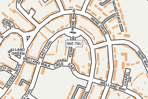
NN5 7NU lies on Kennet Green in Northampton. NN5 7NU is located in the Dallington Spencer electoral ward, within the unitary authority of West Northamptonshire and the English Parliamentary constituency of Northampton South. The Sub Integrated Care Board (ICB) Location is NHS Northamptonshire ICB - 78H and the police force is Northamptonshire. This postcode has been in use since January 1980.


GetTheData
Source: OS OpenMap – Local (Ordnance Survey)
Source: OS VectorMap District (Ordnance Survey)
Licence: Open Government Licence (requires attribution)
| Easting | 473860 |
| Northing | 262784 |
| Latitude | 52.258276 |
| Longitude | -0.919314 |
GetTheData
Source: Open Postcode Geo
Licence: Open Government Licence
| Street | Kennet Green |
| Town/City | Northampton |
| Country | England |
| Postcode District | NN5 |
➜ See where NN5 is on a map ➜ Where is Northampton? | |
GetTheData
Source: Land Registry Price Paid Data
Licence: Open Government Licence
Elevation or altitude of NN5 7NU as distance above sea level:
| Metres | Feet | |
|---|---|---|
| Elevation | 90m | 295ft |
Elevation is measured from the approximate centre of the postcode, to the nearest point on an OS contour line from OS Terrain 50, which has contour spacing of ten vertical metres.
➜ How high above sea level am I? Find the elevation of your current position using your device's GPS.
GetTheData
Source: Open Postcode Elevation
Licence: Open Government Licence
| Ward | Dallington Spencer |
| Constituency | Northampton South |
GetTheData
Source: ONS Postcode Database
Licence: Open Government Licence
| Nene Walk (East Oval) | King's Heath | 81m |
| Welland Walk (East Oval) | King's Heath | 129m |
| 46 South Oval (South Oval) | King's Heath | 175m |
| Park Drive | King's Heath | 310m |
| South Oval Shops (South Oval) | King's Heath | 346m |
| Northampton Station | 2.5km |
GetTheData
Source: NaPTAN
Licence: Open Government Licence
| Percentage of properties with Next Generation Access | 100.0% |
| Percentage of properties with Superfast Broadband | 100.0% |
| Percentage of properties with Ultrafast Broadband | 0.0% |
| Percentage of properties with Full Fibre Broadband | 0.0% |
Superfast Broadband is between 30Mbps and 300Mbps
Ultrafast Broadband is > 300Mbps
| Median download speed | 49.7Mbps |
| Average download speed | 58.5Mbps |
| Maximum download speed | 200.00Mbps |
| Median upload speed | 2.1Mbps |
| Average upload speed | 6.9Mbps |
| Maximum upload speed | 19.53Mbps |
| Percentage of properties unable to receive 2Mbps | 0.0% |
| Percentage of properties unable to receive 5Mbps | 0.0% |
| Percentage of properties unable to receive 10Mbps | 0.0% |
| Percentage of properties unable to receive 30Mbps | 0.0% |
GetTheData
Source: Ofcom
Licence: Ofcom Terms of Use (requires attribution)
Estimated total energy consumption in NN5 7NU by fuel type, 2015.
| Consumption (kWh) | 163,257 |
|---|---|
| Meter count | 15 |
| Mean (kWh/meter) | 10,884 |
| Median (kWh/meter) | 10,900 |
| Consumption (kWh) | 59,457 |
|---|---|
| Meter count | 16 |
| Mean (kWh/meter) | 3,716 |
| Median (kWh/meter) | 2,931 |
GetTheData
Source: Postcode level gas estimates: 2015 (experimental)
Source: Postcode level electricity estimates: 2015 (experimental)
Licence: Open Government Licence
GetTheData
Source: ONS Postcode Database
Licence: Open Government Licence


➜ Get more ratings from the Food Standards Agency
GetTheData
Source: Food Standards Agency
Licence: FSA terms & conditions
| Last Collection | |||
|---|---|---|---|
| Location | Mon-Fri | Sat | Distance |
| Nene Drive | 17:30 | 11:30 | 179m |
| Kings Heath Post Office | 17:30 | 11:30 | 283m |
| Avon Drive | 17:30 | 11:30 | 364m |
GetTheData
Source: Dracos
Licence: Creative Commons Attribution-ShareAlike
The below table lists the International Territorial Level (ITL) codes (formerly Nomenclature of Territorial Units for Statistics (NUTS) codes) and Local Administrative Units (LAU) codes for NN5 7NU:
| ITL 1 Code | Name |
|---|---|
| TLF | East Midlands (England) |
| ITL 2 Code | Name |
| TLF2 | Leicestershire, Rutland and Northamptonshire |
| ITL 3 Code | Name |
| TLF24 | West Northamptonshire |
| LAU 1 Code | Name |
| E07000154 | Northampton |
GetTheData
Source: ONS Postcode Directory
Licence: Open Government Licence
The below table lists the Census Output Area (OA), Lower Layer Super Output Area (LSOA), and Middle Layer Super Output Area (MSOA) for NN5 7NU:
| Code | Name | |
|---|---|---|
| OA | E00138575 | |
| LSOA | E01027243 | Northampton 017D |
| MSOA | E02005666 | Northampton 017 |
GetTheData
Source: ONS Postcode Directory
Licence: Open Government Licence
| NN5 7NT | Park Crescent East | 47m |
| NN5 7NR | East Oval | 62m |
| NN5 7NP | East Oval | 71m |
| NN5 7NS | Welland Way | 99m |
| NN5 7NH | Nene Walk | 126m |
| NN5 7NJ | Wharf Green | 144m |
| NN5 7NX | Welland Walk | 160m |
| NN5 7ND | Welland Way | 161m |
| NN5 7NG | Nene Way | 168m |
| NN5 7LW | Severn Drive | 174m |
GetTheData
Source: Open Postcode Geo; Land Registry Price Paid Data
Licence: Open Government Licence